As large wildfires that prompt evacuations, damage homes, and impact local economies become more common, it’s hard not to feel a sense of relief when a wildfire ignites in a remote landscape far from the nearest community.
Yet not everyone can breathe easy when a fire is reported in an unpopulated area. Utility companies with transmission lines running through out-of-the-way places and renewable energy providers with wind turbines and large solar arrays in remote areas are just two examples of businesses whose assets may be at risk from natural hazards when people and communities are not.
"Having [wildfire] hotspot data available to any company in North America or anywhere in the world is hugely important,"' said Mark Carniello, product manager for Indji Systems. "Without it, we and our customers would have much less awareness of where fires are right now and how they might impact their work."
The first word in the company's name, “Indji,” is an Australian Aboriginal term for "close to" and it's a good choice for the company, which offers a real-time hazard monitoring and alert service known as Indji Watch to utility and renewable energy companies in Australia, the United States, Europe, and other countries around the world.
"If you have staff up on a wind turbine 100 meters above the ground in the open countryside of west Texas, you don't want to be out there when there's lightning," Carniello said. "Or, if you're working in a canyon for a utility in California and there's a wildfire 10 miles away, it might take you a while to get out of that area."
Indji Watch's customers also rely on the company's product to ensure their infrastructure are in good condition.
"If a wildfire is approaching a major transmission line, that line could short out and essentially stop operating, so our customers care about the hazards that threaten their operations," said Carniello. "Lightning can actually punch a hole in a wind turbine and if the damage is not addressed quickly, it can cause additional problems. So, our clients need to know where lightning has occurred or where a fire has gone through, because they need to inspect their equipment for damage."
As product manager, Carniello's job is to ensure that Indji Systems products provide customers with the most current information. Because wildfire is among the threats it looks out for, Carniello and his colleagues incorporate active fire data from NASA's Fire Information for Resource Management System (FIRMS) into their hazard alert and monitoring products.

"Fire can a be a tough natural hazard to detect and getting the best information is a continuous challenge. There are many sources of wildfire information, such as the traditional state or federal fire agencies, but they rely on someone calling 911 and reporting a fire. They're not always reliable, especially if the fire is in a remote area," he said. "Now, with these satellites flying overhead and telling you that there's something hot here, which is most likely a fire, we have a fantastic source of information for people with assets in remote areas."
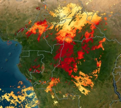
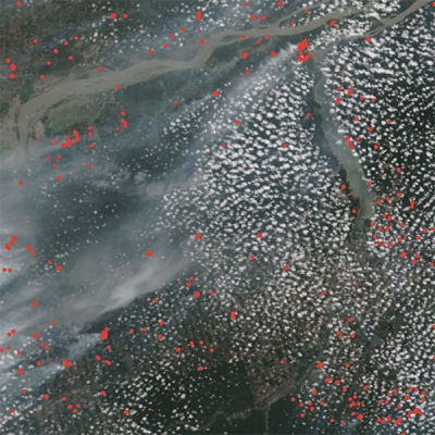
FIRMS provides access to satellite imagery, active fire and hotspot data, and related products that allow users to identify the location, extent, and intensity of wildfire activity. Its near real-time (NRT) data are available within three hours of a satellite overpass and its ultra real-time (URT) data (for the United States only) are available within 60 seconds using direct broadcast. Together, these products make FIRMS a valuable commodity for first responders and resource managers keen to pinpoint the location of a potential wildfire or track the development of established fires, especially in remote or rugged areas.
"Our clients generally care about where the fires are now, so we grab the hotspot data from FIRMS as soon as they become available," Carniello said. "If there’s a fire a long way from a client's infrastructure, the company may not care. Usually, they only want to be alerted for wildfires within a certain distance, like within five miles. When a fire is detected or reported by a fire agency within that distance, they'll receive a notification."
FIRMS' active fire data come from NASA's Moderate Resolution Imaging Spectroradiometer (MODIS) and Visible Infrared Imaging Radiometer Suite (VIIRS) instruments, both of which can detect radiated energy from their respective orbits approximately 440 and 515 miles (705 and 830 kilometers) above Earth's surface.
MODIS flies aboard NASA's Terra and Aqua satellites, and its Fire and Thermal Anomalies product is the foundation of FIRMS active fire products. When MODIS detects a thermal anomaly, which could indicate a wildfire or any significant source of heat, a computer algorithm identifies the center of the one square-kilometer area in which the anomaly is detected. This location is plotted and available to fire crews and wildland managers within three hours of the observation, providing an approximate location of a potential wildfire or hotspot.
VIIRS flies aboard the joint NASA-NOAA Suomi National Polar-orbiting Partnership (Suomi NPP) and the Joint Polar Satellite Systems’ NOAA-20 and -21 satellites. The VIIRS I-band (375 meter) Active Fire product is based on the MODIS Fire and Thermal Anomalies product, which means that the two products complement each other in regard to hotspot detection (i.e., both products have shown good agreement in hotspot detection tests). However, VIIRS provides better response for smaller fires and provides improved mapping of large fire perimeters. Further, the VIIRS 375 m product shows a better response in nighttime observations, when fire activity normally subsides.
In addition to the NRT MODIS and VIIRS data, FIRMS also offers:
- An NRT Landsat Fire and Thermal Anomaly active fire product generated with data from the Operational Land Imager (OLI) instrument aboard Landsat 8 and the Operational Land Imager-2 (OLI-2) aboard Landsat 9. These data are available in approximately 30 minutes from satellite overpass and offer much higher 30-meter resolution compared to the products from MODIS and VIIRS. (Note: This product covers only the continental United States and most of Canada and Mexico at this time.)
- URT active fire data from MODIS and VIIRS for the continental United States within 60 seconds of observation via direct broadcast.
- A short-wave infrared false color composite imagery layer from the Harmonized Landsat and Sentinel-2 (HLS) project. This layer is created with data from the Landsat OLI and OLI-2 instruments and the Multi-Spectral Instrument (MSI) aboard the ESA (European Space Agency) Sentinel-2A and -2B satellites. This product aids active fire detection by providing imagery of active fire fronts at the relatively high spatial resolution of 30 meters along with improved delineation of burned areas.
- Geostationary active fire data from the Advanced Baseline Imager (ABI) aboard NOAA's GOES-16 and -18 satellites, the Spinning Enhanced Visible and Infra-Red Imager (SEVIRI) aboard the ESA Meteosat-9 and -11 satellites, and the Advanced Himawari Imager (AHI) aboard the JAXA (Japan Aerospace Exploration Agency) Himawari-8 satellite. These sensors provide data at 10- to 15-minute intervals, so they can detect more fire events and capture their growth and change. However, the spatial resolution of geostationary satellite data is coarser than MODIS data and therefore less sensitive to small fires.

Taken together, this suite of NRT and URT data make FIRMS a valuable tool for detecting ignitions, tracking the spread of ongoing fires, and assessing their impact.
In Australia, the need utility companies had for reliable fire location information came to the fore during Black Saturday in 2009, when bushfires in the Australian state of Victoria caused the deaths of 173 people and burned more than 450,000 hectares (more than 1.1 million acres).
"In the early 2000s, we had a catastrophic outbreak of wildfires here in Australia and during that event the fire agencies lost comms to a lot of their crews on the ground; they had no idea where the fires were," said Carniello. "Then they thought, 'Oh, let's look at the satellite data and let's see what it's showing us.' That was a key learning moment for us."
But it wasn't the only one. As Indji Watch developed its alert systems and began incorporating active fire data from FIRMS and other sources, its staff had to become familiar with every aspect of using wildfire data from satellites.
"In the early days, we had to educate ourselves on these satellites, on how to get the data from the different receiving stations after each overpass, how the data were processed, and how to use the files," Carniello said. "Over time, NASA has become better and better at providing these data in easier to consume formats. So, now we just grab the raw data, but the nice thing about FIRMS is that the raw data [are] harmonized in a way that makes it easier for us to use and there are less variables we have to consider when building our own systems."

For Diane Davies, operations manager for NASA's Land, Atmosphere Near real-time Capability for EO (LANCE), Indji System's reliance on FIRMS data is indicative of the value that FIRMS provides to users around the world.
"We see spikes in visitors viewing the FIRMS map interface when there are large fire events, but we are seeing increasing numbers of users routinely pull the active fire data via FIRMS web services," Davies said. "Indji is a great example of this type of user—they routinely pull data from FIRMS into a customized GIS [geographic information system] and add value to it by combining it with other geospatial data."
FIRMS is part of NASA's LANCE, which provides more than 100 NRT products from instruments aboard Earth observation satellites. LANCE, in turn, is part of NASA's Earth Observing System Data and Information System (EOSDIS), which is responsible for NASA's Earth science data collection. FIRMS was developed by the University of Maryland in 2007 with funds from NASA and the United Nations Food and Agriculture Organization (UNFAO). NASA began offering FIRMS NRT data in 2007, and the UNFAO began offering the data in 2010 through its Global Fire Information Management System (GFIMS).
Resources
Active fire data for the last 24 hours, 48 hours, or week can be downloaded in shapefile, KML, WMS, or text file formats; data older than seven days can be obtained using the FIRMS Archive Download Tool.