We are in the process of migrating all NASA Earth science data sites into Earthdata from now until end of 2026. Not all NASA Earth science data and resources will appear here until then. Thank you for your patience as we make this transition.
Read about the Web Unification Project
Terra Resources
Terra Learning Resources

The Emergency Environmental Health Dashboard helped local communities assess water quality risks and infrastructure damage following Hurricane Helene and Tropical Storm Chantal.
Data in Action
Nov. 18, 2025

This ARSET training introduces participants to several capabilities within FIRMS that were not included in the previous ARSET training.
Training
Jan. 14-21, 2026

Join us on Wed., September 17, 2025, at 2:00 p.m. EDT (-04:00 UTC) to learn how to discover, access, and use NASA's near real-time global flood products .
Webinar
Aug. 29, 2025

The MODIS Near Real-Time (NRT) Global Flood Product helps communities assess the aftermath of flooding in Australia.
Data in Action
July 17, 2025

Join NASA’s LAADS DAAC to learn how new tools available through Harmony services help users work with Level-1 and atmospheric datasets more efficiently.
Webinar
July 16, 2025

The eBird project uses NASA data and observations from amateur birdwatchers to provide insights into the decline in avian populations throughout North America.
Data in Action
June 17, 2025

Agricultural burning in Kansas produces smoky skies and healthy crops.
Data in Action
June 6, 2025

Artificial intelligence methods can be powerful tools to study our oceans.
Data in Action
Dec. 12, 2024
SHOWING 8 OF 235
Terra News
View All News
Filters

Imagery of Earth at night provide unique opportunities for research. Dr. Miller uses these data in his studies of Earth’s nocturnal environment.
Data User Story
April 13, 2021

The provisional public release of the Harmonized Landsat Sentinel-2 (HLS) dataset through NASA’s LP DAAC opens new avenues for global terrestrial research.
Feature Article
April 12, 2021

Image captured on 1 March 2021, by the MODIS instrument, aboard the Terra satellite.
Worldview Image of the Week
March 8, 2021
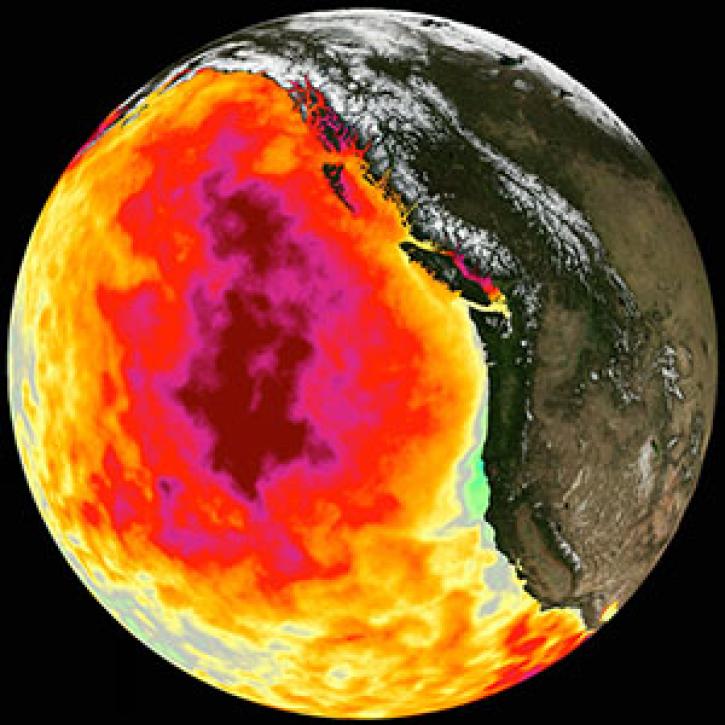
Too much warmth and too little wind fueled a massive marine heat wave along the Pacific Coast.
Feature Article
March 1, 2021

NASA near real-time Earth observing data are vital to emergency response. Dave Jones enables these data to be used collaboratively in real time across platforms by emergency responders and managers.
Data User Story
March 1, 2021

New VIIRS imagery from NOAA-20 along with new ways to evaluate and select imagery layers make NASA Worldview more useful than ever.
Feature Article
March 1, 2021

SRTMGL1 coverage now includes Africa, Europe, North America, South America, Asia, and Australia in 1° X 1° tiles at 1 arc second (about 30 meters) resolution.
News
March 1, 2021

See who took home top honors in the world’s largest global hackathon.
News
March 1, 2021
SHOWING 8 OF 450
Frequently Asked Questions
Earthdata Forum
Our online forum provides a space for users to browse thousands of FAQs about research needs, data, and data applications. You can also submit new questions for our experts to answer.
Submit Questions to Earthdata Forumand View Expert Responses