We are in the process of migrating all NASA Earth science data sites into Earthdata from now until end of 2026. Not all NASA Earth science data and resources will appear here until then. Thank you for your patience as we make this transition.
Read about the Web Unification Project
Terra Resources
Terra Learning Resources

View a demonstration of the Point Sampler using the Application for Extracting and Exploring Analysis Ready Samples (AppEEARS).
Tutorial
Dec. 21, 2018

Read stories from the 2017 issue of Sensing our Planet to learn about the many uses of MODIS data distributed by LP DAAC.
Data in Action
Dec. 19, 2018
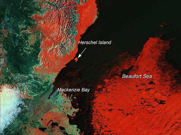
Learn how scientists use remote sensing data to study sea ice patterns to see how changes can influence weather, climate, and animal populations in these regions.
Data in Action
Dec. 6, 2018

Read stories from the 2016 issue of Sensing our Planet to learn about the many uses of MODIS data distributed by LP DAAC.
Data in Action
Nov. 28, 2018

NASA scientists examined the sea surface temperature response associated with this 2018 hurricane.
Data in Action
Nov. 26, 2018

The Application for Extracting and Exploring Analysis Ready Samples (AppEEARS) tool simplifies data access, extraction, transformation, and visualization for defined areas.
Tutorial
Nov. 9, 2018

Learn how remote sensing is used to determine the unique spectral characteristics of plants.
Tutorial
Oct. 29, 2018

Learn how satellite data supported research on forest growing seasons in Thailand, land degradation risk in Cyprus, and agricultural yield forecasting in Eastern Europe.
Data in Action
Oct. 25, 2018
SHOWING 8 OF 235
Terra News
View All News
Filters

Access Moderate Resolution Imaging Spectroradiometer (MODIS) version 6.1 land data products starting in summer 2020.
News
May 7, 2020

Image captured on 20 July 2015, by the MODIS instrument aboard the Terra satellite.
Worldview Image of the Week
Feb. 28, 2020

Image displaying sea surface temperature of the Pacific and Atlantic Oceans for 31 January 2016.
Worldview Image of the Week
Feb. 28, 2020
New features include a preview image and layer description when a layer search is conducted.
Blog
Feb. 27, 2020

Image captured on 3 December 2016 by the MODIS instrument, aboard the Terra satellite.
Worldview Image of the Week
Feb. 26, 2020

Image captured on 16 January 2018, by the MODIS instrument, aboard the Terra satellite.
Worldview Image of the Week
Feb. 26, 2020

Image captured on 29 July 2018, by the MODIS instrument, aboard the Terra satellite.
Worldview Image of the Week
Feb. 26, 2020

Image captured on 7 December 2018, by the MODIS instrument, aboard the Terra satellite.
Worldview Image of the Week
Feb. 26, 2020
SHOWING 8 OF 450
Frequently Asked Questions
Earthdata Forum
Our online forum provides a space for users to browse thousands of FAQs about research needs, data, and data applications. You can also submit new questions for our experts to answer.
Submit Questions to Earthdata Forumand View Expert Responses