We are in the process of migrating all NASA Earth science data sites into Earthdata from now until end of 2026. Not all NASA Earth science data and resources will appear here until then. Thank you for your patience as we make this transition.
Read about the Web Unification Project
Terra Resources
Terra Learning Resources

Read how researchers from NASA's DEVELOP team analyzed temperature trends in the Northeast to create maps for the agricultural and energy industries.
Data in Action
April 13, 2018

Learn how a NASA DEVELOP project used MODIS and ASTER data to create a model of social vulnerability to fire hazards in the Appalachian forests.
Data in Action
March 7, 2018

See ASTER instrument images revealing the transformation of South Korea's Mount Gariwang for the 2018 Winter Olympics.
Data in Action
Feb. 21, 2018

This ARSET training introduces the Variable Infiltration Capacity Model, sources of satellite-derived input data, and implementation of the model.
Training
Feb. 15 - March 1, 2018

The ability to understand where fish are likely to be and when they are likely to be there is critical for the sustainable management of fisheries.
Data in Action
Feb. 1, 2018

This ARSET training teaches how to use Python scripts to map and analyze air quality data through hands-on exercises.
Training
Jan. 17-22, 2018

In Spring 2017, DEVELOP researchers in Phoenix used NASA data to determine how hot area bus stops are in summer to determine which ones need shelters.
Data in Action
Dec. 27, 2017

Learn how surface reflectance and albedo as measured by satellite data help scientists understand the topography and vegetation cover of Earth surfaces.
Data in Action
Nov. 30, 2017
SHOWING 8 OF 235
Terra News
View All News
Filters

Images captured on Oct 11 and 12, 2021, by the MODIS instrument aboard the Aqua and Terra satellites.
Worldview Image of the Week
Dec. 21, 2021
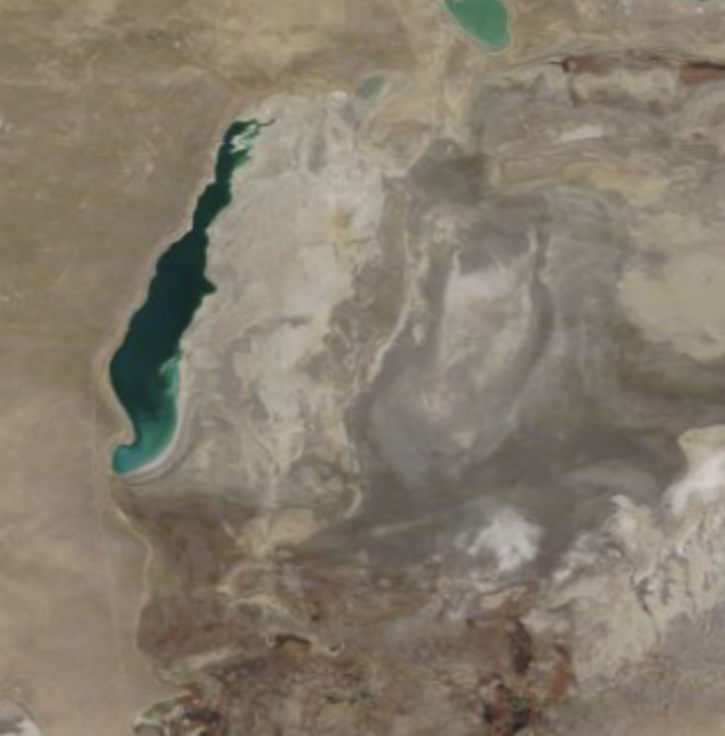
Worldview Image of the Week: Comparison image of Aral Sea
Worldview Image of the Week
Dec. 7, 2021
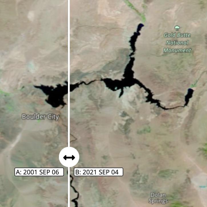
Images captured on Sep 6 and Sep 4, 2021, by the MODIS instrument aboard the Terra satellite.
Worldview Image of the Week
Nov. 1, 2021

Image captured on Aug 16, 2021, by the MODIS instrument aboard NASA's Terra satellite.
Worldview Image of the Week
Nov. 1, 2021

Satellites provide crucial information for researchers to monitor and help improve agricultural productivity in India.
Feature Article
Oct. 22, 2021
With its high-resolution HawkEye instrument, SeaHawk has shown CubeSats are an inexpensive and timely way to obtain high-quality ocean color data.
Feature Article
Oct. 20, 2021

Data available from NASA’s LP DAAC helps scientists like Dr. Robert Wright develop systems for autonomously detecting volcanic eruptions from space.
Data User Story
Oct. 20, 2021

POWER is releasing new user-defined analytic capabilities in version 2.
News
Aug. 16, 2021
SHOWING 8 OF 450
Frequently Asked Questions
Earthdata Forum
Our online forum provides a space for users to browse thousands of FAQs about research needs, data, and data applications. You can also submit new questions for our experts to answer.
Submit Questions to Earthdata Forumand View Expert Responses