We are in the process of migrating all NASA Earth science data sites into Earthdata from now until end of 2026. Not all NASA Earth science data and resources will appear here until then. Thank you for your patience as we make this transition.
Read about the Web Unification Project
Terra Resources
Terra Learning Resources

NASA DEVELOP teams used MODIS and ASTER data to address wildfire impacts, flooding risks, and wildlife conservation through remote sensing.
Data in Action
Nov. 18, 2015

Discover how NASA data support amphibian habitat mapping, classification of Amazonian wetland vegetation, and flood regime monitoring in Botswana’s Okavango Delta.
Data in Action
Oct. 28, 2015

Learn how MODIS data were used to update the 1992 Montana Climate Atlas to better understand the state's climate and how it relates to resources and industries.
Data in Action
Oct. 21, 2015

Discover how MODIS data help track changes in snow water equivalents in the Sierra Nevada Mountains to help forecast drought in California.
Data in Action
Sept. 30, 2015

Examining changes and recovery of the Chandeleur Barrier Islands post-Hurricane Katrina using remote sensing data.
Data in Action
Aug. 26, 2015

See how a NASA DEVELOP team used MODIS data to create a drought-monitoring tool to benefit the agriculture and energy sectors.
Data in Action
July 1, 2015

See how MODIS data are used to determine areas susceptible to water-stress to show the relative health of the vegetation compared to the same area with healthy vegetation.
Data in Action
June 25, 2015

Discover how researchers used NASA remote sensing data to analyze the eruption of Calbuco Volcano and its impact on the surrounding environment.
Data in Action
May 29, 2015
SHOWING 8 OF 235
Terra News
View All News
Filters

Imagery of Earth at night provide unique opportunities for research. Dr. Miller uses these data in his studies of Earth’s nocturnal environment.
Data User Story
April 13, 2021

The provisional public release of the Harmonized Landsat Sentinel-2 (HLS) dataset through NASA’s LP DAAC opens new avenues for global terrestrial research.
Feature Article
April 12, 2021

Image captured on 1 March 2021, by the MODIS instrument, aboard the Terra satellite.
Worldview Image of the Week
March 8, 2021
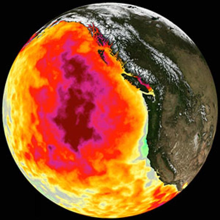
Too much warmth and too little wind fueled a massive marine heat wave along the Pacific Coast.
Feature Article
March 1, 2021

NASA near real-time Earth observing data are vital to emergency response. Dave Jones enables these data to be used collaboratively in real time across platforms by emergency responders and managers.
Data User Story
March 1, 2021

New VIIRS imagery from NOAA-20 along with new ways to evaluate and select imagery layers make NASA Worldview more useful than ever.
Feature Article
March 1, 2021

SRTMGL1 coverage now includes Africa, Europe, North America, South America, Asia, and Australia in 1° X 1° tiles at 1 arc second (about 30 meters) resolution.
News
March 1, 2021

See who took home top honors in the world’s largest global hackathon.
News
March 1, 2021
SHOWING 8 OF 450
Frequently Asked Questions
Earthdata Forum
Our online forum provides a space for users to browse thousands of FAQs about research needs, data, and data applications. You can also submit new questions for our experts to answer.
Submit Questions to Earthdata Forumand View Expert Responses