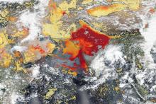
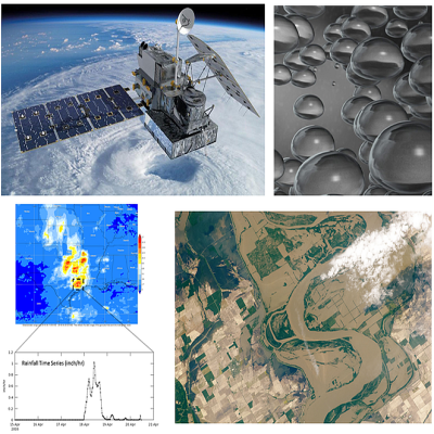
NASA satellites have orbited Earth for decades, gathering data on land use changes, the health of plants, the temperature of the land, and a slew of other data—information that can be put to use by our nation’s farmers and others in the field of agriculture and water management.
As with all NASA data, these resources are available fully, openly, and without restriction, including the more than 90 petabytes (PB) of Earth observation data in NASA's Earth Observing System Data and Information System (EOSDIS) collection. New to using NASA Earth science data? Our Earthdata Get Started page will help give you the foundation you need to search, visualize, and work with NASA Earth observing data and analysis tools.
Data Pathfinders
Data Pathfinders provide direct links to commonly-used datasets across NASA’s Earth science data collections. They are intended to familiarize users with datasets applicable to various areas of study (such as disasters, diseases, or sea level change) and provide guidance on data resolutions (spectral, spatial, and temporal) along with links to data sources. Data Pathfinders relevant to agriculture and water management are:
- Agriculture and Water Management: This Data Pathfinder is directed toward agricultural and water resource managers, decision makers, and anyone interested in using NASA data to monitor crop production or water availability
- Water Quality: This Data Pathfinder is geared to water quality managers and researchers who need to monitor bodies of water locally, regionally, and globally, and helps those who are trying to determine the impacts of changes in water quality to ecosystems, humans, and the environment and to restore and protect coastal and surface waters
Articles and Data User Profiles

Along with all the great data available through Earthdata Search and NASA's Distributed Active Archive Centers (DAACs), feature articles on the Earthdata website provide information about missions, data, and data applications related to agriculture, crops, and water management. Data User Profiles show how individual scientists and researchers are using NASA Earth science data and how these data are being applied in local communities.
Relevant Articles
ORNL DAAC Releases First GEDI Level 4 Dataset Offering Predictions of Aboveground Biomass Density
New dataset provides the first high-resolution 3D aboveground biomass density estimates for tropical and temperate forests around the globe.
Gridded Level 3 Data Product Facilitates the Use of GEDI Mission Data
The data product offerins gridded estimates of canopy height and ground elevation.
Measuring the World's Croplands
The Global Food Security-support Analysis Data (GFSAD) collection provides detailed maps of agricultural croplands around the world at 30-meter spatial resolution.
Satellites and Citizen Scientists Help Track Water Resources in Bangladesh
NASA satellite data and citizen scientists are giving the government of Bangladesh a better understanding of the country's surface water storage.
Lasering in on Cornfields
New research uses 3D lidar profiles of Earth's surface to map where corn is being grown.
Commercial Satellites Shed Light on Small-Scale Agriculture
Commercial, high-resolution imagery available through the Commercial Smallsat Data Acquisition (CSDA) program can be used to map small-scale agriculture.
Satellites Help Improve Crop Yields in India
Satellites provide crucial information for researchers to monitor and help improve agricultural productivity in India.
Webinars
NASA Earthdata Webinars span the Earth science disciplines and are designed to help users learn about NASA Earth observing data, services, and tools and show users how to work with these resources.
- Advancing Science Capabilities with Data Harmonization: NASA's Harmonized Landsat Sentinel-2 Product
- Access NASA GES DISC Meteorological and Hydrological Data for Flood Analyses
- Explore NASA GEDI Aboveground Biomass Datasets, Services, and Tools at NASA's ORNL DAAC
- Learn How to Discover, Access, and Customize Multiple Datasets Using Earthdata Search
- NASA Worldview—Explore the Earth from Past to Present with Global Satellite Observations
- Discover NASA’s Near Real-Time Data using LANCE
Data Recipes and Tutorials
Data recipes are step-by-step instructions for using and working with Earth science data, information, tools, and services. Tutorials show how to use a wide range of data products, data discovery, and data access tools, including programming languages and related software.
- Data Recipes at NASA's Alaska Satellite Facility DAAC (ASF DAAC)
- Data Recipes at NASA's Goddard Earth Sciences Data and Information Services Center (GES DISC)
- Data Recipes at NASA's Global Hydrometeorology Resource Center DAAC (GHRC DAAC)
- Data Recipes at NASA's Land Processes DAAC (LP DAAC)
- Data Recipes at NASA's Oak Ridge National Laboratory DAAC (ORNL DAAC)
- Tutorials at NASA's Level-1 and Atmosphere Archive and Distribution System DAAC (LAADS DAAC)
Additional Resources
Interactive StoryMap: NASA at Your Table: Earth Data Informs Agriculture and Water Resource Management