Air pollution is the greatest environmental threat to public health globally and accounts for almost 7 million premature deaths every year. Exposure to fine particulate matter, designated PM2.5, reduced average global life expectancy by approximately one year.
NASA's Earth Science Data Systems (ESDS) Program provides unrestricted access to data that can be used to assess air quality as well as the tools and applications for analyzing and working with these data. Along with measurements acquired from airborne and satellite missions, NASA collaborates with federal entities and international space organizations to collect and distribute air quality data.
People living in low socioeconomic neighborhoods and communities may be more vulnerable to poor air quality because of factors including proximity to industrial sources of air pollution, higher rates of underlying health problems, poor nutrition, stress, and historical patterns of environmental injustice. Socioeconomic data in NASA's Earth Observing System Data and Information System (EOSDIS) collection are available through NASA's Socioeconomic Data and Applications Center (SEDAC); additional socioeconomic resources are available in the Earthdata Environmental Justice at NASA Backgrounder.
Data Pathfinders
ESDS Data Pathfinders provide direct links to commonly-used datasets across NASA's Earth science collections. The Air Quality Data Pathfinder is an in-depth resource for NASA datasets, tools, applications, and other resources that can aid studies into air quality.
NASA Worldview
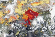
The NASA Worldview imagery mapping and visualization application allows users to select numerous layers that can be used to assess air quality, many of which are available in near real-time (three hours or less after a satellite observation). The Worldview comparison feature enables changes in the environment to be tracked over time, such as changes in aerosol concentrations following a volcanic eruption or wildfire.
In the Worldview comparison image below, high concentrations of dust in the Gobi Desert in Central Asia appear as a grayish-brown area near the center of the left side true color image acquired by the Visible Infrared Imaging Radiometer Suite (VIIRS) instrument aboard the joint NASA/NOAA Suomi National Polar-orbiting Partnership (Suomi NPP) satellite. The impact of this dust is evident in the right side image, which is an overlay of the Aerosol Index (AI) layer from the Ozone Mapping and Profiler Suite (OMPS) instrument. The red area in the center of the right-side OMPS image indicates heavy concentrations of aerosols that could reduce visibility or impact human health.

Articles and Data User Profiles

Along with NASA Earth science data available through Earthdata Search and NASA's Distributed Active Archive Centers (DAACs), numerous Earthdata articles describe missions collecting air quality-related data, highlight new data, and show how these data can be used. Data User Profiles show how individual scientists and researchers are using EOSDIS data to monitor and track changes in air quality and how this research helps communities deal with these changes.
Relevant Articles
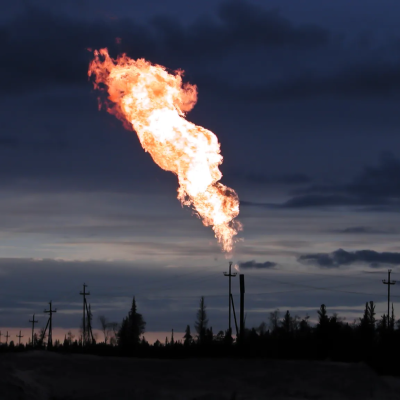
Mapping Methane Emissions from Fossil Fuel Exploitation
Scientists map 97 million metric tons of methane emissions from the exploitation of oil, natural gas, and coal.
Data in Action: GES DISC data resources for research on the massive Tonga volcanic eruption
NASA's Goddard Earth Sciences Data and Information Services Center (GES DISC) features numerous datasets that researchers can utilize to investigate the atmospheric effects of the Hunga Tonga–Hunga Haʻapai blast that took place January 15, 2022.
Data in Action: Signature of the Shamal
The Shamal wind blows in one direction, and desert dust shows when and where it blows.
Data in Action: Finding Dukono
The active Dukono volcano is on a remote Indonesian island, but its general location can be determined from space by its sulfur dioxide "signature."
Data in Action: MODIS Captures Indirect Impacts of COVID-19 on the Environment
Researchers from the Department of Mining Engineering at the National Institute of Technology in Rourkela, India, used daily 1 km Combined Terra and Aqua Moderate Resolution Imaging Spectroradiometer (MODIS) Land Aerosol Optical Depth (AOD) (MCD19A2) data from 2000 to 2020 to assess the impact of the pandemic-triggered lockdowns on the AOD level as an indicator of air pollution.
ATom: Cloud and Coarse Aerosol Measurements, 2016-2018
NASA's Oak Ridge National Laboratory DAAC (ORNL DAAC) recently released this dataset that is part of the Atmospheric Tomography Mission (ATom).
Webinars
NASA Earthdata Webinars span the Earth science disciplines and are designed to help users learn about NASA Earth observing data, services, and tools and show users how to work with these resources.
- Learn How to Access and Acquire NASA Level-1 MODIS and VIIRS Data and Atmosphere Products from LAADS DAAC
- Powered Up Data—Getting to Know the Sub-Orbital Order Tool (SOOT) Power User Interface
- NASA Worldview—Explore the Earth from Past to Present with Global Satellite Observations
- A Clearer View of the Haze – Using NASA GES DISC Data Tools to Examine the June 2020 Sahara Dust Event over Barbados
- Learn How to Discover, Access, and Customize Multiple Datasets Using Earthdata Search
- Discover NASA’s Near Real-Time Data using LANCE
- Remote Sensing Derived Environmental Indicators for Decision Making
Data Recipes and Tutorials
Data recipes are step-by-step instructions for using and working with Earth science data, information, tools, and services. Tutorials cover many different data products across the Earth science disciplines and different data discovery and data access tools, including programming languages and related software.
- Data Recipes at NASA's Goddard Earth Sciences Data and Information Services Center (GES DISC)
- Data Recipes at NASA's Global Hydrometeorology Resource Center DAAC (GHRC DAAC)
- Tutorials at NASA's Level-1 and Atmosphere Archive and Distribution System DAAC (LAADS DAAC)
- Data Recipes at NASA's Oak Ridge National Laboratory DAAC (ORNL DAAC)
Additional NASA Resources
Air quality and atmospheric composition are components of many airborne and field investigations. The web-based Catalog of Archived Suborbital Earth Science Investigations (CASEI) facilitates quick access to detailed information about NASA’s airborne and field investigations along with links to associated data products. CASEI was developed by NASA’s Airborne Data Management Group (ADMG). ADMG is part of NASA’s Interagency Implementation and Advanced Concepts Team (IMPACT), which is an ESDS Program component.

NASA's Applied Sciences Program works with partners around the world to use NASA's unique view from space to inform decision-making, enhance quality of life, and strengthen local economies. Air quality-related efforts can be found on the Applied Sciences Health & Air Quality program area webpage, while the Applied Sciences' Applied Remote Sensing Training (ARSET) Program provides training focusing on remote sensing applications for health and air quality. Another Applied Sciences-supported resource is the NASA Health and Air Quality Applied Sciences Team (HAQAST). HAQAST uses NASA satellite data to help solve real-world public health and air quality problems around the world. Headquartered at the University of Wisconsin-Madison, its members are spread across the U.S. in government offices and public and private universities.
Air quality information also is available through the Global Learning and Observations to benefit the Environment (GLOBE) Program. GLOBE is an international science and education program that provides students and the public opportunities to meaningfully contribute to our understanding of the Earth system and the global environment. NASA is the lead agency for GLOBE, with the U.S. State Department, NOAA, and the National Science Foundation as partners. GLOBE resources related to air quality include:
Other NASA resources for air quality information are:
- NASA Air Quality Observations from Space
- NASA Earth Observatory air quality articles
- NASA Scientific Visualization Studio air quality visualizations