Image

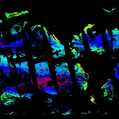
Land surface reflectance is a measure of the fraction of incoming solar radiation reflected from Earth's surface to a satellite-borne or aircraft-borne sensor. It is useful for measuring the greenness of vegetation, which can then be used to determine phenological transition dates including the start of the growing season, the period of peak growth, and the end of the growing season. Agricultural production estimates must be restricted to crop-specific areas to avoid confusion with other crops, natural vegetation, and areas of no vegetation. This allows specific crops to be followed through time with continued observations using sustained land imaging and multi-spectral high-resolution imagery.
The Advanced Spaceborne Thermal Emission and Reflection Radiometer (ASTER) instrument aboard NASA's Terra satellite is a high-resolution instrument that acquires visible and near-infrared (VNIR) reflectance data at 15 m spatial resolution and short wave infrared (SWIR) reflectance data at 30 m spatial resolution. A cooperative effort between NASA and Japan's Ministry of Economy Trade and Industry, ASTER data are distributed by NASA's Land Processes Distributed Active Archive Center (LP DAAC). As a tasked sensor, ASTER acquires data when it is directed to do so over specific targets. This makes its temporal resolution variable depending on the requested target region of interest. ASTER surface reflectance products are processed on-demand and can be requested through Earthdata Search (NOTE: there is a limit of 2,000 granules per order):
- ASTER Level 1 Precision Terrain Corrected Registered At-Sensor Radiance Version 3.1 (AST_L1T) data products
- Higher level ASTER data products
The Enhanced Thematic Mapper (ETM+) sensor and the Operational Land Imager (OLI) instruments aboard the joint NASA/USGS Landsat 7 (ETM+) spacecraft and Landsat 8 (OLI) spacecraft acquire VNIR data at 30 m spatial resolution every 16 days (less days as you move away from the equator). Landsat 9 is scheduled for launch in September 2021 and carries two instruments: the OLI-2 (which is a copy of the Landsat 8 OLI) and the Thermal Infrared Sensor-2 (TIRS-2, which measures land surface temperature in two thermal infrared bands). Landsat satellite operations and data archiving are coordinated at the USGS Earth Resources Observation and Science (EROS) Center, which also is the location of LP DAAC.
Research quality land surface reflectance data products can be accessed directly using Earthdata Search (note: you will need a USGS Earth Explorer login—which is separate from the NASA Earthdata Login—to download Landsat data):
Image

Another high-resolution land surface reflectance imagery option is Harmonized Landsat Sentinel (HLS)-2 imagery. HLS imagery provides consistent surface reflectance and top of atmosphere brightness data from the OLI aboard Landsat 8 and the Multi-Spectral Instrument (MSI) aboard the European Space Agency Sentinel-2A and -2B satellites. The harmonized measurement enables global land observations every 2-3 days at 30 m spatial resolution. HLS data are currently provisional and not considered standard data products. A science quality HLS dataset is expected to be released in fall 2021.
- HLS Surface Reflectance imagery from Earthdata Search
- HLS Surface Reflectance imagery in NASA Worldview
The Application for Extracting and Exploring Analysis Ready Samples (AppEEARS) tool, available through LP DAAC, offers a simple and efficient way to access, transform, and visualize geospatial data from a variety of federal data archives, including the USGS Landsat Analysis Ready Data (ARD) surface reflectance product. Landsat ARD are for Landsat Collection 1 and are available for the conterminous U.S., Alaska, and Hawaii using Landsat 8 OLI/Thermal Infrared Sensor (OLI/TIRS), Landsat 7 ETM+, and Landsat 4 and 5 Thematic Mapper (TM) data.
Image

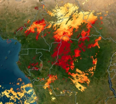
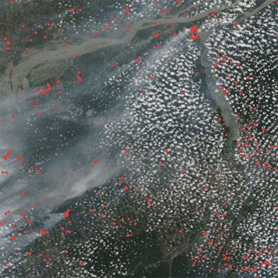
Deforestation for agriculture and livestock production contributes to land degradation. Through the SDGs, the UN advocates for sustainable land management, which seeks to maintain vegetative cover and health as well as make efficient use of water, nutrients, and pesticides. Land cover is one of the indicators that can help quantify land degradation.
The Moderate Resolution Imaging Spectroradiometer (MODIS) Terra and Aqua Land Cover Type data product (MCD12Q1) provides global land cover types at yearly intervals. This product is derived using supervised classifications of MODIS Terra and Aqua surface reflectance data. The supervised classifications then undergo additional post-processing that incorporates prior knowledge and ancillary information to further refine specific land type classes. Land cover types are based on the International Geosphere-Biosphere Programme classification scheme. These data can be accessed and downloaded through Earthdata Search and NASA Worldview:
LP DAAC provides access to three products related to agricultural land cover types:
- Global Food Security-support Analysis Data 30 meter (GFSAD30) Cropland Extent data product
- Global Hyperspectral Imaging Spectral-library of Agricultural (GHISA) crops
- Conterminous United States (GHISACONUS)
- Central Asia (GHISACASIA)
The GFSAD30 collection provides global cropland extent data that are divided and distributed into seven separate regional datasets for the year 2015 (2010 for North America) at 30 m resolution. These datasets are an important resource for policymaking and provide baseline data that are used in many agricultural cropland studies pertaining to water sustainability and food security.
GHISACONUS provides dominant crop data (rice, corn, soybeans, cotton, and winter wheat) based on hyperspectral data from the Hyperion instrument aboard NASA's Earth Observing-1 satellite (EO-1, operational 2000 to 2017). Crop growth states (emergence/very early vegetative, early and mid-vegetative, late vegetative, critical, maturing/senescence, and harvest) for the major agricultural crops are included in the spectral library. GHISACASIA provides dominant crop data (wheat, rice, corn, alfalfa, and cotton) in different growth stages across the Galaba and Kuva farm fields in the Syr Darya river basin in Central Asia. The GHISA hyperspectral library for the two irrigated areas was developed using EO-1 Hyperion hyperspectral data acquired in 2007 and Analytical Spectral Devices, Inc. (ASD) Spectroradiometer data acquired in 2006 and 2007.
Image

The USDA interactive CropScape tool provides crop-specific land cover data layers created annually for the continental U.S. using moderate resolution satellite imagery, specifically from Landsat, and extensive agricultural validation from ground-based measurements. The USDA Crop Explorer provides global information by region or by crop commodity.
The University of Maryland worked with NASA and the USDA to create the original Global Inventory Modeling and Mapping Studies Global Agriculture Monitoring System. Recognizing the emergence of new needs for agricultural monitoring along with better technology and computing power, the Global Agriculture Monitoring system 2 (GLAM 2) was developed by NASA Harvest. NASA Harvest operates as a consortium of over 40 global partners that work to enable and advance adoption of satellite Earth observations by public and private organizations to benefit food security, agriculture, and human and environmental resiliency in the U.S. and worldwide.
NASA Harvest GLAM 2 is a near real-time monitoring of global croplands that enables global users to track crop conditions as growing seasons unfold. Since GLAM data processing is cloud-based and does not rely on local bandwidth to compile datasets, users can access the publicly available web interface from anywhere in the world. New functions, such as custom time series charts, cropland, and crop type masks, recently have been implemented.
Image

Land Surface Temperature (LST) describes processes such as the exchange of energy and water between the land surface and Earth's atmosphere and influences the rate and timing of plant growth. LST data can improve decision-making for water use and irrigation strategies.
Research quality LST data products can be accessed directly from Earthdata Search and also are available through the Data Pool at LP DAAC. LST data acquired by the MODIS and ASTER instruments are available in HDF format; data from the VIIRS and ECOSTRESS instruments are available in HDF5 format:
- Terra MODIS LST
- Aqua MODIS LST
For both MODIS products, select daily, 8-day, or monthly at 1 km or 5.6 km resolution. For more information on spatial and temporal resolution, see the Earthdata Backgrounder What is Remote Sensing? - Terra MODIS LST/3-Band Emissivity
- Aqua MODIS LST/3-Band Emissivity
For both of these MODIS products, select 5-min, daily, and 8-day at 1 km resolution. - VIIRS LST/3-Band Emissivity
Choose daily or 8-day at 1 km resolution. - ASTER Surface Kinetic Temperature
ASTER surface temperature products are processed on-demand and must be requested with additional parameters. Note that there is a limit to 2,000 granules per order. - ECOSTRESS LST
To quickly extract a subset of ECOSTRESS, MODIS, or VIIRS data for a region of interest, use AppEEARS available through LP DAAC, or the subsetting tools available through ORNL DAAC. See the Tools for Data Access and Visualization section for additional information on both of these tools.
LST data can be visualized and interactively explored using NASA Worldview:
LST data also are produced as part of the joint NASA/USGS Landsat series of Earth observing missions (note: you will need a USGS Earth Explorer login—which is separate from NASA's Earthdata Login—to download Landsat data):
Image

Vegetation indices measure the amount of green vegetation over a given area and can be used to assess vegetation health. Commonly used vegetation indices are the Normalized Difference Vegetation Index (NDVI) and the Enhanced Vegetation Index (EVI) and EVI2.
The NDVI takes the difference between near-infrared (NIR) and red reflectance divided by their sum. NDVI values range from -1 to 1. Low values of NDVI generally correspond to barren areas of rock, sand, exposed soils, or snow. Higher NDVI values indicate greener vegetation, including forests, croplands, and wetlands. The EVI minimizes canopy-soil variations and improves sensitivity over dense vegetation conditions.
New animations by NASA's Science Visualization Studio show NDVI anomalies over time globally and for selected regions:
- A Global view of Normalized Difference Vegetation Index (NDVI) Anomaly in crop-growing regions from 2000 to 2021 shows the NDVI anomaly between 2000 and 2021 in areas where maize, rice, soybeans, summer wheat, or winter wheat are grown.
- Normalized Difference Vegetation Index (NDVI) Anomaly in crop-growing regions for selected years shows the NDVI anomaly in areas where maize, rice, soybeans, summer wheat, or winter wheat are grown in the U.S., Australia, Russia, Europe, and southern Africa for the years 2000 to 2021.
Vegetation products created from data acquired by the MODIS instrument aboard the Terra and Aqua satellites and the Visible Infrared Imaging Radiometer Suite (VIIRS) instrument aboard the joint NASA/NOAA Suomi National Polar-orbiting Partnership (Suomi NPP) satellite can be accessed in several ways. Research quality surface reflectance data products can be accessed directly using Earthdata Search (datasets are available as HDF files but are, in some cases, customizable to GeoTIFF):
AppEEARS, available through LP DAAC, offers a simple and effective way to extract, transform, visualize, and download vegetation-related data products produced from data acquired by the MODIS and VIIRS instruments. AppEEARS allows users to subset data by defining specific points or areas of interest. Output data can be downloaded in CSV (point), GeoTIFF (area), or NetCDF4 (area) formats.
LP DAAC's Getting Started with Cloud-Native Harmonized Landsat Sentinel (HLS) Data in Python Jupyter Notebook shows how to extract an EVI Time Series from HLS imagery. In addition, MODIS and VIIRS subsetting tools available through NASA's Oak Ridge National Laboratory DAAC (ORNL DAAC) provide a means to simply and efficiently access MODIS and VIIRS vegetation-related data products. See the Tools for Data Access and Visualization section for additional information about these tools.
Data products can be visualized as a time-averaged map, an animation, seasonally-averaged maps, scatter plots, or a time series using an online interactive data analysis tool called Giovanni. Follow these steps to plot data in Giovanni: 1) Select a visualization type. 2) Select a date range. Data are available in multiple temporal resolutions, so be sure to note the resolution and the start and end dates of datasets to ensure you can analyze the desired data. 3) Select a region of interest using a bounding box, shapefile, or geographic coordinates. 4) Check the box of the variable in the left column that you would like to include and then plot the data. For more information on choosing a plot type, region of interest, and data variables, see the Giovanni User Manual.
- MODIS NDVI in Giovanni
Select a map plot, date range, and region and plot the data. Data can be downloaded as GeoTIFF.
Near real-time imagery can be interactively explored using NASA Worldview:
- MODIS NDVI
This dataset has a spatial resolution of 250 m and the temporal resolution is an 8-day product, updated daily. 16-day and monthly data are also available in Worldview. - MODIS EVI
This dataset is monthly at 1 km spatial resolution. Rolling 8-day and 16-day data are also available in Worldview.
MODIS NDVI is also available through geospatial web map services. For information on accessing the data within a GIS program, see the Biosphere Geospatial Services section in the Earthdata GIS Data Pathfinder.
Image

Gross primary productivity (GPP) is the total energy captured by vegetation. Net primary productivity (NPP) is the amount of carbon dioxide (CO2) vegetation takes in during photosynthesis minus how much CO2 is released during plant respiration. Values typically range from 0 to 6.5 grams per square meter per day. A negative value indicates decomposition or that respiration overpowered carbon absorption, that is, more carbon was released to the atmosphere than was taken in. Estimates of GPP provide valuable information about the spatial distribution and temporal variability of primary production, which in an agricultural setting determines crop yields and fodder production for animals.
Level 4 GPP and NPP products produced from data acquired by the MODIS instrument aboard the Terra and Aqua satellites are available in yearly and 8-day temporal resolutions with 1 km or 500 m pixel size using Earthdata Search:
AppEEARS, available through LP DAAC, offers a simple and effective way to extract, transform, visualize, and download vegetation-related data products produced from data acquired by the MODIS and VIIRS instruments. AppEEARS allows users to subset data by defining specific points or areas of interest. Output data can be downloaded in CSV (point), GeoTIFF (area), or NetCDF-4 (area) formats.
In addition, MODIS and VIIRS subsetting tools available through ORNL DAAC, provide a means to access and visualize MODIS and VIIRS GPP and NPP data products simply and efficiently. See the Tools for Data Access and Visualization section for additional information about these tools.
Image

Evapotranspiration (ET) is the sum of evaporation from land surface and transpiration in vegetation. ET measurements are extremely useful in monitoring and assessing water availability, drought conditions, and crop production. An increase inavailable energy through changes in cloud cover, seasonal lengthening of daylight, and similar variables favors carbon assimilation through photosynthesis (primary production) and also increases ET. This, in turn, extracts available water from the soil and represents the largest component of consumptive water use in the U.S. If this soil water is not replenished through rain or irrigation, plants close their stomata to conserve water and primary production is reduced. By comparing observed ET to a modeled expectation of crop water requirements, ET observations can be used to schedule irrigation applications and improve agricultural water management.
One of the issues in acquiring ET data is that ET can't be measured directly with satellite instruments as it is dependent on variables including land surface temperature, air temperature, and solar radiation. However, NASA has Level 4 data products that incorporate daily meteorological reanalysis data with remote sensing data to arrive at estimations of ET, such as the Moderate Resolution Imaging Spectroradiometer (MODIS) MOD16 product.
Research quality MODIS Level 4 ET products are available in yearly and 8-day temporal resolutions with 500 m pixel size and can be accessed using Earthdata Search:
Image

NASA's ECOsystem Spaceborne Thermal Radiometer Experiment on Space Station (ECOSTRESS) aboard the International Space Station measures the temperature of plants to better understand how they respond to the stress of insufficient water availability. ECOSTRESS was installed in June 2018 and uses a multispectral thermal infrared radiometer to measure radiance, which is converted into surface temperature and emissivity.
Research quality ECOSTRESS ET data products can be accessed directly using Earthdata Search or the Data Pool at LP DAAC. Datasets are available as HDF files but are, in some cases, customizable to GeoTIFF:
AppEEARS, available through LP DAAC, offers a simple and effective way to extract, transform, visualize, and download MODIS and ECOSTRESS ET data products. AppEEARS allows users to subset data by defining specific points or areas of interest. Output data can be downloaded in CSV (point), GeoTIFF (area), or NetCDF-4 (area) formats.
In addition, MODIS and VIIRS subsetting tools available through ORNL DAAC, provide a means to simply and efficiently access and visualize MODIS ET data products. See the Tools for Data Access and Visualization section for additional information about these tools.
NASA's Land Data Assimilation System (LDAS) provides model-based ET data and includes a global collection (GLDAS) and a North American collection (NLDAS). LDAS uses measurements of precipitation, soil texture, topography, and leaf area index (LAI) to model soil moisture and ET. When calculating ET, there are biases around seasonality or local-specific effects, but the model developers try to account for these and calibrate accordingly. Estimates of ET are provided every day and integrated to get monthly, seasonal, or annual information within 2-12% error.
GLDAS data products can be visualized as a time-averaged map, an animation, seasonally-averaged maps, scatter plots, or a time series through an online interactive data analysis tool called Giovanni. Follow these steps to plot data in Giovanni: 1) Select a plot type. 2) Select a date range. Data are in multiple temporal resolutions and multiple temporal coverages, so be sure to note the start and end date to ensure you can analyze the desired data. 3) Select a region of interest using a bounding box, shapefile, or geographic coordinates. 4) Check the box of the variable in the left column that you would like to include and then plot the data. Maps and plots for multiple variables can be generated at the same time. For more information on choosing a type of plot, see the Giovanni User Manual.
- GLDAS ET in Giovanni
Data are available with a temporal resolution of 3-hourly, daily, and monthly.
OpenET is a new web-based platform that puts openly-available ET data in the hands of farmers, water managers, and conservation groups to speed up improvements and bring about innovation in water management across 17 states in the Western U.S. It uses publicly-available data and open-source models to deliver satellite-based ET information in areas as small as a quarter of an acre and at daily, monthly, and yearly intervals. OpenET was developed through a unique public-private partnership led by NASA, the Desert Research Institute (DRI), and the Environmental Defense Fund (EDF), with in-kind support from Google Earth Engine. The OpenET Team also includes scientists and software engineers from the U.S. Geological Survey, U.S. Department of Agriculture, HabitatSeven, California State University Monterey Bay, University of Idaho, University of Maryland, University of Nebraska-Lincoln, UCLA, and Universidade Federal do Rio Grande do Sul in Brazil.
Image

The Evaporative Stress Index (ESI) describes temporal anomalies in evapotranspiration (ET) and highlights areas with anomalously high or low rates of water use across the land surface. ESI also demonstrates the capability for capturing early signals of "flash drought" brought on by extended periods of hot, dry, and windy conditions that can lead to rapid soil moisture depletion. ESI data can be used to assess agricultural drought and observe vegetation stress.
Level 4 ESI and water use efficiency (WUE) products created from data, collected by ECOSTRESS, can be accessed using Earthdata Search. The ESI product is derived from the ratio of Level 3 actual ET to potential ET (PET), calculated as part of an algorithm. WUE is the ratio of carbon stored by plants to water evaporated by plants. This ratio is given as grams of carbon stored per kilogram of water evaporated over the course of the day from sunrise to sunset on the day when the ECOSTRESS data granule is acquired.
AppEEARS, available through LP DAAC, offers a simple and effective way to extract, transform, visualize, and download ECOSTRESS Level 1 through Level 4 data products. AppEEARS allows users to subset data by defining specific points or areas of interest. Output data can be downloaded in CSV (point), GeoTIFF (area), or NetCDF-4 (area) formats. See the Tools for Data Access and Visualization section for additional information about this tool.
Image

NASA's Precipitation Measurement Missions (PMM) provide a more than 22-year continuous record of precipitation data through the Tropical Rainfall Measuring Mission (TRMM; operational 1997 to 2015) and the Global Precipitation Measurement mission (GPM; launched in 2014). GPM, the TRMM successor mission, provides more accurate measurements, improved detection of light rain and snow, and extended spatial coverage.
Data products from TRMM and GPM are available individually and have been integrated with data from a global constellation of satellites of opportunity to yield precipitation estimates with improved spatial coverage and temporal resolution. The first integrated product was the TRMM Multi-satellite Precipitation Analysis (TMPA), which has now been superseded by the Integrated Multi-satellitE Retrievals for GPM (IMERG). IMERG's multiple runs accommodate different user requirements for accuracy and latency (Early = 4 hours, e.g., for flash flood events; Late = 12 hours, e.g., for crop forecasting; and Final = 3 months, with the incorporation of rain gauge data, for research). Along with Earthdata Search, IMERG data are available through the GPM website.
In addition to the precipitation products developed by NASA's PMM, NASA's Hydrological Sciences Laboratory, in collaboration with other agencies, has developed land surface models incorporating satellite precipitation estimates with ground-based data. These models are part of the Land Data Assimilation System (LDAS), which includes a global collection (GLDAS) and a North American collection (NLDAS). LDAS uses inputs of measurements including precipitation, soil texture, topography, and leaf area index to model high quality fields of land surface states (e.g., soil moisture, temperature) and fluxes (e.g., evapotranspiration, runoff).
GLDAS has a spatial resolution of 1 degree and 0.25 degrees, with data available for all land north of 60 degrees south latitude. GLDAS data are available from January 1948 to present. NLDAS is currently running operationally in near real-time (with an approximate four-day lag) on a 1/8th-degree grid with an hourly time step over central North America (between approximately 25 to 53 degrees north latitude and -125 to -67 degrees west longitude). Retrospective hourly/monthly NLDAS datasets are available from January 1979 to present.
Image
")
The Famine Early Warning Systems Network (FEWS NET) Land Data Assimilation System (FLDAS) is a custom instance of the NASA Land Information System (LIS) that has been adapted to work with domains, data streams, and monitoring and forecast requirements associated with food security assessment in data-sparse, developing-country settings. Adopting LIS allows FEWS NET to leverage existing land surface models and generate ensembles of soil moisture, evapotranspiration (ET), and other variables based on multiple meteorological inputs or land surface models. The goal of the FLDAS project is to achieve more effective use of limited available hydroclimatic observations. FLDAS data have a spatial resolution of 0.1 degrees and are available for all land north of 60 degrees south latitude. Daily FLDAS data are available in 15-minute time steps with an available data record starting in January 1981.
Various NASA precipitation products can be visualized as time-averaged maps, animations, seasonally-averaged maps, scatter plots, or time series using an online interactive data analysis tool called Giovanni. Follow these steps to plot data in Giovanni: 1) Check the box of the variable in the left column you want to include. 2) Select a plot type. 3) Select a date range (data are available in multiple temporal resolutions, so be sure to note the resolution and the start and end dates of datasets to ensure you can analyze the desired data). 4) Select a region of interest using a bounding box, shapefile, or geographic coordinates. 5) Plot the data. Maps and plots for multiple variables can be generated at the same time. For more information on choosing a type of plot, see the Giovanni User Manual.
Near real-time data can be visualized and interactively explored using NASA Worldview:
- IMERG Precipitation Rate
- NLDAS Precipitation Total
- GLDAS Precipitation Total (only goes through 2010)
Another NASA source for precipitation data is Daymet, which can be accessed through ORNL DAAC. Daymet is a collection of gridded estimates of daily weather parameters including minimum and maximum temperature, precipitation, vapor pressure, radiation, snow water equivalent, and day length at 1 km resolution over North America, Puerto Rico, and Hawaii. Daymet data are available from 1980 to present (North America and Hawaii) and from 1950 to present (Puerto Rico) and can be retrieved in a variety of ways, including: Earthdata Search; an API available through ORNL DAAC; ORNL DAAC tools; and through AppEEARS at LP DAAC. Along with daily data, annual Daymet climatologies also are available. See the Tools for Data Access and Visualization section for additional information about these tools.
Image

Water scarcity is a threat to many countries around the world. According to the UN, water use has been growing globally at twice the rate at which the global population is increasing. More and more areas are reaching the limit at which water services can be sustainably delivered, especially in arid regions. Groundwater, a major water resource for maintaining food security, is declining through the extensive use of water for agricultural irrigation, where aquifer recharge cannot keep up with groundwater extraction. Instruments aboard the joint NASA/German Space Agency (DLR) Gravity Recovery And Climate Experiment (GRACE, operational 2002 to 2017) and GRACE Follow-On (GRACE-FO, launched in 2018) satellites are obtaining measurements about changes in Earth's gravity that can be used to assess changes in water storage. Since water has mass, changes in groundwater storage can be detected as changes in gravity.
Data from GRACE and GRACE-FO are available from 2002 to present; the data track total water storage time-variations and anomalies (changes from the time-mean) at a resolution of approximately 90,000 km2 and larger. These measurements are unimpeded by clouds and track the entire land water column from the surface down to deep aquifers. GRACE and GRACE-FO data are uniquely valuable for regional studies to determine general trends in land water storage as well as for assessing basin-scale water budgets (e.g., the balance between precipitation, evapotranspiration, and runoff).
The GRACE and GRACE-FO Mascon Ocean, Ice, and Hydrology Equivalent Water Height dataset provides gridded monthly global water storage/height anomalies relative to a time-mean. The data are processed at NASA's Jet Propulsion Laboratory (JPL) using the mascon approach. Mass Concentration blocks (mascons) are a form of gravity field basis functions to which GRACE observations are optimally fit. For more information on this approach, see the JPL Monthly Mass Grids webpage. Data are represented as Water Equivalent Thickness (WET), which is a way of representing changes in the gravity field in hydrological units. WET represents the total terrestrial water storage anomalies from soil moisture, snow, surface water (including rivers, lakes, and reservoirs), as well as groundwater and aquifers.
Research-quality data products can be accessed using Earthdata Search. Datasets are available as NetCDF files that can be opened using NASA's Panoply data viewer or imported into a GIS system.
NASA's Physical Oceanography DAAC (PO.DAAC) has developed a Python script to convert the JPL GRACE Mascon file from netCDF4 to GeoTIFF format. This GRACE Python script decomposes the multi-year monthly mascon netCDF file into single GeoTIFF files for each month.
Image

GRACE and GRACE-FO data can be visualized and interactively explored using NASA Worldview and PO.DAAC's State of the Ocean (SOTO) data visualization tools. Both products incorporate a Coastal Resolution Improvement (CRI) filter that reduces leakage errors across coastlines.
Scientists at NASA's Goddard Space Flight Center use GRACE-FO data to generate weekly groundwater and soil moisture drought indicators. These are based on terrestrial water storage observations and are integrated with other observations using a sophisticated numerical model of land surface water and energy processes. The drought indicators describe current wet or dry conditions, expressed as a percentile showing the probability of occurrence for a specific location and time of year, with lower values (orange/red) indicating drier than normal conditions and higher values (blues) indicating wetter than normal conditions. The drought model is also used to make forecasts of expected drought conditions one, two, and three months into the future.
Billions of people worldwide rely on seasonal water runoff from snowpack and glaciers for irrigation and drinking water. The Indus Basin in Asia, for example, is the largest irrigation system in the world; snow melt from the Himalayan mountains is essential for rice production in the basin and contributes significantly to agricultural irrigation. Changes in global snow cover can have major impacts on food production.
Image

Snow Water Equivalent (SWE) is the amount of water contained in snowpack. It is analogous to melting the snow and measuring the depth of the resulting pool of water. SWE measurements are useful for assessing both the potential surface runoff from snow melt and the water availability for regions in lower elevations. Snow cover is one measurement acquired by the Moderate Resolution Imaging Spectroradiometer (MODIS) instrument aboard the Terra satellite. The Advanced Microwave Scanning Radiometer (AMSR) for EOS (AMSR-E) instrument aboard NASA's Aqua satellite and the AMSR2 instrument aboard the Japan Aerospace Exploration Agency's Global Change Observation Mission 1st–Water (GCOM-W1) spacecraft provide SWE data.
Research quality data products can be accessed using Earthdata Search (datasets are available as HDF5 files that can be opened using NASA's Panoply data viewer):
- MODIS Snow Cover
Data are available from 2000 to present in daily, 8-day, or monthly at various resolutions. Datasets are customizable to GeoTIFF. - AMSR-E SWE
Data are available from 2002 to 2011 in daily, 5-day, and monthly timeframes. Datasets are customizable to GeoTIFF. - AMSR2 SWE
Data are available from February 2018.
Near real-time data can be interactively explored using NASA Worldview:
Image

The Airborne Snow Observatory (ASO) mission collects data on snow melt flowing out of major water basins in the Western U.S. The mission began in April 2013 as a collaboration between JPL and the California Department of Water Resources, with weekly flights over the Tuolumne River Basin in California and monthly flights over the Uncompahgre River Basin in Colorado during the snow melt season; these data are available through Earthdata Search. Current data collection is undertaken by Airborne Snow Observatories, Inc., a private company working in partnership with Esri and the Weather Research and Forecasting Model Hydrological modeling system (WRF-Hydro) team of the National Center for Atmospheric Research.
Snow Today, available through the National Snow and Ice Data Center (NSIDC), is a NASA-supported scientific analysis website that provides a snapshot and interpretation of snow conditions in near real-time across the Western U.S. Snow Today updates daily images on snow conditions and relevant data and also provides monthly scientific analyses from January to May, or more frequently as conditions warrant. The NSIDC is part of the Cooperative Institute for Research in Environmental Sciences at the University of Colorado Boulder and the location of NASA's NSIDC DAAC.
Another NASA source for SWE data is Daymet, which can be accessed through ORNL DAAC. Daymet is a collection of gridded estimates of daily weather parameters including minimum and maximum temperature, precipitation, vapor pressure, radiation, snow water equivalent, and day length at 1 km resolution over North America, Puerto Rico, and Hawaii. Daymet data are available from 1980 to present (North America and Hawaii) and from 1950 to present (Puerto Rico) and can be retrieved in a variety of ways, including: Earthdata Search; an API available through ORNL DAAC; ORNL DAAC tools; and through AppEEARS at LP DAAC. Along with daily data, annual Daymet climatologies also are available. See the Tools for Data Access and Visualization section for additional information about these tools.
Image

Water availability, specifically with regard to soil moisture, is vital for crop growth and yield. Timely seasonal soil moisture information is critical for food security and provides the ability to detect drought and other water-related stressors on crop production.
NASA's Soil Moisture Active Passive satellite (SMAP, launched in 2015) measures the moisture in the top 5 cm of soil globally every 2-3 days at a resolution of 9-36 km. NASA, in collaboration with other agencies, has developed models of soil moisture content that incorporate satellite information with ground-based data (when ground-based data are available). These models are part of NASA's Land Data Assimilation System (LDAS), which includes a global collection (GLDAS) and a North American collection (NLDAS). LDAS takes inputs of measurements like precipitation, soil texture, topography, and leaf area index and uses these inputs to model output estimates of soil moisture and evapotranspiration.
Research quality SMAP data products can be accessed using Earthdata Search (datasets are available as HDF5 files which are also customizable to GeoTIFF):
Image
 is the daily average of measurements at 0-100 cm depth.")
The Soil Moisture Visualizer, which is available through ORNL DAAC integrates ground-based, SMAP, and other soil moisture data into a visualization and data distribution tool. AppEEARS, available through LP DAAC, offers a simple and effective way to extract, transform, visualize, and download SMAP data products. AppEEARS allows users to subset data by defining specific points or areas of interest. Output data can be downloaded in CSV (point), GeoTIFF (area), or NetCDF4 (area) formats. See the Tools for Data Access and Visualization section for additional information about these tools.
NLDAS and GLDAS data products can be visualized as a time-averaged map, an animation, seasonally-averaged maps, scatter plots, or a time series using an online interactive data analysis tool called Giovanni. Follow these steps to plot data in Giovanni: 1) Select a plot type. 2) Select a date range. Data are available in multiple temporal resolutions, so be sure to note the resolution and the start and end dates of datasets to ensure you can analyze the desired data. 3) Select a region of interest using a bounding box, shapefile, or geographic coordinates. 4) Check the box of the variable in the left column that you would like to include and then plot the data. Maps and plots for multiple variables can be generated at the same time. For more information on choosing a type of plot, see the Giovanni User Manual.
Near real-time SMAP imagery can be interactively explored using NASA Worldview:
Farmers, researchers, meteorologists, and other stakeholders have access to high-resolution NASA soil moisture data thanks to a tool developed by the U.S. Department of Agriculture's National Agricultural Statistics Service, NASA, and George Mason University. The Crop Condition and Soil Moisture Analytics (Crop-CASMA) geospatial application provides access to high-resolution data from the SMAP mission and from the MODIS instrument in an easy-to-use format.
Image

NASA's Socioeconomic Data and Applications Center (SEDAC) is NASA's Earth Observing System Data and Information System (EOSDIS) DAAC responsible for archiving and distributing socioeconomic data in the EOSDIS collection. SEDAC is hosted at Columbia University's Center for International Earth Science Information Network and serves as an "Information Gateway" between the socioeconomic and Earth science data and information domains.
SEDAC includes a number of data collections relevant to food security and agriculture, including:
- Past, present, and future population distribution
- Reservoirs and dams
- Agricultural land coverage/acreage/area
- Drought frequency and distribution
- Economic and mortality risks from natural disasters
- Flood frequency and distribution
- Food insecurity hotspots
- Agricultural pesticide use
- Nitrogen and phosphorus fertilizer application
- Global roads
- Environmental performance indicators
Agriculture and Food Security Data in Earthdata Search
Agriculture and Food Security Data at SEDAC
These datasets are available as GeoTIFFs or Esri Grid Files. Many of these datasets can be visualized using the SEDAC Map Viewer.
Water quality is as important to food production as water quantity but is harder to measure from space because many of its characteristics are invisible. Fresh, clean water is needed for agricultural production while fresh or salt water within a balanced, healthy ecosystem is critical for aquaculture as a sustainable food source. Agricultural practices that have increased use of fertilizers have led to more nitrogen and phosphorous runoff, which can lead to increased algal and plant growth that robs these aquatic ecosystems of oxygen, a condition called eutrophication. The Earthdata Water Quality Data Pathfinder provides more detailed information on the use of NASA data for assessing water quality in large water bodies along with links to these data.