Global Navigation Satellite System (GNSS)

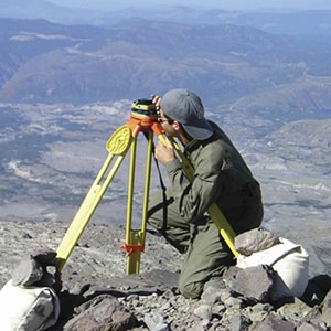
The Global Positioning System (GPS) is the U.S. version of a Global Navigation Satellite System (GNSS). A GNSS system like GPS has three components: satellites in well-known orbits with synchronized clocks, ground controllers, and a ground segment providing data to users. Using signals from four satellites, a precise location in three-dimensions (within millimeters or less) along with precise time can be determined. By comparing measurements over time, minute elevation and distance changes at a station can be calculated.

You Might Also Be Interested In

Filter By

Content type
Geese roam about on a typical farm in the Samara region in Russia.
Article
U.S. Navy officer Jonathan Myers explains to his colleague April Beldo how to use a marine sextant during a demonstration of celestial navigation.
Article
Image of icy mountains
Article
The April 2010 El Mayor-Cucapah earthquake revealed a previously undiscovered fault in the desert of Baja California, Mexico.
Article
Probes are buried in the ground at different depths to estimate soil moisture content
Article
This artist’s depiction shows the Mars Rover on the surface of Mars. Because of precise information about Earth’s length of day and orientation, NASA was able to directly land the Rover on Mars.
Article
A researcher checks the calibration of a ground-mounted Global Positioning System (GPS) station on Mount St. Helens.
Article