IMPACT will make an appearance at this year’s meeting of the American Geophysical Union in December. This year’s conference is a hybrid of in-person presentations in New Orleans, Louisiana and virtual talks. Here is the first of several previews of the presentations IMPACT team members will make at AGU.
Elizabeth Fancher will present on enabling cross-disciplinary collaborations in her presentation “Advancing Open Science through Public-Private Partnerships”. The concept of science-at-scale is becoming ever more salient given the manner in which rapid technology developments are changing the way data-driven research is performed within the science community. In this context cloud computing is increasingly a viable approach for enabling scalable science. Cloud infrastructures allow data to be relocated out of institutional silos and onto computational platforms that make data and tools accessible to all users. As a result, researchers are not hindered by obstacles of data management and data wrangling, allowing them to quickly discover, access and perform analysis on extremely large datasets.
IMPACT establishes Space Act Agreements with selected partners from the public-private sector working in the area of cloud computing in order to explore new opportunities with commercial cloud providers to accelerate open science and enable discovery, access and use of data sets on the cloud. These partnerships also help establish training workshops for the science community to assist researchers utilizing the cloud for science. In this talk, Ms. Fancher will present an overview of current and new partnerships IMPACT is developing to support open science and open data initiatives.
Jenny Wood will present on an innovative solution for automating metadata review processes. Her presentation “pyQuARC: Open Source Library for Earth Observation Metadata Quality Assessment” addresses the need for attention to metadata as a best practice for maintaining research data repositories. As the number of Earth science datasets continues to increase, ensuring the quality of the associated metadata is essential to effective data discovery.
The metadata describing NASA’s Earth observation data products resides in the Common Metadata Repository (CMR). The Analysis and Review of CMR (ARC) Team, located at Marshall Space Flight Center, conducts metadata quality assessments to ensure that these data products are discoverable, accessible, and usable. To achieve these goals, the ARC team developed a metadata quality assessment framework to evaluate metadata completeness, correctness, and consistency. ARC uses a combination of manual and automated methods to assess these three components and identify areas of improvement.
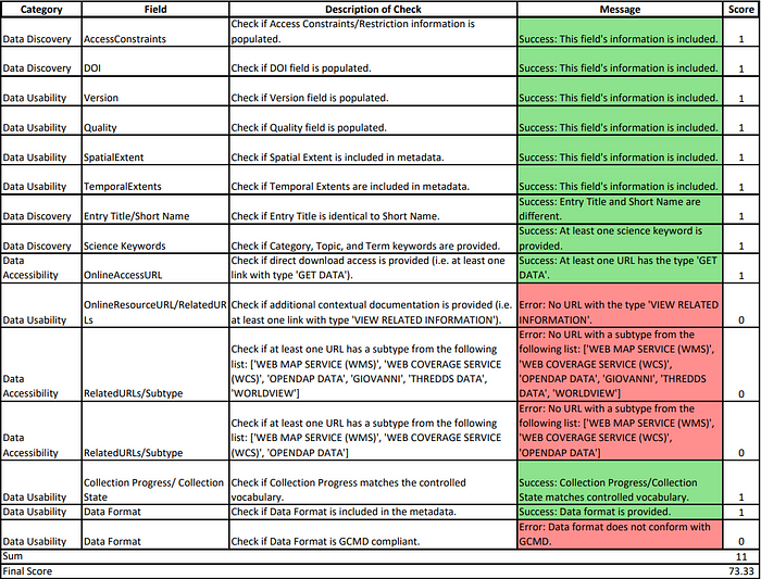
To streamline this process, ARC is currently developing a host of python scripts, known as pyQuARC, to automate metadata quality assessments as much as possible. pyQuARC is an open source library for Earth observation metadata quality assessment. It utilizes ARC’s metadata quality assessment framework to make basic validation checks, pinpoint inconsistencies between dataset-level and file-level metadata, and identify opportunities for more descriptive and robust information.
pyQuARC is a customizable set of python scripts. Users can make modifications as needed and implement additional metadata standards. Once pyQuARC is fully developed, it will support multiple schema types to serve the broader NASA EOSDIS metadata community. This presentation will provide an overview of pyQuARC and its process of development while showcasing the tool’s valuable features and uses.