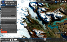
The Advanced Baseline Imager (ABI) is the primary instrument aboard the GOES-R Series for imaging Earth’s weather, oceans, and environment. ABI views Earth with 16 different spectral bands (compared to five on the previous generation of GOES), including two visible channels, four near-infrared channels, and 10 infrared channels. These different channels (wavelengths) are used by models and tools to indicate various elements on Earth’s surface or in the atmosphere, such as trees, water, clouds, moisture, or smoke.
Image