The air we breathe provides a blend of elements essential for people and animals to live on Earth. The air can also contain a mix of pollutants and greenhouse gases that threaten our very health and survival.
“It's no secret that human health and air quality are closely linked, and at NASA, we understand the importance of monitoring the vital signs of our home planet, including the quality of the air in the atmosphere that we, as humans, breathe,” said Joel Scott, program executive for NASA’s Earth Science Data Systems (ESDS) Program.
To address the threats of air pollution and other exposure hazards, NASA formed the Health and Air Quality Applied Sciences Team (HAQAST) with the goal of connecting health and air quality experts and community-serving organizations with NASA Earth science data and tools to solve their real-world problems. HAQAST’s work also helps to spread awareness of these data among scientists, support decision-making, provide technical feedback on NASA’s data products, create and test new products, and identify future data needs among researchers and communities.
NASA’s Earth Science Division and ESDS work closely together to support the HAQAST program. The Earth Science Division solicits proposals for community members to join HAQAST and offers funding for member projects; ESDS supplies unrestricted air quality data from a wide range of missions along with the tools for analyzing and working with these data.
“ESDS ingests, processes, archives, and then distributes the valuable data that NASA's Earth-observing satellites collect to researchers, to decision-makers, and to the public to use in various efforts that improve the quality of life for humanity,” said Scott. “ESDS partners and closely works with HAQAST, whose researchers are working to ensure that cutting-edge Earth data and observations are being properly leveraged to support decision-making that enhances public and environmental health.”
Making the Teams
HAQAST is comprised of researchers with expertise ranging from epidemiology to remote sensing who all have various levels of familiarity with using NASA Earth science data. Researchers apply to be on HAQAST to complete their own community-engaged health or air quality applied research projects as well as to collaborate on work with others over the course of four years.
HAQAST began as NASA’s Air Quality Applied Science Team (AQAST), which ran from 2011 to 2016. NASA added the emphasis on health for the first edition of HAQAST, which ran from 2016 to 2020. The current 2021 to 2025 version of HAQAST includes 14 air quality and public health principal investigators (PIs).
PIs not only conduct their own research, they also partner with other PIs and co-investigators to lead two different types of teams: Rapid Response Teams and Tiger Teams.
Rapid Response Teams lead initiatives to solve health and air quality issues that require urgent attention and take a year or less to complete. For example, HAQAST is conducting a data fusion and machine learning project to improve wildfire smoke forecasts in Alaska. The project is integrating machine learning with low-cost ground sensors, satellite data, and air quality models. These data will be shared through different platforms, including mobile apps, to provide access to the general public.
Tiger Teams are longer, multi-year, high-impact, collaborative projects involving HAQAST members and public stakeholders to identify and solve an immediate problem using NASA data and products. Each Tiger Team draws on the expertise of multiple HAQAST PIs to find the best, multifaceted solutions to pressing health and air quality issues. HAQAST Tiger Team projects range from using satellite data to assess the efficacy of environmental regulations on air quality to identifying oil and gas extraction sites that are hot spots for the release of air pollutants and greenhouse gasses.
Project ideas come from a combination of PI interests, NASA priorities, agency and organization requests, and stakeholder engagement.
“We brainstorm a lot at our bi-annual public meetings,” said Jenny Bratburd, HAQAST’s outreach coordinator based at the University of Wisconsin-Madison. “These ideas then lead to proposals to form Tiger Teams that are led by HAQAST members and include the participation of community partners. The proposals are reviewed by stakeholders and the broader HAQAST community to get their input and feedback. We’re always making sure that partners are involved so that a project is going to be something that's useful for them and showcases the usefulness of NASA data and tools.”
Using Satellites to Seek Environmental Justice
Decades of research has convincingly shown that disadvantaged and vulnerable populations, such as people living in low-socioeconomic status areas, have disproportionately high burdens of hazardous environmental exposures—a key contributor to health inequity. Satellite and other related data can reveal wide-spread, high-concentration, or previously undetected and dangerous exposures to air, light, and other pollutants that place people at risk. With this in mind, HAQAST is currently running its second phase of an Environmental Justice Tiger Team to build capacity among the environmental justice community for using and interpreting satellite datasets. The team is currently led by Dr. Qian Xiao, an associate professor of epidemiology and disease control with the UTHealth School of Public Health in Houston, TX.
“This work is near and dear to my heart as a public health researcher because we're trying to understand how disparities in environmental exposure contribute to health disparities in human populations,” said Xiao.
The Tiger Team is working on a wide range of projects initiated by agencies and stakeholders, such as a literature review project on multipoint environmental exposures in collaboration with the Environmental Justice Index team at the Centers for Disease Control and Prevention (CDC) and an Environmental Defense Fund project seeking to use satellite data to measure air pollution, noise, and light exposure at night. The team holds open monthly meetings and routinely shares communications with more than 200 researchers, decision-makers, and other interested parties.
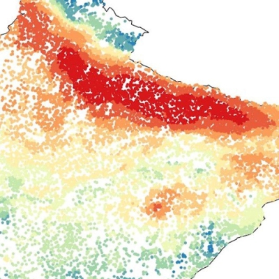
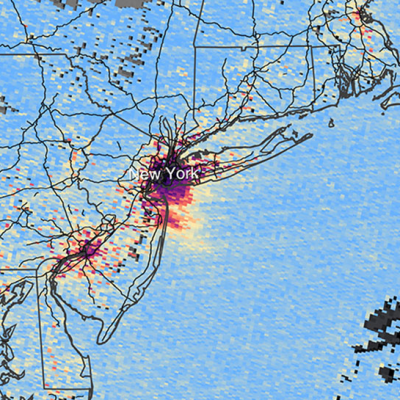
Xiao is also collaborating with the Adler Planetarium in Chicago on a community-oriented project focusing on light pollution in low-income areas of the city using data from NASA’s Black Marble project.
“Exposure to bright light at night disrupts the human body’s circadian rhythm, which can lead to sleep deficiency and cascading health affects such as mood disorders, obesity, and cancer,” said Xiao. “Low-income areas tend to be brightly lit because they are often in the urban core of cities and residents do not always have the knowledge and resources to reduce light pollution in their neighborhoods and homes.” This light pollution then places residents at an increased risk for illness. Xiao and the Tiger Team are using satellite data to identify low-income areas with high light pollution so that public health professionals and officials can create policies and programs to limit the use of excessive lighting.

HAQAST Public Meeting, October 19-20
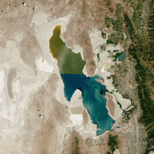
With light pollution and other issues in mind, HAQAST members will share their insights, expertise, and discoveries during the organization’s upcoming public hybrid meeting October 19-20 in Salt Lake City, Utah. The meeting will also offer a great opportunity for stakeholders to discuss their research needs and priorities with team members, which will help generate new collaborative project ideas for current or future editions of HAQAST.
By combining the power of earnest research and genuine community engagement with the broad, unique perspective of NASA’s Earth science data, HAQAST is making great advances in understanding and mitigating many environmental and atmospheric exposure hazards. Through HAQAST’s efforts we may—among many things—breathe easier, sleep better, and be healthier.