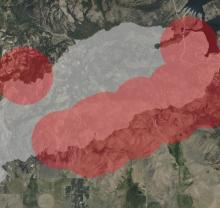
When Hurricane Ian swept through Florida, the impact was catastrophic. Roads, homes, schools, and other buildings were severely damaged or destroyed in the storm. To aid search and recovery efforts, University of Connecticut researchers from the Department of Natural Resources and the Environment Global Environmental Remote Sensing (GERS) Laboratory created the first high-resolution land disturbance map detailing the devastation from the hurricane using a 30-meter Harmonized Landsat Sentinel-2 (HLS) dataset. IMPACT team member Dr. Brian Freitag and NASA researcher Dr. Junchang Ju gave us more insight on HLS, its current applications, and its future possibilities.
We’ve written about HLS in previous blog posts (see below). Essentially, the HLS project leverages the similarity between the United States Geological Survey Landsat-8 and Landsat-9 optical land imager and the European Space Agency Sentinel-2 multi-spectral imager to generate a harmonized, analysis-ready data product that improves the temporal resolution of these sensors compared to when they are used independently. The data are created by removing the effects of daily atmospheric condition variability, removing the effect of different view angles, and adjusting the subtle bandpass difference between the sensors. This reduces the subtle variations within each data stream and between the two data streams to provide high quality and high temporal frequency Earth surface measurements at moderate spatial resolution. Moreover, the images are “stackable,” which is convenient for comparing data over time.
With the inclusion of Landsat-9 in the Harmonized Landsat Sentinel-2 products, a sensor “revisit” occurs every three days on average near the equator and more frequently with increasing latitude. This, coupled with the two-day latency (the period of time between the raw data capture and HLS data release to the public) of the products, increases the likelihood of pre- and post-event observations that can help scientists and decision makers address the impact of events like Hurricane Ian. Additionally, with a time series of over nine years, HLS products allow for observing trends in land cover change at 30-meter resolution.

In the past, HLS data has been used by the U.S. Forest Service to aid the fire community. More recently, however, a team from the University of Connecticut used HLS data to create a damage probability index to identify regions most affected by hazards associated with Hurricane Ian. This is a newer application of HLS products and an example of the way “higher level” products can be derived from HLS output. Junchang suggests that, in the future, a similar approach can be used to assess fire and infestation damages to forests or storm damages to crops. Brian agrees, saying:
"The surface reflectance HLSS30 and HLSL30 products are the tip of the iceberg with applications and derived products leveraging HLS as input. I think with the expansion of global coverage, the availability of the products in the cloud, and the cloud-optimized data format, that the possibilities are endless, which is always exciting to think about. My gut feeling says HLS products in the future will be one component of multi-source derived products focused on land surface applications."
The HLS products apply to any natural hazard that disrupts surface vegetation, including hurricanes, tornadoes, and forest fires. They can also be used in land cover and land use mapping, crop monitoring, forest phenology modeling, and land surface flooding characterization. HLS is relevant to the general public because NASA products can be used to support recovery from natural disasters, which can benefit insurance agencies and customers, among others. Moreover, HLS products can be applied globally, making them internationally helpful. Brian says:
"Any time I see HLS being used by the science community, particularly applications that help the general public, I get excited. This is why we put forth the effort to generate these products as official NASA products."
More information about IMPACT can be found at NASA Earthdata and the IMPACT project website.
Check out our previous blog posts on HLS:
Getting a FIRMS Grip on Forest Fires
HLS: Two Together Better than Two Apart
HLS: Going Global, Going Cloud
For more information about HLS:
Quickly Assessing the Aftermath of Hurricane Ian with Satellites
UConn Researchers Assessing the Aftermath of Hurricane Ian
Dataset: HLS Sentinel-2 Multi-spectral Instrument Surface Reflectance Daily Global 30m
Dataset: HLS Operational Land Imager Surface Reflectance and TOA Brightness Daily Global 30m