NASA's Land Processes Distributed Active Archive Center (LP DAAC) is located at the U.S. Department of the Interior, U.S. Geological Survey (USGS) Earth Resources Observation and Science (EROS) Center in Sioux Falls, SD. LP DAAC was established in 1990 to process NASA land processes data products and provide vital contributions to inter-disciplinary studies of the integrated Earth system.
Land Data
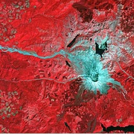
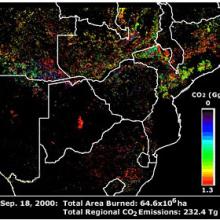
LP DAAC ingests, processes, archives, and distributes NASA data products related to land processes collected by several Earth Observing System (EOS) sensors, including ASTER, MODIS, and VIIRS; two Earth Venture Class sensors, including ECOSTRESS, and GEDI; and mission-derivate products created by select principal investigators. The LP DAAC provides data crucial to the investigation, characterization, and monitoring of biological, geological, hydrological, ecological, and related conditions and processes. In doing so, it promotes the interdisciplinary study and understanding of Earth’s integrated systems.
Several tools and services are available for searching, downloading, and ordering data from LP DAAC. Users may obtain all data products distributed by LP DAAC by using NASA’s Earthdata Search. Point and area sampling can be completed for a variety of data products from LP DAAC and other geospatial data products from other federal archives with the Application for Extracting and Exploring Analysis Ready Samples (AppEEARS). Users may also acquire data via HTTP by directly accessing LP DAAC’s Data Pool.
Contact Information
Chris Torbert, DAAC Manager
Cole Krehbiel, DAAC Scientist
Darla Werner, TSSC Task Manager
Rob Quenzer, Scientific Development
Matt Martens, Operations Manager
U.S. Geological Survey (USGS)
Earth Resources Observation and Science (EROS) Center
47914 252nd Street
Sioux Falls, SD 57198-0001
LPDAAC@usgs.gov
Website: https://lpdaac.usgs.gov/