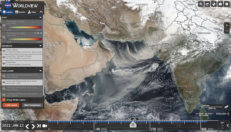
Dust storms can have an impact on human health, weather patterns as well as cause disruption through flight delays and the closure of highways. Data from NASA's Land, Atmosphere Near real-time Capability for EO (LANCE) are used to monitor and predict dust storms. This information is used by agencies within the Department of Defense to improve resource allocation in remote areas and help promote aircraft safety.
- Register for an Earthdata Login to start downloading data.
- Read the LANCE disclaimer for more information about using the data.
- Learn more: Health and Air Quality Data Pathfinder
- Aerosol Optical Depth
-
Aerosol Optical Depth (AOD) (or Aerosol Optical Thickness) indicates the level at which particles in the air (aerosols) prevent light from traveling through the atmosphere. Aerosols scatter and absorb incoming sunlight, which reduces visibility. From an observer on the ground, an AOD of less than 0.1 is “clean” - characteristic of clear blue sky, bright sun and maximum visibility. As AOD increases to 0.5, 1.0, and greater than 3.0, aerosols become so dense that sun is obscured. Sources of aerosols include pollution from factories, smoke from fires, dust from dust storms, sea salt, and volcanic ash and smog. Aerosols compromise human health when inhaled by people, particularly those with asthma or other respiratory illnesses. Aerosols also have an effect on the weather and climate by cooling or warming the earth, helping or preventing clouds from forming. Since aerosols are difficult to identify when they occur over different types of land surfaces and ocean surfaces, Worldview provides several different types of imagery layers to assist in the identification.
Product: Instrument (Platform) and Download Link Description Browse imagery in Worldview MODIS (Terra)
MOD04_L2
MODIS (Aqua)
MYD04_L2Moderate Resolution Imaging Spectroradiometer (MODIS (Terra)) L2 Aerosol, 5-Min Swath 10km
doi:10.5067/MODIS/MOD04_L2.NRT.061
MODIS (Aqua) L2 Aerosol, 5-Min Swath 10km
doi:10.5067/MODIS/MYD04_L2.NRT.061MODIS (Terra/Aqua)
MCDAODHDMODIS (Aqua)
MYDAODHDMODIS (Terra)
MODAODHDL3 Value-added Aerosol Optical Depth
MODIS (combined)
doi:10.5067/MODIS/MCDAODHD.NRT.061MODIS (Aqua)
doi:10.5067/MODIS/MYDAODHD_NRT.061
MODIS (Terra)
MODIS (Terra/Aqua) MCD19A2N L2G Multi-Angle Implementation of Atmospheric Correction (MAIAC) Land Aerosol Optical Depth
MODIS/Terra+Aqua Land Aerosol Optical Depth Daily L2G Global 1km SIN GridVIIRS (Suomi NPP) AERDB_L2_VIIRS_SNPP_NRT VIIRS/Suomi NPP Deep Blue Aerosol L2 6-Min Swath 6 km
- Corrected Reflectance Imagery
-
MODIS and VIIRS Corrected Reflectance imagery are available only as near real-time imagery. The imagery can be visualized in Worldview and Global Imagery Browse Services (GIBS).
Information on MODIS Corrected Reflectance Imagery layers including:
- Corrected Reflectance True Color (Bands 1-4-3),
- Corrected Reflectance (Bands 3-6-7)
- Corrected Reflectance (Bands 7-2-1)
Information on VIIRS Corrected Reflectance Imagery layers including:
- Corrected Reflectance True Color (Bands I1-M4-M3),
- Corrected Reflectance (Bands M3-I3-M11)
- Corrected Reflectance (Bands M11-I2-I1)
Browse Corrected Reflectance imagery in Worldview
For more on the difference between Corrected Reflectance and Surface Reflectance Imagery
- Dust
-
Product: Instrument (Platform) and Download Link Description Browse imagery in Worldview AIRS (Aqua)
AIRIBQAP_NRT.005The AIRS Dust Score science parameter is a parameter of the AIRS Level 1B Infrared quality assurance subset (AIRIBQAP_NRT). The AIRS Dust Score (Ocean, Day | Night) layer indicates the level of atmospheric aerosols in the Earth’s atmosphere over the ocean. The numerical scale is a qualitative representation of the presence of dust in the atmosphere, an indication of where large dust storms may form and the areas that may be affected. Pixels where the dust score is less than 360 are not shown in Worldview/GIBS. The imagery resolution is 2 km, sensor resolution is 45 km and the temporal resolution is daily. L1B IR quality assurance subset - Land Surface Reflectance
-
In comparison with the MODIS Corrected Reflectance product, the MODIS Land Atmospherically Corrected Surface Reflectance product (MOD09) is a more complete atmospheric correction algorithm that includes aerosol correction, and is designed to derive land surface properties.
Product: Instrument, Platform and Download Link
Description
Browse imagery in Worldview
MODIS (Aqua) MYD09
MODIS (Terra) MOD09doi:10.5067/MODIS/MYD09.NRT.061 (Aqua) and doi:10.5067/MODIS/MOD09.NRT.061 (Terra)
More information on MODIS Land Surface Reflectance Products including:
- MODIS (Aqua/Terra) Land Surface Reflectance True Color (Bands 1-4-3)
- MODIS (Aqua/Terra) Land Surface Reflectance True Color (Bands 7-2-1)
- MODIS (Aqua/Terra) Land Surface Reflectance True Color (Bands 1-2-1)
VIIRS (Suomi NPP)
VNP09_NRTVIIRS Land Surface Reflectance
The VIIRS Surface Reflectance provides continuity with the EOS-MODIS Land Surface Reflectance product.The Suomi NPP/VIIRS surface reflectance products are estimates of surface reflectance in each of the VIIRS reflective bands I1-I3, M1-M5, M7, M8, M10, and M11. Surface reflectance for each moderate-resolution (750m) or imagery-resolution (375m) pixel is retrieved separately for the Level-2 products and is obtained by adjusting top-of-atmosphere reflectance to compensate for atmospheric effects. Corrections are made for the effects of molecular gases, including ozone and water vapor, and for the effects of atmospheric aerosols. The inputs to the surface reflectance algorithm include top-of-atmosphere reflectance for the VIIRS visible bands (VNP02MOD, VNP02IMG), the VIIRS cloud mask and aerosol product (NPP-CMIP_L2), aerosol optical thickness (NPP_VAOTIP_L2, NPP_VAMIP_L2), and atmospheric data obtained from a reanalysis (surface pressure, atmospheric precipitable water, and ozone concentration). All surface reflectance products are produced for daytime conditions only.Coming soon
Visualize NRT data related to Dust Storms in Worldview
The image above shows how on January 22, 2022, a substantial dust storm enveloped the Arabian Sea. Plumes of desert dust affected populated areas around the basin, as winds carried the particles over Karachi, Mumbai, and numerous other cities and degraded air quality. Read more in the article from NASA's Earth Observatory “Dust Storm Envelops the Arabian Sea”.
