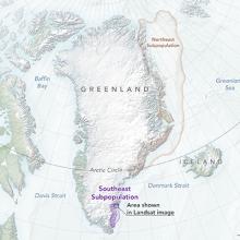
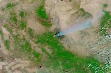
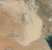
The Moderate Resolution Imaging Spectroradiometer (MODIS) continually collects data in 36 spectral channels with global coverage every 1 to 2 days. Its exceptionally broad spectral range enables MODIS data to be used in studies across numerous disciplines, including vegetative health, changes in land cover and land use, oceans and ocean biology, sea surface temperature, and cloud analysis. It also is used extensively for monitoring fires and natural hazards along with oil spills. An important attribute of MODIS data is the availability of MODIS data products in real-time and near real-time. Direct broadcast stations around the world download raw MODIS data in real-time directly from the satellite, while NASA’s Land, Atmosphere Near Real-time Capability for EOS (LANCE) provides several MODIS products within three hours of satellite observation.