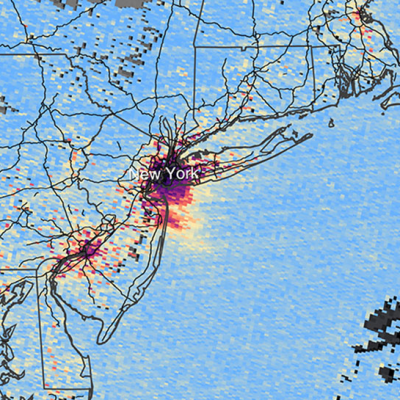
Averaged over an entire year, approximately 342 watts of solar energy fall upon every square meter of Earth. This solar power drives the weather, ocean currents, hydrologic cycle, and nearly everything else that makes our home habitable. NASA Earth observation satellites are constantly acquiring data related to incoming solar radiation, atmospheric processes, and other factors impacting energy flows into and away from the planet.
A NASA Applied Sciences project uses Earth science data acquired from satellite-borne sensors and derived from global atmospheric models to provide a better understanding of these energy resources. The Prediction Of Worldwide Energy Resources (POWER) Project improves the accessibility and use of Earth observations to support community research and applications in three focus areas: renewable energy, sustainable buildings, and agroclimatology.
Through the POWER dashboard, users can interactively work with Earth science data related to:
- Energy fluxes, including solar irradiance and thermal infrared energy from the Clouds and the Earth’s Radiant Energy System (CERES) project and the Global Energy and Water Exchanges (GEWEX) Surface Radiation Budget project
- Meteorology, particularly surface conditions with some column averaged properties such as water vapor acquired from model data available through NASA’s Goddard Earth Observing System (GEOS) and Modern-Era Retrospective analysis for Research and Applications, Version 2 (MERRA-2)
- Precipitation data available through GEOS and from NASA’s Integrated Multi-Satellite Retrievals for the Global Precipitation Measurement (GPM) Mission (IMERG)
- Derived products specific to the three POWER focus areas
Many of these data are available through NASA’s Earth Observing System Data and Information System (EOSDIS) and are distributed through NASA’s Atmospheric Science Data Center (ASDC) and Goddard Earth Sciences Data and Information Services Center (GES DISC). In addition, near real-time data also are available.
What is POWER?
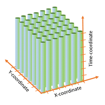
POWER provides data with global coverage and long-time series, including a full suite of low-latency, high-quality, and community-relevant variables with a large variety of openly available accessibility options. The POWER Project was initiated in 2003 as an outgrowth of NASA’s Surface meteorology and Solar Energy (SSE) project. POWER encompassed the SSE components and added new datasets with an added focus of architecture (sustainable buildings) and agriculture (agroclimatology).

Today, POWER provides parameters at daily, monthly, annual, and user-defined time periods spanning from 1981 (meteorology data) or 1984 (solar data) to within a week of real-time. Additionally, POWER provides user-defined analytic capabilities, including custom climatologies with reports featuring parameter anomalies and statistical information. Climate design condition statistics and building climate zones derived from ASHRAE (formerly the American Society of Heating, Refrigerating, and Air-Conditioning Engineers) definitions also are available.
Learning resources, documentation, and application developer pages to help new and experienced users are provided through POWER Docs. POWER also has an Esri ArcGIS Online StoryMap that walks users through the history of the project, provides an overview of tools and services, and highlights POWER user stories. Jupyter Notebooks are available to help users with POWER’s application programming interfaces (APIs).
POWER Under the Hood
POWER provides analysis-ready data (ARD) to support decision tools, modeling, and forecasting packages. Before making the ARD publicly available, the POWER science team independently validates the source shortwave solar flux, longwave flux, and meteorological datasets. Details of validation results are available on the POWER website.
POWER provides data through three basic services:
- The POWER Data Access Viewer (DAV)
- POWER APIs
- Geospatial services
The enhanced POWER DAV (currently in Beta release) is the primary interface for working with data available through the system. The viewer is a responsive web mapping application that provides easy-to-use visualization tools, data subsetting, charting, and integrated climate reports. The interface also features the ability to download NASA Earth observation and global model datasets.
The DAV provides the ability to quickly accomplish common workflows, such as:
- Using the building climate thermal zones tool (which is based on ASHRAE standards) to help inform sustainable building initiatives
- Creating quick plots of data parameter anomalies that can be used for initial site assessments
- Determining monthly average data values based on parameters of interest (e.g., temperature, humidity, wind speed) for a specific time range, visualized in an interactive map and in a dynamic chart
- Specifying data value ranges using a pixel filter with results being automatically visualized on the map

POWER’s APIs deliver ARD for inputs to decision support tools and to modeling and forecasting packages. The APIs enable direct integration into external applications; users can submit a request and a response will be returned without leaving the application in which they are working. Data are provided in formats including ASCII, ICASA, CSV, GeoJSON, NetCDF, and more.
POWER’s geospatial services allow users to visualize and explore POWER data. POWER provides several Esri ArcGIS image and feature services that also are available via NASA’s ArcGIS Online platform. These services leverage a powerful server backend to perform required processing on-the-fly along with dynamic mosaicking of images.
POWER provides image services for annual and monthly surface radiative and meteorological related parameters. The POWER team soon will release image services of these parameters along with key value-added quantities such as National Renewable Energy Laboratory (NREL) wind power classes, battery sizing for grid independent facilities, and solar geometry information.
POWER data also are in the cloud. The POWER data store, which has a volume of approximately 8.5 terabytes, is cloud-optimized and directly accessible in the NASA Goddard Mission Cloud Platform (MCP) through an Amazon Web Services (AWS)/NASA memorandum of understanding. POWER features currently in the cloud include:
- Near real-time data availability: As soon as data become available from POWER’s source providers, the data are processed and made available through an Amazon Simple Storage Service (Amazon S3) bucket
- Standardized and clean data products: Direct access to POWER’s Zarr-based analysis-ready, cloud-optimized (ARCO) products that have been standardized and configured to support long-temporal and cross variable analysis is available; these data can be used to support machine learning applications
- Enhanced discoverability: POWER’s product catalog is available through the AWS Open Data Portal as part of the Amazon Sustainability Data Initiative (ASDI)
What’s New in POWER
The latest POWER version includes hourly-based source ARD in addition to enhanced daily, monthly, annual, and climatology ARD. The daily time-series spans more than 40 years for meteorology data dating back to 1981 and includes solar-based parameters dating from 1984 onward. The hourly source data are from the CERES project and NASA’s GMAO, and span 20 years from 2001. The hourly data provide users the ARD needed to model the energy performance of building systems and provide information for working with decision support tools such as EnergyPlus Weather (EPW) files.
POWER continues to improve, develop, and expand existing and new data processing and web services to address user needs. The POWER team is working on an updated validation tool called the Parameter Uncertainty Viewer (PRUVE) that will feature user-based analytics and toolboxes for on-cloud analysis. POWER also is working on higher-spatial resolution solar and meteorological data for the continental U.S. that will support the building community in its decarbonization efforts to achieve net-zero goals.
Finally, the POWER team is collaborating with NASA’s Earth Science Data Systems (ESDS) Program to develop a new Renewable Energy Data Pathfinder. The Pathfinder will provide links to NASA data, tools, and resources (along with links to external resources) designed to help data users of all abilities explore data related to energy and Earth processes. This is scheduled for release later in 2023.
Learn More
- Earthdata Webinar: Getting to Know the NASA Prediction Of Worldwide Energy Resources (POWER) Project
- Questions or feedback? Contact the POWER team