NASA’s Level-1 and Atmosphere Archive and Distribution System Distributed Active Archive Center (LAADS DAAC) released the Geostationary Earth Orbit (GEO) – Low-Earth Orbit (LEO) Deep Blue Aerosol (DBA) product suite consisting of GEO DBA, LEO DBA, and GEO-LEO merged DBA retrievals made between May 1, 2019, through April 30, 2020. Deep Blue Aerosols define retrievals over bright surfaces such as ocean glint, deserts, or snow and ice.
GEO–LEO Deep Blue Aerosol Product Suite Now Available
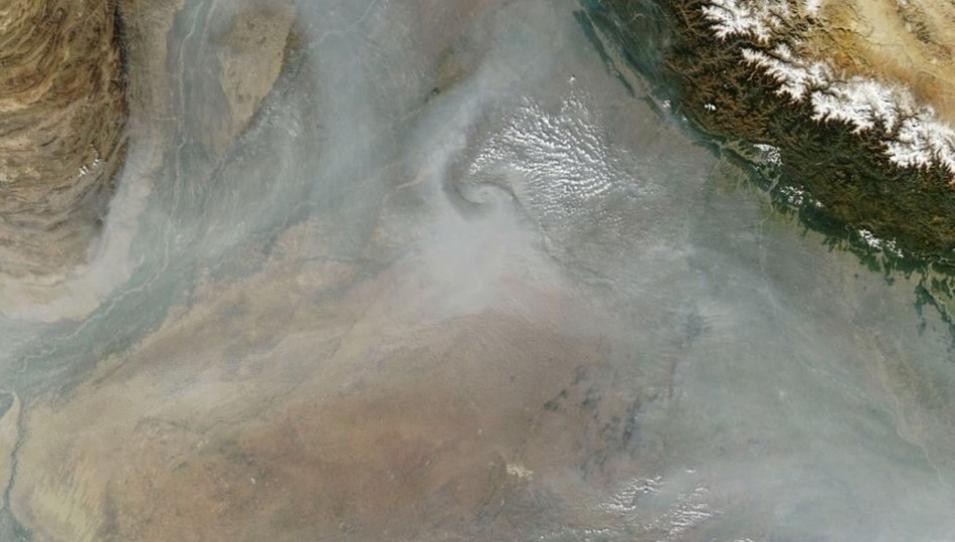
The Moderate Resolution Imaging Spectroradiometer (MODIS) on NASA’s Aqua platform captured this image of haze blanketing the region on November 20, 2023. Ground-based air quality monitors, managed by India's Central Pollution Control Board, the Delhi Pollution Control Committee, the U.S. State Department, and Nepal’s Department of Environment, reported unhealthy to hazardous levels of airborne particulate matter that day. Credit: NASA Earth Observatory
These nine GEO DBA and three GEO-LEO merged DBA products (listed in the table below) are created using versions of the Deep Blue Aerosol and the Satellite Ocean Aerosol Retrieval algorithms applied to geostationary meteorological and LEO sensors.
| Type | Platform | Instrument | Temporal Cadence | Spatial Resolution | Product |
|---|---|---|---|---|---|
| GEO | GOES-16 | ABI | 30 min. | 10 km | AERDB_L2_ABI_G16 |
| GEO | GOES-17 | ABI | 30 min. | 10 km | AERDB_L2_ABI_G17 |
| GEO | Himawari-8 | AHI | 30 min. | 10 km | AERDB_L2_AHI_H08 |
| GEO | GOES-16 | ABI | Daily | 1˚ x 1˚ | AERDB_D3_ABI_G16 |
| GEO | GOES-17 | ABI | Daily | 1˚ x 1˚ | AERDB_D3_ABI_G17 |
| GEO | Himawari-8 | AHI | Daily | 1˚ x 1˚ | AERDB_D3_AHI_H08 |
| GEO | GOES-16 | ABI | Monthly | 1˚ x 1˚ | AERDB_M3_ABI_G16 |
| GEO | GOES-17 | ABI | Monthly | 1˚ x 1˚ | AERDB_M3_ABI_G17 |
| GEO | Himawari-8 | AHI | Monthly | 1˚ x 1˚ | AERDB_M3_AHI_H08 |
| GEO-LEO | Multiple* | ABI/AHI/VIIRS/MODIS* | 30 minutes | 0.25˚ x 0.25˚ | AERDB_L2G_GEOLEO_Merged |
| GEO-LEO | Multiple* | ABI/AHI/VIIRS/MODIS* | Daily | 1˚ x 1˚ | AERDB_D3_GEOLEO_Merged |
| GEO-LEO | Multiple* | ABI/AHI/VIIRS/MODIS* | Monthly | 1˚ x 1˚ | AERDB_M3_GEOLEO_Merged |
* includes G16-Advanced Baseline Imager (ABI), G17-ABI, H08-Advanced Himawari Imager (AHI), Suomi NPP Visible Infrared Imaging Radiometer Suite (VIIRS), NOAA20-VIIRS, Terra Moderate Resolution Imaging Spectroradiometer (MODIS), and Aqua MODIS
The Level-2 (L2) GEO DBA products provide Aerosol Optical Thickness (AOT) data every 30 minutes and also serve as inputs to generate daily and monthly products. The Level-2 Gridded (L2G) GEO-LEO Merged DBA product provides gridded AOT data every 30 minutes based on seven merged GEO-LEO AOT layers. The L2G merged DBA also help produce daily and monthly products.
This suite of Deep Blue Aerosol products can be used to characterize day-to-day changes in aerosol concentrations, thereby allowing atmospheric scientists, public health experts, and others to track the rapid changes and dynamics in smoke and dust plumes that can severely impact air quality. Further, these data may enhance understanding of the aerosol diurnal cycle and offer greater insights into the relationships between meteorological processes (e.g., cloud formation, boundary layer changes, and so on) and the human activities that impact air quality. Finally, the data assimilation and modelling community may benefit from the high temporal resolution of the merged GEO and GEO-LEO aerosol products that will allow them to better characterize the sources of dust and other air pollutants.
