We are in the process of migrating all NASA Earth science data sites into Earthdata from now until end of 2026. Not all NASA Earth science data and resources will appear here until then. Thank you for your patience as we make this transition.Read about the Web Unification Project
Description
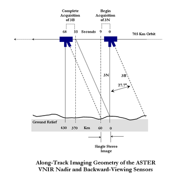
The Terra Advanced Spaceborne Thermal Emission and Reflection Radiometer (ASTER) Digital Elevation Model (AST14DEM) product is generated using bands 3N (nadir-viewing) and 3B (backward-viewing) of an ASTER Level 1A image acquired by the Visible and Near Infrared (VNIR) sensor. The VNIR subsystem includes two independent telescope assemblies that facilitate the generation of stereoscopic data. The band 3 stereo pair is acquired in the spectral range of 0.78 and 0.86 microns with a base-to-height ratio of 0.6 and an intersection angle of 27.7 degrees. There is a time lag of approximately one minute between the acquisition of the nadir and backward images. For a better understanding, refer to the diagram depicting the along-track imaging geometry diagram of the ASTER VNIR nadir and backward-viewing sensors.
Known Issues
Data acquisition gap: On November 28, 2024, one of Terra's power-transmitting shunt units failed. As a result, there was insufficient power to maintain functionality of the ASTER instrument. ASTER resumed acquisitions for the VNIR bands on January 18, 2025. Users should note the data gap in ASTER acquisitions from November 28, 2024, through January 16, 2025, for VNIR observations.
Version Description
The following improvement was implemented for the AST14DEM Version 4 data product: Data format has transitioned from legacy HDF-EOS2 to Cloud Optimized GeoTIFF (COG).
Land Processes Distributed Active Archive Center (LP DAAC)
,
Ground Data System, Japan Space Systems, National Institute of Advanced Industrial Science and Technology, Ministry of Economy, Trade, and Industry, Japan (JP/METI/AIST/JSS/GDS)
Citation is critically important for dataset documentation and discovery. This dataset is openly shared, without restriction, in accordance with the EOSDIS Data Use and Citation Guidance.
Copy Citation
Citation Copied
NASA/METI/AIST/Japan Spacesystems and U.S./Japan ASTER Science Team. (2025). ASTER Digital Elevation Model V004 [Dataset]. NASA Land Processes Distributed Active Archive Center. https://doi.org/10.5067/ASTER/AST14DEM.004 Date Accessed: 2026-07-22
NASA/METI/AIST/Japan Spacesystems and U.S./Japan ASTER Science Team. (2025). ASTER Digital Elevation Model V004 [Dataset]. NASA Land Processes Distributed Active Archive Center. https://doi.org/10.5067/ASTER/AST14DEM.004 Date Accessed: 2026-07-22
NASA/METI/AIST/Japan Spacesystems and U.S./Japan ASTER Science Team. “ASTER Digital Elevation Model V004.” NASA Land Processes Distributed Active Archive Center, 2025, https://doi.org/10.5067/ASTER/AST14DEM.004. Date Accessed: 2026-07-22
File Naming Convention
AST14DEM_00412112020183922_20250912144703.tif
The file name begins with the Product Short Name (AST14DEM), followed by the 3-digit Version Number plus the Date and Time of Acquisition designated as MMDDYYYYHHMMSS (00412112020183922), Date and Time of Processing designated as YYYYMMDDHHMMSS (20250912144703), and the Data Format (tif).
The USGS EROS User Services team is offering an hour-long webinar to share the data, tools, and services available from the Advanced Spaceborne Thermal Emission and Reflection Radiometer (ASTER) instrument aboard NASA’s Terra satellite.
Devenish, Christian, Junaid, Achmad Ridha, Andriansyah, Saryanthi, Ria, van Balen, S. (Bas), Kaprawi, Fajar, Aprianto, Ganjar Cahyo, Stanley, Richard C., Poole, Oliver, Owen, Andrew, Collar, N. J., Marsden, Stuart J.
The table below lists the variables contained within a single granule for this
dataset. Variables often contain observed or derived geophysical measurements
collected from a variety of sources, including remote sensing instruments on
satellite and airborne platforms, field campaigns, in situ measurements, and
model outputs. The terms variable, parameter, scientific data set, layer, and band
have been used across NASA’s Earth science disciplines; however, variable is the
designated nomenclature in NASA’s Common Metadata Repository (CMR).
Variable metadata attributes such as Name, Description, Units, Data Type, Fill
Value, Valid Range, and Scale Factor allow users to efficiently process and analyze
the data. The full range of attributes may not be applicable to all variables.
Additional information on variable attributes is typically available in the data,
user guide, and/or other product documentation.
For questions on a specific variable, please use the Earthdata Forum.
