Airborne Data Management Group

NASA's Airborne Data Management Group (ADMG) advances discovery of and access to Earth Science data through airborne and field investigations.

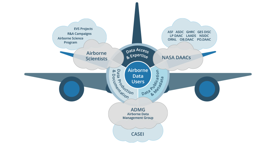
NASA’s Airborne Data Management Group (ADMG) exists to support NASA’s airborne and field science communities, NASA Earth Science data repositories, and airborne and field data users by advancing access to relevant resources, information, and data. ADMG developed and maintains NASA’s Catalog of Archived Suborbital Earth Science Investigations (CASEI). The CASEI inventory is a compilation of contextual metadata important for the discoverability and accessibility of airborne and field campaign data. Infusion of core CASEI functionality to the broader ESDIS and Earthdata web presence is underway. 

ADMG operates within the Office of Data Science and Informatics (ODSI), formerly the Interagency Implementation and Advanced Concepts Team (IMPACT), at Marshall Space Flight Center and under the direction of NASA's Earth Science Data Systems (ESDS) Program.

Image

ADMG develops processes and recommended practices for data handling, documentation, metadata, stewardship, and preservation materials to support data producers and users of NASA airborne and field data.

NASA Earth Science data and metadata standards are managed by NASA's Earth Science Data and Information System (ESDIS) Project. ADMG works with ESDIS leadership and NASA data repository personnel to provide data producers with general information as well as access to and clarifications of the requirements and standards for airborne and field data production, handling, and transfer.

Additional data stewardship resources are available below. If you have any questions, please contact ADMG (admg@uah.edu).

Principal Investigators (PIs) and Campaign Data Managers

Use the following resources to help with creating an Open Science and Data Management Plan (OSDMP):

ItemDescription

Adding Data from Orbital Missions and Airborne Investigations

ESDIS requirements for data from satellite missions, Earth Venture missions, and airborne and field investigations.

Open Science and Data Management Plan (OSDMP) Template for Data Producers (PDF)

ESDIS template for drafting an OSDMP that satisfies NASA’s Earth Science Division (ESD) requirements.

Airborne Investigation Data System Requirements (PDF)

Programmatic data system requirements to be utilized in Earth Venture Suborbital (EVS) investigations.

OSDMP Template Guide for Airborne and Field Investigators (produced by ADMG to support data producers; most recent version available on request (admg@uah.edu)

Additional ADMG guide on drafting an OSDMP that satisfies NASA’s Earth Science Division (ESD) requirements for airborne and field investigations.

ESDIS Preservation Requirements (PDF)

Content requirements for data, metadata, and supporting documentation for NASA-funded projects to ensure their proper preservation.


Data Producers

Individuals required to create a data product are encouraged to review the following resources:

ItemDescription

Data Producer’s Development Guide (DPDG) V 2.0

Guidance for developing data products that align with NASA ESD requirements.

Earthdata Pub

Guidance for navigating the data product publication process at a NASA DAAC.

Level of Service Model for NASA Earth Science Data

Information about assigning the appropriate Level of Service to data products.

ESDIS Standards Processes

Additional resources for ESDIS data standards and requirements development.

ESDIS Standards Coordination Office (ESCO) Data and Metadata Standards

Lists of ESD-approved standards and practices.


Data Delivery and Publication Process for Airborne and Field Investigations

NASA airborne and field investigations are an important part of regional and scientifically-focused studies. The methods by which airborne and field data are observed, prepared, delivered, archived, and distributed vary from the methods used for satellite data. Most significantly, in airborne and field campaigns, individual instrument scientists are responsible for:

  • Collecting data
  • Structuring data products
  • Checking data quality
  • Transferring data to the ESDIS data repository (when relevant)
  • Communicating with ESDIS repository personnel for data product transfer, review, and user guide development (when applicable)

Overall, investigation scientists bear responsibility for data product design, metadata assignment, and data formatting in line with ESDS data policies. The Data Producer’s Development Guide (DPDG) contains helpful information and considerations for data product design.

During campaigns, a field archive is used and maintained by the campaign data manager to collect and organize data and provide open access to all project science team investigators and collaborators. Within the required six-month time period from data collection, all datasets must be transferred from the field archive to the assigned ESDIS data repository (eg: NASA DAAC)  for publication. ESDIS repository personnel are responsible for the following activities: 

  • Checking incoming data
  • Ensuring data are properly documented with metadata
  • Obtaining data product Digital Object Identifiers (DOIs)
  • Distributing and archiving data via the NASA cloud environment
  • Providing simple user support (detailed questions are passed along to data producers)
  • Performing outreach activities to notify data users of data availability

In some cases, data may be passed directly from the data producer to ESDIS without going to a field archive first. The diagram below outlines the movement of data through these various steps. 


CASEI

ADMG developed, continually updates, and maintains NASA’s Catalog of Archived Suborbital Earth science Investigations (CASEI). This comprehensive inventory provides detailed contextual metadata about NASA airborne and field campaigns, as well as relevant platforms, instruments, deployments, flight details, significant events, and data product relationships. CASEI allows data users to easily access, search, and browse information associated with airborne campaigns. CASEI’s unique functionality is actively being transitioned into the broader Earthdata ecosystem to provide more seamless user support and more efficient infrastructure across ESDIS.
Image

ADMG works with NASA’s ESDIS data repositories to promote effective communication and efficient airborne and field data stewardship. Various policies and procedures exist to help bring consistency and user satisfaction to their support of the heterogeneous data collected over the past half century and into the future.

ESDIS Standards and Policies 

NASA's data and metadata standards are managed by ESDIS. Since many standards and policies were developed with a NASA satellite perspective, ADMG works to augment existing documents and/or develop new standards and/or guidance for improving airborne and field data management at ESDIS. The latest information can be found on the Airborne and Field Working Group Earthdata wiki (limited access; Earthdata login required).  

Several  data stewardship resources that ESDIS personnel may find useful are listed below. If you have questions or feel additional resources would be helpful, please contact ADMG (admg@uah.edu).


ESDIS Resources

ItemDescription

ADMG Stewardship Best Practices for Documenting and Representing NASA Airborne and Field Campaign Data and Information (PDF)

Recommended high-level practices for DAAC airborne and field data stewardship. The document outlines the methodology of development and the recommendations.

Airborne Investigation Data System Requirements (PDF)

Programmatic data system requirements to be utilized in large NASA funded investigations.

OSDMP Template Guide for Airborne and Field Investigators (produced by ADMG to support data producers; most recent version available on request to admg@uah.edu)

Additional ADMG guide on drafting an OSDMP that satisfies NASA’s Earth Science Division (ESD) requirements for airborne and field investigations.

EOSDIS Preservation Requirements (updated to include airborne and field) 

Content requirements for data, metadata, and supporting documentation for NASA-funded projects to ensure their proper preservation.

Level of Service Model for NASA Earth Science Data

Information about assigning the appropriate Level of Service to data products.

ADMG Airborne and Field Data Inventory Definitions

Terms developed by ADMG to bring consistency to language commonly used across NASA’s ESD. ESCO reviewed.

ADMG Decision Trees (PDF)

Decision trees developed by ADMG to use in building CASEI.

Airborne Science Program (ASP)

Aircraft, instrument, and campaign information.

Airborne Science Program Mission List

Airborne campaigns flown by ASP, as well as campaign descriptions and logos.

Airborne Science Newsletters and Annual Reports

Past and current aircraft, flight, and campaign information.

Over several decades, NASA’s airborne and field observations have supported instrument development, satellite sensor validation, and Earth science research across many domains. Analog data from these historical field campaigns are often discarded and underutilized beyond the original science teams due to how difficult the data are to locate and use in the modern era. In some cases, the data or data archive locations are scheduled to be eliminated, leading to complete loss of valuable data.

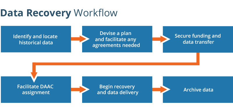
To help preserve these datasets, ADMG has facilitated data recovery efforts to support discovery, access, and reuse. ADMG tasks involve locating the data, devising data transfer plans, assisting with funding pathway exploration, and facilitating ESDIS data repository assignments for archiving data. These efforts will allow more users to access these valuable historical datasets, and support the Agency’s open science initiatives.

If you are aware of historical, analog NASA airborne and field data and need assistance with data recovery, please contact ADMG at admg@uah.edu. When new data accession into the NASA archives is paused, ADMG ensures all relevant details are documented for when accession is reinitiated to properly preserve historical, agency-funded observations.

Image
Image Caption

Typical workflow for historical analog data recovery process.

Example ADMG Data Recovery Efforts

ER-12 High-Resolution Air Photos

What: High resolution photos taken from nadir during the 1970s to 2000.

Value: Photos could be used for land cover change and ecological studies.

Effort: More than 6,000 photos that require special equipment for digitization; process to take several years.

Outcome: Data delivered directly to NASA with DAAC support for archival and public access.

P-3 Campaign History

What: Paper records at NASA's Wallop's Flight Facility (WFF) providing detailed information about NASA P-3 aircraft’s campaign history from 1991 to 2007.

Value: P-3 flight information prior to 2007 is not digitized and is difficult to locate. Capturing instrument placement by campaign supports appropriate data reuse.

Effort: Recorded information about each campaign that used the P-3; scanned flight plan documents for digitization while onsite at WFF.

Outcome: Detailed history provided to NASA's Airborne Science Program to bolster their digital records and metadata added to CASEI to improve public access to this information.

GTE DC-8 Videos

What: Nadir, side, and forward-view video cameras captured environment and ground conditions from aboard the NASA DC-8 during the Global Tropospheric Experiment program (mid 1980s - early 2000s).

Value: Videos useful for contextualizing and interpreting instrument data.

Effort: Approximately 900 VHS tapes with hours of footage that needed to be digitized.

Outcome: Analog materials to be delivered to a DAAC for digitization, uploaded to the NASA cloud environment, and made accessible with a video viewer.