Global navigation satellites provide crucial information for pinpointing precise locations on Earth. Now, a NASA-funded project is pointing researchers and businesses to important atmospheric data provided by such satellites.
GNSS Radio Occultation Data in the AWS [Amazon Web Services] Cloud is a project to create the first free and open archive of atmospheric measurements derived from Global Navigation Satellite System (GNSS) signals using a technique called radio occultation. The project’s principal investigator (PI) is Dr. Stephen Leroy, a climate researcher and a co-developer of the GNSS radio occultation (RO) remote sensing technique.
“Radio occultation is a way of measuring temperature, pressure, and other constituents in the atmosphere using radio signals from navigation satellites,” said Leroy. “The technique allows you to get vertical resolution of the atmosphere on the order of 100 meters, which is something that’s really incredible from space.”
The project is funded by the Advancing Collaborative Connections for Earth System Science (ACCESS 2019), which is a Competitive Program overseen by NASA’s Earth Science Data Systems (ESDS) Program. ACCESS supports projects that develop and implement technologies to effectively manage, discover, and utilize NASA’s archive of Earth observations for scientific research and applications.
“This ACCESS project takes an unprecedentedly large amount of GNSS RO data from NASA missions and not only makes these data publicly available in the AWS Open Data Registry, but provides tutorial demonstrations on how these archived data can be accessed in a cloud computing environment for scientific research," said Dr. Cerese Albers, the NASA ESDS program executive. "This project also developed and implemented a live-update system to ingest new radio occultation data with documentation openly available on GitHub.”
Radio Occultation Explained
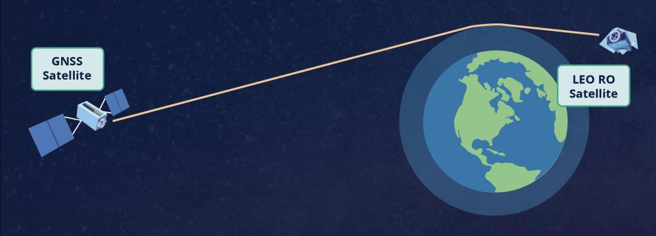
The radio occultation technique involves sending a radio signal from one navigation satellite to another through Earth’s atmosphere. Changes in atmospheric temperature, water vapor, pressure, and other characteristics slow or bend the path of the signal, which can be detected and interpreted to provide measurements.
“It’s basically a lot of the same information we get from radiosondes sent up on individual weather balloons, but on a global scale,” said Leroy. “It’s weather ballooning from space, which means when you factor in the dozens of navigation satellites in orbit, the data collected could be the equivalent of up to 30,000 balloon soundings across the entire planet a day.”
Radio occultation can be used to profile the atmosphere from the stratopause (about 50 kilometers high) to within tens of meters of Earth’s surface. The technique is particularly good at profiling the atmosphere’s middle regions, a key area of investigation for studying climate. The data are also ideal for severe weather forecasting and understanding aspects of atmospheric composition.
One Format and Place for All
The radio occultation data Leroy works with come from various orbiting GNSS spacecraft. The U.S. government controls the system known as the Global Positioning System (GPS); similar systems are deployed by China (BeiDou), the European Union (Galileo), the Russian Federation (GLONASS), India (IRNSS/NavIC), and Japan (QZSS). Before Leroy created the archive, data from these systems were stored and exclusively distributed individually by the University Corporation for Atmospheric Research (UCAR) in Colorado, NASA’s Jet Propulsion Laboratory (JPL) in Southern California, the Radio Occultation Meteorology Satellite Application Facility (ROM SAF) in Denmark, and the University of Graz in Austria.
“A major problem with the way the GNSS RO data are available, generated, and promulgated to the public is that they come from individual centers, and everyone has their own data formats. Many centers don’t even have homogeneous GNSS RO data formats,” said Leroy. “There is no data metadata or cataloging for archiving and searching, there are no uniform identifiers for comparing single radio occultation events, and so on. Basically, it would take several months of labor just to match up occultation soundings from different sources.”
To address these GNSS RO issues, Leroy assembled a working group of international experts from the key radio occultation centers and the broader field to help him create a structured, standardized, and open archive system. Their work led to the creation of the Earth Radio Occultation archive on the AWS Registry of Open Data. The archive debuted in 2022 and currently holds data for more than 29 million occultations going back to the first navigation signals sent by the GPS/Met mission in 1995. The registry is updated monthly and includes software to recognize and reformat incoming data to a standard form, metadata and cataloging, a searchable database, and high-speed Python application programming interface (API) access via the cloud. And to make downloading data easy, accessing the archive requires only an internet connection; no login or AWS account is needed.
Going Private
In the year since the system came online, it has received wide approval from researchers and even drawn the attention of private industry.
“We composed this infrastructure in such a way that it was very easy to add new missions, new contributing processing centers, and so on,” said Leroy. “This means it’s a system that other organizations and companies could adapt and use.”
The first company to adopt the system is weather data provider PlanetIQ. The company is offering its own radio occultation data for sale and is implementing Leroy’s system infrastructure as the backbone of the interface and service it’s developing.
"This is a high-value open dataset for the scientific community," said Albers. "NASA and other federal agencies typically leverage commercial offerings; however, this is a case when a commercial entity is leveraging the excellent results of a NASA-funded project.”
Leroy is open to providing his system infrastructure to more businesses or organizations working with radio occultation data. To increase awareness of the system, he’s offering workshops on using radio occultation data in the cloud, such as the ACCESS Workshop 2023 event hosted by UCAR in August 2023. And in the future, Leroy hopes to bring data from additional navigation satellite centers into the archive to further map the world of radio occultation research.
