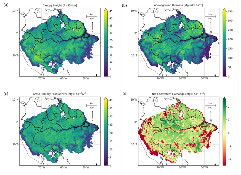
In this paper, the authors examine the productivity and carbon balance of the Amazon Rainforest by using International Space Station (ISS) Global Ecosystem Dynamics Investigation (GEDI) Level 2A (GEDI02_A) Geolocated Elevation and Height Metrics data from 2019 to 2020, and a forest model called FORMIND (forest model individual-based).
Instruments and Techniques Used
Using the GEDI data and the FORMIND model, the authors created a forest simulation to analyze forest structure, aboveground biomass, and Net Ecosystem Exchange (NEE), and estimated the age and productivity of the forest. Additionally, they created a carbon balance map of the entire forest. The authors divided the forest into several regions based on similar environmental conditions, simulating 128,000 hectares (316,294.8 acres) of forest growth.
Major Findings
The total gross primary productivity (GPP) of the forest was found to be 11.4 Pg C a-1. The productivity of the forest was found to be higher when the complexity of the canopy height was low, and vice versa, lower when there was higher complexity. The NEE, or total carbon balance of the region, was found to be −0.1 Pg C a−1. Negative NEE numbers indicate a carbon source rather than a carbon sink. Carbon sources in the forest were found to be in the western Andes, the northern Negro-Branco moist forests, and in the southeastern region where the Arc of Deforestation—an area where land is cleared for ranching, farming, and logging—is located. Overall, the authors found the Amazon Rainforest is close to carbon neutrality, meaning the forest is not actually a major carbon sink. The authors did not include carbon emissions from forest disturbances like deforestation or fires in their simulation, and they note that if they did include these factors, the Amazon Rainforest would now be considered a carbon source. They also believe the GEDI dataset was well suited for their study to examine both the vertical and horizontal structure of the forest. The high spatial maps created by the authors, along with knowledge of the forest, can help policymakers make localized decisions for reforestation to mitigate climate change.
References
Publication Reference
Bauer, L., Knapp, N., and Fischer, R., 2021, Mapping Amazon Forest productivity by fusing GEDI lidar waveforms with an individual-based forest model: Remote Sensing, v. 13, no. 22, article 4540. doi:10.3390/rs13224540
Image Reference
Image and caption provided by the authors, Bauer and others (2021).


