In spring 2016, NASA DEVELOP teams used NASA Earth observation data distributed by the Land Processes Distributed Active Archive Center (LP DAAC) in several of their projects. These data included Moderate Resolution Imaging Spectroradiometer (MODIS) and Advanced Spaceborne Thermal Emission and Reflection Radiometer (ASTER). MODIS and ASTER data were applied to water issues, including monitoring drought in Uruguay, analyzing drought in various rainforest environments, and monitoring the health of costal marsh in Alabama. These data were also used in human health related applications, including creating models to predict optimal areas for potato cultivation in Peru, predicting the risk of dengue fever in Puerto Rico, and creating community heat vulnerability maps during heatwaves in Phoenix, Arizona. Another way these data were used was in an environmental application to locate areas that can provide protection for Mule Deer in the Western US.

For more information about all of the Spring 2016 DEVELOP projects, please visit the DEVELOP archive.

Featured Project: Palm Oil Production in Indonesia

One of the projects, Calamity in Kalimantan: Palm Oil Growth at the Expense of Diversity, studied palm oil production in Indonesia. Indonesia is the world’s leading producer of palm oil; however, this has led to the palm oil industry being the biggest contributor of deforestation in the country.
Image
Image Caption

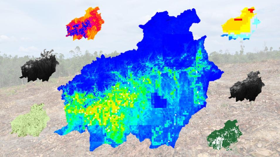
The image above demonstrates several maps created by the DEVELOP Indonesia Agriculture team using LP DAAC MODIS data and other data sources. The center map is the Maxent model output map of palm oil expansion in Central Kalimantan, Indonesia. The smaller maps indicate inputs, clockwise from bottom left to right is a map of MODIS NDVI, slope, accessibility, precipitation, elevation, and conservation areas. Credit: Indonesia Agriculture DEVELOP Team.

Instruments and Techniques Used

The Indonesia Agriculture DEVELOP team incorporated MODIS Land Surface Temperature (LST) (MOD11A1), Normalized Difference Vegetation Index (NDVI) and Enhanced Vegetation Index (EVI) (MOD13A1) and several other data sources to identify the probability of palm oil production locations in Indonesia. They then used the data to create risk maps of areas in Central Kalimantan, Indonesia, shown in the image on the right, that are at the highest risk for deforestation due to expansion of the palm oil industry. 

Major Findings

Using these maps, they were able to identify suitable locations for future palm oil expansion that would still protect the rainforests in the area. Results from this study can be used by the World Wildlife Fund (WWF) and its partners to mitigate the impact the palm oil industry has on natural resources in the area.

About the NASA DEVELOP National Program

The DEVELOP National Program is part of NASA’s Applied Sciences Program. Participants from around the country join the DEVELOP program for 10-week terms to apply data acquired by NASA Earth-observing satellites to bridge the gap between science and society. DEVELOP participants work with local, state, and federal partners to create maps and other products in nine focus areas including Agriculture, Climate, Disasters, Ecological Forecasting, Energy, Health and Air Quality, Oceans, Water Resources, and Weather. Frequently, these projects utilize data that is distributed by NASA’s LP DAAC, such as data from the MODIS instrument, which is aboard the NASA Terra and Aqua satellites, and ASTER, onboard Terra. These data are used to map a variety of environmental changes across the globe.

Any use of trade, firm, or product names is for descriptive purposes only and does not imply endorsement by the U.S. Government.

Publication Reference

Peterson, K., Riedman, M., and Childs, A., Calamity in Kalimantan: Palm Oil Growth at the Expense of Diversity, accessed May 19, 2016.

Details

Last Updated

June 13, 2025

Published

June 29, 2016

Data Center/Project

Land Processes DAAC (LP DAAC)