Introduction

The United States Geological Survey (USGS) measures river flow and flooding across the United States—an essential service for protecting lives and property, as well as water management for household, farming, industrial, and recreational use. 

Traditionally, USGS tracks rivers through a series of in-situ river monitoring stations across the nation to inform flood projections and water management decisions. These stations require USGS personnel to periodically visit for routine maintenance and calibration. 

However, for remote, or otherwise challenging-to-access regions, in-situ monitoring can be dangerous, time-consuming, and expensive. Rapid river currents, extreme temperatures, wildlife encounters, heavy equipment loads, and isolated areas can all contribute to complex situations. In Alaska’s dynamic and water-rich environment, for example, traditional methods can cost up to $40,000/year per station, with necessary individual field visits costing up to $6,000. Because of this, many rivers inevitably go unmonitored. 
Image
Image Caption

 USGS personnel must ferry traditional flow measuring equipment in remote locations such as across the Ikalukrok Creek in Alaska. Image credit: USGS

In the 2018 Satellite Needs Working Group (SNWG) survey, a biennial survey to understand the unmet Earth observation needs of civilian federal agencies, USGS requested a data product to identify water on the land surface to support this critical river monitoring need. After conducting the survey assessment, NASA proposed this solution to address these and other needs.

Science Objective: Collaboratively Design a Surface Water Data Solution to Meet the Needs of USGS 

The Observational Products for End-Users from Remote Sensing Analysis (OPERA) Project at NASA’s Jet Propulsion Laboratory (JPL) was selected by SNWG to develop the Dynamic Surface Water Extent (DSWx) data product suite. OPERA ensures its products meet the needs of requesting federal agencies by closely collaborating with end-users, including USGS, throughout the co-design process - that is, work closely together to share information on requirements, provide feedback on beta versions, and test functionality to ensure accessibility, usability, and actionability. 

For USGS specifically, key priorities include reducing risk to personnel, monitoring streamflow more efficiently, and expanding coverage to data-sparse regions. In response, OPERA and USGS co-developed the DSWx-HLS product, leveraging near-global and near-daily Harmonized Landsat and Sentinel-2 (HLS) observations—another SNWG solution. 

Image
Image Caption

June 16, 2024

Image
Image Caption

June 17, 2024

Image Caption

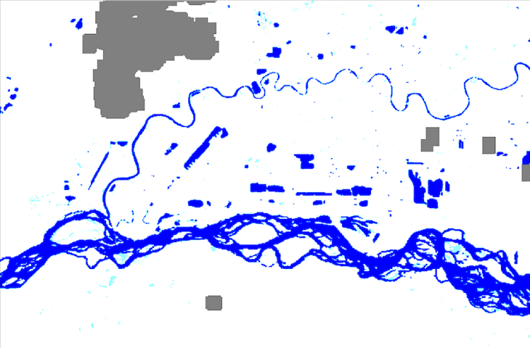
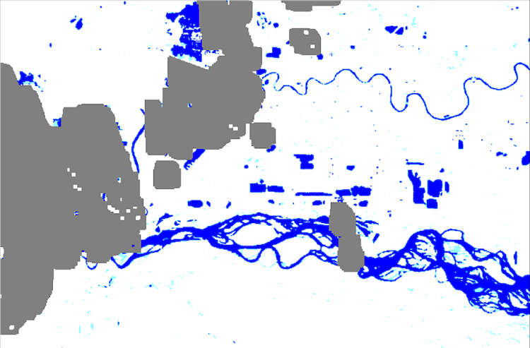
The images above show surface water extent over Fairbanks, Alaska. Cloud cover (grey areas) is a common challenge with optical remote sensing techniques when monitoring dynamic stream flow (blue). With DSWx-HLS providing near-daily observations of surface water extent, high frequency changes are readily monitored and cloud cover contamination is mitigated. Image credit: JPL/OPERA

Techniques Used by USGS

USGS is now able to use DSWx-HLS data to calculate river widths, which are then used to estimate river flow, also known as discharge. USGS relies on DSWx-HLS data for operational streamflow monitoring in Alaska, reducing hefty costs and personnel exposure to hazardous conditions, while yielding useful information they would not have otherwise.

Major Findings: Safely Monitoring Stream Flow Remotely

Adding DSWx-HLS data to the suite of tools USGS uses for river observations allows USGS to augment their in-situ river monitoring with satellite-based measurements, providing Americans with the flooding and water resource information they need, when they need it. While satellite-based monitoring is not a 100% replacement for traditional streamflow monitoring, it fills critical needs in data-sparse regions like Alaska. By the end of 2025, USGS aims to remotely monitor streamflow at more than 30 sites using NASA data, potentially expanding to more than 70 sites as the data and methods mature.

Referenced Datasets and Tools

DatasetsOPERA_L3_DSWX-HLS_V1
PlatformsHarmonized Landsat 8 Sentinel-2A/B/C (HLS)

Temporal Coverage

April 2023-present

Temporal Frequency

Sub-weekly

Horizontal Resolution

30 m
Geographic DomainNear-global (all land masses excluding Antarctica)
Latency~3 days

Data Format

Cloud-Optimized GeoTIFF
Thematic AreasCarbon Cycle and Ecosystems, Disaster Response, Earth Surface and Interior, Land Cover and Land Use Change, Ocean and Cryosphere, Water and Energy Cycle

Related Resources

DSWx product specifications, interactive guides and tutorials, and Jupyter notebooks are available through JPL’s OPERA DSWx Product Suite webpage

Learn more about NASA’s support to SNWG in assessing needs and implementing solutions. 

Details

Last Updated

July 8, 2025

Published

July 8, 2025