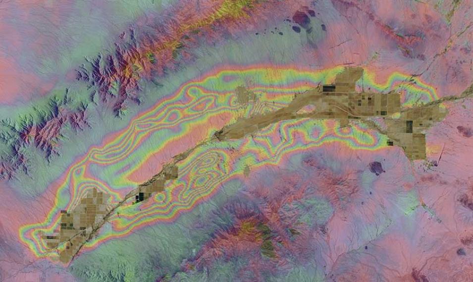
An important technology Conway uses to monitor land subsidence is synthetic aperture radar (SAR), which uses radar pulses to produce high resolution images of the Earth’s surface 24/7. By comparing images of an identical area captured days, months, or years apart, slight shifts in the land surface on the order of centimeters or millimeters can be observed. This technique, called interferometry, uses interferometric synthetic aperture radar (InSAR) images to depict these small land changes as colored fringes on an image called an interferogram. An interferogram shows the location of subsidence and allows you to estimate the magnitude of subsidence based on the number of complete fringe cycles. Conway supplements InSAR images with global navigation satellite system (GNSS) data, which provide pinpoint measurements of locations anywhere in the world. He also uses relative and absolute gravimeters to monitor aquifer storage changes. Gravimeters are instruments used to measure local gravitational fields. These gravitational fields are affected by changes in the amount of water contained in aquifers, and measurements of these gravity changes provide information about aquifer water resources. Finally, Conway uses depth-to-bedrock modeling and aquifer storage estimates to keep track of Arizona’s water resources.
Current research focus: Conway uses InSAR and GNSS data to determine the spatial extent, magnitude, and rate of historical and current land subsidence. The majority of the InSAR data that ADWR collect, process, and analyze are for areas in south-central and southern Arizona, which is at the northern edge of the Sonoran Desert. This region is home to not only Phoenix and Tucson, the two largest cities in the state, but also the location of extensive agriculture. This combination of high water demand and low annual precipitation leads to significant areas of subsidence.
Conway also monitors aquifer storage using gravimeters to acquire micro-gravity measurements, which provide data about aquifer storage and dynamics. Since 1999, he has focused this research in the Pinal and Phoenix Active Management Areas in the central and south-central areas of the state. These data, along with depth-to-groundwater data, are used by ADWR’s groundwater modelers for the calibration and validation of models describing water resources.
Data products used; all are available through the Alaska Satellite Facility Distributed Active Archive Center (ASF DAAC):
- Advanced Land Observing Satellite-1 (ALOS-1) Phased array L-band synthetic aperture radar (PALSAR), 10 to 100 meters resolution; each satellite frame is 40 to 70 kilometers; 46-day repeat [doi:10.5067/JBYK3J6HFSVF and doi:10.5067/Z97HFCNKR6VA]
- Radarsat-1, 10 to 100 meters resolution; each satellite frame is 100 kilometers; 24-day repeat
- Sentinel-1A, 20-meter resolution; each satellite frame is 250 kilometers; 12-day repeat
Research findings: A comparison of historical InSAR data with more recent data shows that land subsidence rates have decreased between 25% and 90% in groundwater active management areas where imported Colorado River water has been used to offset groundwater pumping. As a result, groundwater levels in these areas have been recovering since the mid 1990’s. In addition, areas that are either outside groundwater active management areas or that do not have access to imported Colorado River water to offset groundwater pumping are experiencing increased land subsidence rates as much as three to four times higher when compared with historical InSAR data.
Read about the research:
Conway, B.D. (2014). Arizona Department of Water Resources Land Subsidence Monitoring Report No 2. View the Land Subsidence Monitoring Report.
Conway, B.D. (2014). Monitoring Land Subsidence and Floodplains in Arizona. Alaska Satellite Facility News and Notes, 10(2). View the ASF News and Notes newsletter.
Conway, B.D. & Cook, J.P. (2013). Monitoring Evaporite Karst Activity and Land Subsidence in the Holbrook Basin, Arizona using Interferometric Synthetic Aperture Radar (InSAR). Proceedings for the 13th Multidisciplinary Conference on Sinkholes and the Engineering and Environmental Impacts of Karst. View the 2013 conference report.
For more information
Explore more Data User Profiles
