Sea Surface Salinity Datasets Now Available on the SNWG Earthdata Search Portal

Access Sea Surface Salinity with Sea Ice Mask, a NASA Satellite Needs Working Group solution, to discern salinity values close to the sea ice edge.

As part of the Satellite Needs Working Group (SNWG)’s Sea Surface Salinity (SSS) with Sea Ice Mask solution, three products were recently added to the SNWG Earthdata Search Portal:

These products help address the need for low-latency measurements of sea surface salinity near the sea-ice edge, a gap identified during the SNWG 2020 assessment. 
Image
Image Caption

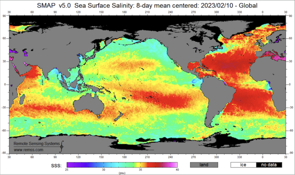
The figure shows mean SSS values in practical salinity units (psu) from the SMAP RSS SSS Version 5.0 product. Image credit: Remote Sensing Systems

For the SMAP mission’s SSS products from RSS, NASA’s Ocean Salinity Science Team (OSST) added a flag in Earthdata Search to indicate the fraction of ice versus ocean. This flag enables users to discern salinity values closer to the sea ice edge, which provides more reliable insight into ocean circulation changes and improves ocean and sea ice forecasting systems. This information can also help users more efficiently identify navigable waters for industries such as shipping, tourism, or military operations.

SNWG Solutions

Every two years, SNWG releases a survey to federal agencies to identify their satellite Earth observation needs. Through this evaluation, gaps in the current data record are highlighted, and NASA solutions are formulated and developed to address the agencies' needs. Solutions, which are implemented together with agency partners and end users, may generally include a harmonization of data from multiple satellites, the development of a new tool or service, or an enhancement of an existing data product or service to better meet agency needs.

Data products from SNWG solutions are made available through the SNWG Earthdata Search Portal. This portal refines the data available within Earthdata Search to only SNWG-relevant products while maintaining Earthdata Search features for search, discovery, and access. The portal currently contains over 70 different data products including Harmonized Landsat and Sentinel-2 (HLS) products, Observational Products for End-Users from Remote Sensing Analysis (OPERA) datasets, commercial data, water quality products, and ICESat-2 Quick Look products.

Details

Last Updated

Published