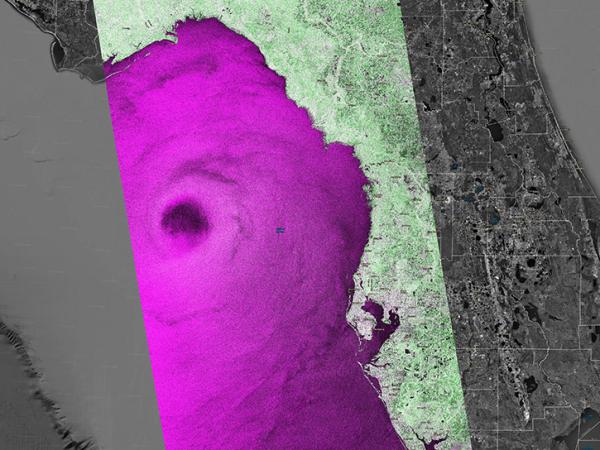
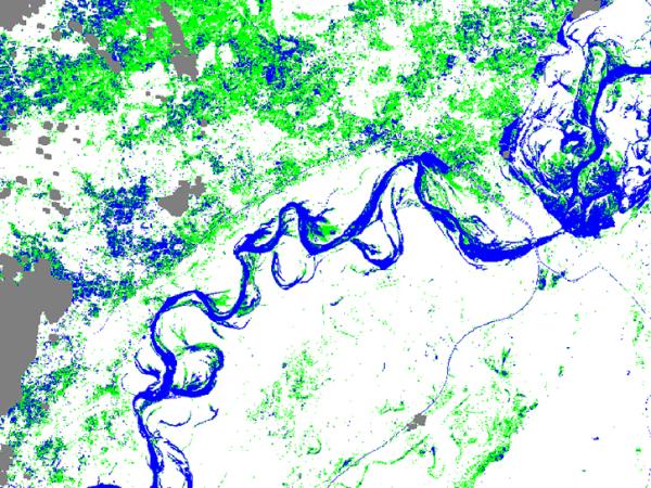
image of OPERA mapping over Earth
image of Hurricane Helene using OPERA
image of waterways using OPERA

OPERA

Observational Products for End-Users from Remote Sensing Analysis

NASA's Observational Products for End-Users from Remote Sensing Analysis (OPERA) project located at the Jet Propulsion Laboratory generates data products that help scientists understand key areas in Earth systems.

OPERA's focus areas include surface water extent, surface disturbance, surface displacement, and vertical land motion. These were selected in response to needs identified by the Satellite Needs Working Group (SNWG) in 2018 and 2020.

Learn more about OPERA's data products, workshops, and mission.

Level-3 SAR and Optical Data Products

The OPERA project offers a suite of Level-3 data products that integrate Synthetic Aperture Radar (SAR) and optical remote sensing to support environmental monitoring and scientific research.

The Dynamic Surface Water eXtent (DSWx) product suite provides near-global coverage of surface water dynamics. These products are derived from Sentinel-1 SAR data (with future support for NISAR) and harmonized Landsat-8 and Sentinel-2 optical imagery. DSWx products are distributed through NASA's Physical Oceanography Distributed Active Archive Center (PO.DAAC).

The Surface Disturbance (DIST) product suite detects changes in the Earth’s surface using both Sentinel-1 SAR and harmonized Landsat-8/9 and Sentinel-2 optical data. DIST products are available through NASA's Land Processes DAAC (LP DAAC).

The Surface Displacement (DISP) product suite focuses on North America and measures ground displacement using Interferometric SAR data from Sentinel-1 and, in future releases, NISAR. DISP products are available from NASA's Alaska Satellite Facility DAAC (ASF DAAC).

Level-2 SAR Data Products

OPERA also provides Level-2 SAR products, enabling detailed analysis of land surface characteristics and deformation.

Radiometric Terrain Corrected (RTC) SAR Backscatter Products offer near-global coverage of land surface radar backscatter data corrected for terrain effects.

RTC SAR Backscatter Static Layers provide additional supporting layers to complement the dynamic backscatter data.

Coregistered Single-Look Complex (CSLC) Products for North America enable time-series analysis of SAR phase and amplitude data, supporting applications such as surface deformation monitoring.

CSLC Static Layers provide essential metadata and supporting information for interpreting the CSLC data.

All Level-2 SAR data products are distributed by ASF DAAC

ProductDocument / fileDescriptionFormatDownload

CSLC-S1

Product Specification DocumentSpecifications of the OPERA Level-2 Coregistered Single-Look Complex (CSLC) product that uses Sentinel-1 SLC products as the primary image-based input. Accordingly, this data product is referred to by the short name CSLC-S1..pdfCSLC-S1 Product Specification document
CSLC-S1-STATICProduct Specification DocumentSpecifications of the OPERA Level-2 Radiometric Terrain-Corrected SAR Backscatter from Sentinel-1 (CSLC-S1) Static Layers (CSLC-S1-STATIC) product. It is distributed separately from the CSLC-S1 products, and it is only produced once (or a limited amount of times) for CSLC-S1 products characterized by the same burst identification string, i.e., for all the Sentinel-1 bursts covering the same geographical area on the ground. The CSLC-S1-STATIC contains both data raster layers (e.g., geocoded geometry layers) and product metadata..pdfCSLC-S1-Static Product Specification document
CSLC-S1 Product Calibration/Validation (CalVal) Database

Calibration/validation (CalVal) database for the OPERA CSLC-S1 product. The CalVal database is a zip file that contains:

  • Ancillary data products needed for validation, tables with CSLC-S1 product metadata (including links to the CSLC-S1 CalVal collections and static layers)
  • Validation reports detailing the results of the validation process
  • A CalVal database reference document that details the contents of the database

This database is designed to be read and used by the OPERA CSLC CalVal GitHub repository to reproduce the validation process and results. 

.zip

OPERA CSLC CalVal GitHub repository 

Products can be downloaded by request.

CSLC_S1 BurstsBurst Database

SQLite file generated by the OPERA ADT containing relevant information on the bursts acquired worldwide throughout the duration of the S1-A/B mission. Since the S1-A/B sensors perform systematic burst acquisitions, the burst geographical location on the ground is almost identical at each pass. Therefore, each burst can be identified by a unique alphanumeric string called a burst identification number or burst ID. The burst database includes the burst ID for all the bursts generated throughout the S1-A/B mission; each burst ID follows the same convention adopted by ESA in the generation of their burst map. The burst database includes other relevant processing information, such as the relative orbit number, the corner coordinates, and the projection system of the geographical grid, which generates each CSLC-S1 product.

Using the burst database while producing CSLC-S1 products guarantees that a time series of CSLC-S1 products characterized by the same burst ID shares the same geographical grid, i.e., they can be different pixel-wise. 

.zip

These products can be downloaded directly from an S3 bucket.

The burst database is generated by the OPERA ADT and is available from the GitHub repository. The script inputs the ESA burst map (IW mode, in SpatiaLite format). 

The ESA burst map can be downloaded.

CSLC_S1Interactive Guides
  • Visualization Guide - Illustrates how users can manipulate products in the open-source QGIS software
  • Jupyter Notebook Tutorials - Introductory guides written in a Jupyter Notebook environment that showcases select applications

.pdf 

Github


Visualization Guide

Tutorial 1: How to generate interferograms (without having to download OPERA CSLC-S1 products locally). This example is for the Ridgecrest Earthquake in California from July 2019.

CSLC-NI

DocumentationNISAR is scheduled to be launched in 2025.--

RTC-S1

Product Specification DocumentDescribes the specifications of the OPERA Level-2 Radiometric Terrain-Corrected (RTC) product that uses Sentinel-1 SLC data as the primary image-based input..pdfRTC-S1 Product Specification document 
RTC-S1 STATICProduct Specification DocumentThe describes the specifications of the OPERA Level-2 Radiometric Terrain-Corrected SAR Backscatter from Sentinel-1 (RTC-S1) Static Layers (RTC-S1-STATIC) product. The RTC-S1-STATIC product provides radar geometry layers, such as local incidence angle or incidence angle, that describe the Sentinel-1 acquisition geometry associated with the OPERA RTC-S1 products with the same burst ID..pdfRTC-S1-Static Product Specification document 
RTC-S1Product Calibration/Validation (CalVal) Database

OPERA_RTC_Calval_Database.zip: This file contains the calibration/validation (CalVal) database for the OPERA RTC-S1 product. The CalVal database is a zip file that contains:

  • Ancillary data products needed for validation
  • Tables with RTC-S1 product metadata (including links to the RTC-S1 CalVal collections and static layers)
  • Validation reports detailing the results of the validation process
  • A CalVal database reference document that details the contents of the database

This database is designed to be read and used by the OPERA RTC CalVal GitHub repository to reproduce the validation process and results. 

.zip

OPERA RTC CalVal GitHub repository

Products can be downloaded by request.

RTC-S1 BurstsBurst databaseThe SAS requires a burst database (SQLite file) for operations so that RTC-S1 products with the same bust IDs have the same map projection and geographic grid. The script inputs the ESA burst map (IWmode, in SpatiaLite format). SQLite

The burst database is generated by the OPERA ADT and is available from the GitHub repository

Products can be downloaded directly from an S3 bucket

The ESA burst map can be downloaded.

RTC-S1Interactive Guides

Jupyter Notebook Tutorials 

  1. Introductory guides written in a Jupyter Notebook environment that showcases select applications

ASF StoryMap Tutorials 

  1. Tutorial illustrating different ways to access and explore the RTC-S1 products, including workflows that allow you to interact with these cloud-optimized rasters directly in cloud storage without downloading them first
  2. Change Detection workflow for OPERA Radiometric Terrain-Corrected products from Sentinel-1 (RTC-S1)
Varies

Jupyter Notebook Tutorial 1: How to mosaic and visualize RTC-S1 images

ASF StoryMap Tutorials:

OPERA Sentinel-1 RTC -- Cloud-Optimized Access for Sentinel-1 Radiometric Terrain Corrected SAR Backscatter Products from OPERA

Change Detection using OPERA Sentinel-1 RTC

DISP-S1

Product Specification DocumentDescribes the specifications of the OPERA Level-3 Land-Surface Displacement (DISP) product from Sentinel-1 (S1). It is generated from a sequence of Level 2 CSLC products and is a high-quality InSAR-derived displacement product with reduced decorrelation noise using a hybrid Persistent Scatterer (PS) and Distributed Scatterer (DS) time series processing approach. The DISP-S1 product provides information on anthropogenic and natural changes on Earth's surface, such as subsidence, tectonics, and landslides..pdf

DISP-S1 Product Specification document 

Note: The DISP-S1 product is scheduled to be available through ASF in 2025.

DISP-NI

DocumentationNISAR is scheduled to be launched in 2025.--