User Profile: Dr. Jida Wang

Data from NASA’s PO.DAAC help scientists like Dr. Jida Wang monitor the state of surface water resources around the globe.

Dr. Jida Wang, Associate Professor, Department of Geography and Geospatial Sciences, Kansas State University

Image
Dr. Jida Wang, Associate Professor, Department of Geography and Geospatial Sciences, Kansas State University. Image courtesy of Jida Wang.

Research Interests: Hydrology and limnology; surface water abundance and dynamics in lakes, reservoirs, and wetlands; using satellite data to monitor the variability in lake water balance and quality; understanding how lakes and reservoirs function as sentinels, regulators, and integrators of climate change.

Research Highlights: Beyond changing weather patterns, melting glaciers, and rising sea levels, the warming of Earth's climate may profoundly alter Earth’s freshwater resources—lakes, rivers, and reservoirs—resulting in significant societal impact. Without an adequate means of monitoring the volume of freshwater stored in these resources and the processes that affect it, attempts to assess the full scope of environmental change on the populations and sectors of the economy that rely on them would be limited at best. 

Further, having robust data on Earth’s freshwater resources is imperative for their management as well as in planning for and responding to natural hazards like floods and droughts, particularly in areas home to large populations.

Among the researchers working to make such monitoring and datasets a reality is Dr. Jida Wang, Associate Professor in the Department of Geography and Geospatial Sciences at Kansas State University.

Wang’s work in limnology, or the study of the physical, biological, and chemical features of lakes and other bodies of freshwater, and surface hydrology focuses on three related topics: 1) improving hydrological datasets; 2) using data from multiple satellite missions to monitor lake water balance, particularly in climate-sensitive areas and water-stressed regions; and 3) integrating methodologies such as remote sensing, in-situ measurements, and hydrological modeling to seek lake change attribution and suggest socioeconomic implications.

For example, Wang is a member of the current science team for the Surface Water and Ocean Topography (SWOT) satellite mission. SWOT is a joint mission between NASA and the Centre National D'Etudes Spatiales (CNES, the French space agency), with contributions from the Canadian Space Agency (CSA) and the United Kingdom Space Agency.
Image
An artistic rendering of the Surface Water and Ocean Topography (SWOT) satellite with its a Ka-band Radar Interferometer (known as KaRIN) extended. KaRIN will measure surface water extents and water levels in lakes, reservoirs, floodplains, and potentially wetlands. Credit: NASA.

SWOT isn’t scheduled for launch until December 5, 2022, but researchers are hard at work to ensure it will provide the scientific community with high-quality data products.

“I am one of the contributors to the SWOT a priori lake dataset (PLD, based on Landsat-8 mapping), which contains the boundaries and basic processing, ephemeris, and limnologic metadata of 6 million natural lakes and human-made reservoirs greater than 1 hectare,” said Wang. “[This dataset] will enhance our vision of the physical distribution of surface water bodies and will provide multiple satellites, including SWOT, with a high-resolution a priori water mask for monitoring lake dynamics and reservoir operations.”

SWOT will provide data products on changes in lake storage and river discharge, and both data products will be based on the PLD and a separate, independently developed a priori river dataset. Wang and his colleagues, including postdoctoral researcher Dr. Safat Sikder, have been working to harmonize these datasets so they can, in Wang’s words, help “bridge lake and river sciences.”

"Lakes are often considered as water stores and lentic (hydrologically stationary) systems, but many of them are connected to each other through river networks, which are part of the drainage system,” he said. “Our work constructing global lake hydrography helps decipher where each lake is drained from and how lakes are connected to each other through rivers and non-channelized flow (i.e., lake drainage topology).”

According to Wang, although global river hydrography data are proliferating, lake hydrography datasets that include lake catchments and drainage topology are lacking.

“The current PLD emphasizes individual lake entities, but provides no metadata depicting drainage hydrography,” Wang said. “Without such information, even if we do have lake change observations through SWOT, we will be limited in our understanding of the lake changing mechanisms and the impacts of lake and reservoir storage changes on the downstream rivers.”

This hydrography information is important for the scientific application of the forthcoming lake data products from SWOT because a lake’s water mass balance and water quality attributes (e.g., turbidity, nitrates, dissolved oxygen, and temperature) are governed by the characteristics of the lake’s drainage catchment; changes in the water storage and quality of one lake affect those of another via the transfer of water, sediments, nutrients, and energy along the connected rivers.

The goal of Wang and his team is to enhance the existing SWOT PLD—to bring it from an operational to a science-quality product—by incorporating their recently released dataset that identifies human-constructed reservoirs and their on-going work to build the first-known global lake catchment and topology dataset.

Image
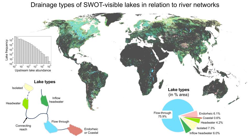
This graphic illustrates the configured drainage type of each SWOT PLD lake in relationship to the river networks. Flow-through and inflow headwater lakes account for more than 80% of the global lake surface area, highlighting the essential roles of lakes and reservoirs in regulating river systems. Graphic courtesy of Jida Wang and Safat Sikder.


“Knowing the drainage position of each lake will help us better leverage SWOT’s measurements of lake storage variability to improve and constrain river discharge estimation,” said Wang. “Also, since lakes sequester a large amount of organic and inorganic carbon, deciphering how global lakes are connected through drainage networks will also complement our carbon routing models.”

In addition to improving these a priori data, Wang is combining satellite observations from several missions along with data from other sources to monitor the water balance—the inputs and outputs of water—of lakes and reservoirs around the globe.

“As lakes and reservoirs store the largest amount of liquid freshwater on Earth’s surface, tracking their dynamics is essential to assessing the abundance of surface water resources,” he said. “Human-created reservoirs are ubiquitous across many basins today, so a more detailed temporal record for reservoir storage variability is critical to assessing human footprints on surface hydrology, generalizing reservoir operation rules, quantifying reservoir impacts on river regimes, and improving discharge estimation and water management in transboundary basins.”

Wang also uses a mix of remotely sensed data, in-situ measurements, and outputs from hydrological models to zero-in on the drivers of lake change, which are often indicative of climate change and direct human activities. For example, Wang has:

  • Applied digital elevation models (DEMs), such as NASA's Shuttle Radar Topography Mission (SRTM) DEM and TerraSAR-X add-on for Digital Elevation Measurements (TanDEM-X), and data from NASA’s Gravity Recovery and Climate Experiments (GRACE) mission to determine the dominant cause of the recent lake expansion across the Asian Water Tower, a large store of ice on the Tibetan Plateau that serves as a source of freshwater for nearly 2 billion people
  • Combined Moderate Resolution Imaging Spectroradiometer (MODIS) imagery, gauge measurements, and hydrologic model outputs to compare the impact of China’s Three Gorges Dam, the world’s largest hydroelectric project, on recent inundation area declines in the lakes of the Yangtze River Plain, with the effects of climate variability and human water consumption
  • Used GRACE satellite data to reveal a substantial water storage loss from the global endorheic basins to help determine how much of the water loss in these land-locked basins came from surface water components, such as lakes and reservoirs, and how more accurate estimations of lake storage change can help close sea level budget gaps (see the 2018 paper associated with this research)

Wang obtains his research data from several sources, including NASA’s Physical Oceanography Distributed Active Archive Center (PO.DAAC). Located at NASA's Jet Propulsion Laboratory in Southern California, PO.DAAC manages, archives, and distributes data from more than 30 satellite and instrument missions, along with tools and resources in NASA’s Earth Observing System Data and Information System (EOSDIS) collection pertaining to the physical processes and condition of the global ocean, the cryosphere, and the terrestrial hydrosphere.

For instance, in his work with the SWOT Science Team, Wang uses PO.DAAC’s preliminary SWOT data derived from instruments currently in orbit to develop and evaluate the mission’s forthcoming data products, which will use data from the SWOT PLD that Wang and his colleagues are developing.  

Wang also uses PO.DAAC data on water surface elevation, precipitation, and other topics from several current satellite missions.

“I use data from the constellation of radar and lidar altimetry sensors, such as those onboard the Jason satellites, to retrieve the time series of lake and reservoir water surface elevation,” he said. “I also use data from GRACE and the GRACE Follow-On (GRACE-FO) to quantify the impact of net precipitation on the Tibetan lake water storage gains and understand terrestrial water storage anomalies between global exorheic and endorheic systems (i.e., respectively, drainage basins whose surface waters do and do not run into the ocean) and within different climate zones.”

In 2018, Wang published a study that investigated the rapid expansion of alpine lakes in the Inner Tibetan Plateau, which is contrary to the widespread water loss reported in many endorheic basins in other parts of the world.

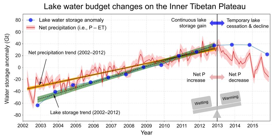
The causes of the Tibetan lake expansions have been attributed to increasing precipitation over the plateau (referred to as “wetting”) and excess meltwater supply due to net water losses in glaciers and permafrost (regional “warming”), but scientists did not always agree as to which one was the primary driver. To find out, Wang and his colleague Dr. Fangfang Yao (now a researcher at the Cooperative Institute for Research in Environmental Sciences at the University of Colorado Boulder) integrated Landsat images, SRTM and ASTER DEMs, and radar altimetry data to estimate and validate water storage changes in hundreds of Tibetan lakes since 2002 (see graphic below). The researchers found an average water storage gain of 7.3 gigatons per year in the studied lakes from 2002 to 2015. When broken down, these findings revealed a drastic monotonic water gain of 9.1 gigatons per year before 2012, a deceleration and pause during 2013–2014, and then an intriguing temporary decline after 2014.

Image
As shown in this graphic, increased net precipitation over the Tibetan Plateau from 2002–2012 resulted in rapid lake expansion. However, a decrease in net precipitation after 2013 did not trigger an immediate decline in lake storage. Instead, lake water storage started to decline in 2015. This time lag implies that warming-induced water supplies from the cryosphere, such as melting glaciers and thawing permafrost, may have temporarily compensated for the lake storage loss caused by the decrease in net precipitation, although this warming effect was unable to completely reverse the effect of net precipitation. Graphic courtesy of Jida Wang and Fangfang Yao.


To better understand the mechanism driving this change, Wang and Yao applied gravity measurements from GRACE satellites to derive a terrestrial water storage anomaly time series over the Tibetan Plateau. Because the Inner Tibetan Plateau is endorheic, meaning there is no inflow or outflow through the surface, the researchers concluded the terrestrial water storage anomalies were caused by vapor fluxes through the atmosphere. Then, using a mass balance model, they estimated that net precipitation (i.e., precipitation minus evapotranspiration) explained about 70% of the net lake storage gain from 2002 to 2012 and the entire lake storage loss after 2013, which suggests that, despite the importance of warming-induced cryospheric contributions, “wetting” was the primary driver of the alpine lake dynamics in the region.

Although the alpine lakes of the Asian Water Tower can serve as indicators of climate change, lake dynamics in densely populated fluvial plains can signal the effects of both climate and human activity on ecosystems.

As a case in point, Wang published an earlier study in 2017 that disentangled  the causes of lake-area decline in the Yangtze River Plain, East Asia’s largest freshwater lake system, and one of the world’s most populated, rapidly developing, and ecologically diverse regions.

Wang began this research by collecting thousands of daily surface reflectance images acquired from 2000 to 2011 by the MODIS instrument aboard NASA’s Terra satellite. These images revealed a widespread decline of the total lake inundation area across the Yangtze Plain, with a cumulative decrease of nearly 10% during this studied decade. Further, this decline coincided with the initial and strengthening water regulation at the Three Gorges Dam, continued growth in rates of water consumption as a result of China’s economic development, and an increase in climate anomalies throughout the Yangtze Basin.

To determine the primary cause of the decline in lake area, which required separating the effect of climate forcing from the impact of direct human activities, Wang collected MODIS imagery showing high-frequency variability in the area of the region’s lakes, Yangtze gauge measurements, and the outputs from hydrological models. When his analysis was complete, he concluded that climate impact was the predominant driver of this decadal decrease in the region’s lake area.

Image
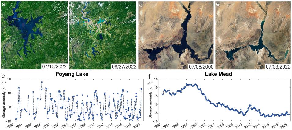
As seen in this true-color Landsat imagery, this summer’s record-breaking heat and drought led to a substantial drawdown of Lake Poyang, China’s largest freshwater lake, and Lake Mead, the largest reservoir in the United States. The time series show multidecadal water storage anomalies in these two lakes, derived from Landsat images and multi-mission altimetry (dots represent monthly means and dashed lines represent five-month filter). As shown, water storage signals for Lake Poyang were dominated by intra-annual variability whereas the signals for Lake Mead were dominated by interannual to decadal changes. Credit: Image courtesy of NASA's Earth Observatory; data courtesy of Fangfang Yao and Jida Wang.


“Roughly 80% of the observed lake decline could be attributable to concurrent climate variability,   which appeared closely related to the El Niño-Southern Oscillation,” he said. “This does not mean the Three Gorges Dam had no impact on the downstream lake system, but its main impact so far was the change in the lake seasonal or intra-annual inundation variability, not an inter-annual area decline.”

The dam’s impact on the lake system was particularly evident around early fall, when the Three Gorges Dam bore no major burden for flood control and was therefore impounding water to prepare for hydropower generation. When this occurred, a large amount of water was stored in the reservoir, reducing the Yangtze flow reaching downstream. This, in turn, drained part of the water storage in lakes connected to the river. Sedimentation in the Three Gorges Reservoir also caused channel incision along the middle and lower reaches of the Yangtze River, but thus far, these channel morphic changes had resulted in only marginal impacts on the surrounding lakes.

Wang’s results also showed that the impacts of downstream human water consumption (aggregating agricultural, industrial, and domestic sectors) were surprisingly comparable to those of the Three Gorges Dam.

“Combining the effects of the Three Gorges Dam and downstream water consumption, which were sometimes stronger at an intra-annual scale, explained about 10-20% or less of the inter-annual lake area decline,” he said.  “The remaining fraction of the lake decline might be related to other anthropogenic factors such as sand dredging from the lake bottoms and local land use land cover changes.”

Wang notes, however, that the direct impacts of human activity have been increasing. For example, although the Three Gorges Reservoir was filled to its maximum storage capacity in 2010 (meaning that the dam hasn’t reduced the annual flow of the Yangtze River since 2010), it continues to trap sediments, meaning the erosion and incision it causes in the downstream Yangtze channel will likely persist.

At the same time, remotely sensed data from NASA satellites and other sources will continue to play a crucial role in helping Wang and his colleagues develop the robust datasets and methodologies required to adequately assess the effects of climate and environmental changes on Earth’s freshwater resources for everyone’s benefit.

Representative Data Products Used or Created:

Available through PO.DAAC:

  • JPL GRACE and GRACE-FO Mascon Ocean, Ice, and Hydrology Equivalent Water Height Coastal Resolution Improvement (CRI) Filtered Release 06 Version 
    doi:10.5067/TEMSC-3JC62
  • SWOT Simulated Level 2 North America Continent High-Rate Lake Vectors Product Version 1.0 (SWOT_SIMULATED_NA_CONTINENT_L2_HR_LAKESP_V1)
    doi:10.5067/KARIN-2LSP1

Other Data Products Used:

Read about the Research:

Wang, J., Walter, B.A., Yao, F., Song, C., Ding, M., Maroof, A.S., Zhu, J., Fan, C., McAlister, J.M., Sikder, S., Sheng, Y., Allen, G.H., Crétaux, J-F., & Wada Y. (2022). GeoDAR: Georeferenced global dams and reservoirs dataset for bridging attributes and geolocations. Earth System Science Data, 14: 1869-1899. doi:10.5194/essd-14-1869-2022

Wang, J., Song, C., Reager, J.T., Yao, F., Famiglietti, J.S., Sheng, Y., MacDonald, G.M., Brun, F., Müller Schmied, H., Marston, R.A., & Wada, Y. (2018). Recent global decline in endorheic basin water storages. Nature Geoscience, 11: 926-932. doi:10.1038/s41561-018-0265-7

Yao, F., Wang, J., Yang, K., Wang, C., Walter, B., & Crétaux, J-F. (2018). Lake storage variation on the endorheic Tibetan Plateau and its attribution to climate change since the new millennium. Environmental Research Letters, 13: 064011. doi:10.1088/1748-9326/aab5d3

Wang, J., Sheng, Y., & Wada, Y. (2017). Little impact of the Three Gorges Dam on recent decadal lake decline across China’s Yangtze Plain. Water Resources Research, 53(5): 3854-3877. doi:10.1002/2016WR019817

Sheng, Y., Song, C., Wang, J., Lyons, E.A., Knox, B.R., Cox, J.S., & Gao, F. (2016). Representative lake water extent mapping at continental scales using multi-temporal Landsat-8 imagery. Remote Sensing of Environment, 185: 129-141. doi:10.1016/j.rse.2015.12.041

Explore more Data User Profiles

Last Updated