User Profile: Dr. Timothy Lang

NASA’s GHRC DAAC helps scientists like Dr. Timothy Lang use lightning data to better understand the processes in convective storms.

Dr. Timothy Lang, Lead Research Aerospace Technologist in the Earth Science Branch at NASA’s Marshall Space Flight Center

Image
Dr. Timothy Lang poses with a NASA’s P-3 research aircraft used in the Cloud, Aerosol and Monsoon Processes Philippines Experiment.
Dr. Timothy Lang poses with a NASA’s P-3 research aircraft used in the Cloud, Aerosol and Monsoon Processes Philippines Experiment. Credit: NASA.

Research Interests: Lightning, convection, precipitation, and ocean winds. Given his work on ocean winds, storms, and transient luminous events like sprites, Lang likes to say that he “studies everything between the surface of the ocean and the base of the ionosphere.”

Research Highlights: Ben Franklin might have been the first to prove the electrical nature of lightning with his famous kite experiment, but in more modern times, it was the work of Scottish physicist and meteorologist Charles Thomson Rees Wilson who made the most significant contributions to our understanding of the phenomenon. Wilson, winner of the 1927 Nobel Prize in Physics for the invention of the cloud chamber, was the first to use electric field measurements to estimate the structure of thunderstorm charges involved in lightning discharges, and his work remains at the center of current lightning research.

Today, scientists have a better understanding of where and why lightning occurs, what lightning patterns exist over the globe, and what lightning tells us about atmospheric convection (i.e., the vertical movement of heat and moisture in the atmosphere). Yet, there is still more to learn about the electrical characteristics of storm systems, convection, and precipitation and how their interaction affects the development of severe weather.

In pursuit of these discoveries, scientists around the globe rely on data from a wide variety of in-situ, airborne, and space-based instruments capable of detecting the presence of lighting, observing its optical and electrical characteristics, and measuring the particles inside storm clouds. Among these scientists is Dr. Timothy Lang, lead research aerospace technologist in the Earth Science Branch at NASA’s Marshall Space Flight Center in Huntsville, Alabama.

Marshall's Earth Science Branch conducts research on lightning and precipitation processes, weather and climate variability, and fluxes of heat and water from the surface. It also manages and mines data for scientific discovery and the development of weather-related applications for societal benefit. Lang’s work in particular involves the use of lightning data to better understand the processes within convective storms.

“When storms produce lightning, that tells us very specific, quantitative things about what is happening within them,” he said. “Even the absence of lightning is itself information about what is happening within storms.”

The data Lang uses in his research come from several sources, including NASA’s Global Hydrometeorology Resource Center Distributed Active Archive Center (GHRC DAAC), which is a joint venture between Marshall and the University of Alabama in Huntsville’s (UAH) Information Technology and Systems Center (ITSC). The GHRC DAAC ingests, processes, archives, and distributes the satellite, airborne, and in-situ datasets in NASA’s Earth Observing System Data and Information System (EOSDIS) pertaining to the global hydrologic cycle, precipitation, lightning, and severe weather. It also provides expertise, resources, support, and tools to users worldwide.
Image
This graphic shows annual global lightning detections from the International Space Station's Lightning Imaging Sensor during 2020.
This graphic shows global lightning detections from the International Space Station's Lightning Imaging Sensor during 2020. Credit: NASA GHRC DAAC.

Lang uses a combination of airborne and spaceborne mission datasets from the GHRC and other sources, including lightning data from the Lightning Imaging Sensor (LIS) and Geostationary Lightning Mapper (GLM). He also uses precipitation datasets from the Global Precipitation Measurement (GPM) mission, the Advanced Microwave Precipitation Radiometer (AMPR), and ocean wind datasets from the European Organization for the Exploitation of Meteorological Satellites (EUMETSAT) Advanced Scatterometer (ASCAT), the International Space Station's Rapid Scatterometer (RapidScat), and the Cyclone Global Navigation Satellite System (CYGNSS).

The LIS is a space-based instrument used to detect the distribution and variability of total lightning (cloud-to-cloud, intra-cloud, and cloud-to-ground lightning). It measures the amount, rate, and radiant energy of lightning during both day and night. Two LIS instruments were built in the 1990s. One was aboard the Tropical Rainfall Measurement Mission (TRMM) satellite, where it operated successfully for more than 17 years (from launch in 1997 until April 2015). The second was installed on the International Space Station for a two- to four-year mission in February 2017. LIS data are vital to our understanding of global lightning and thunderstorm climatology and used to study mesoscale phenomena such as storm convection, dynamics, and microphysics. These mesoscale phenomena are related to the global rates, amounts, and distribution of convective precipitation, as well as to the release and transport of latent heat, which are all influenced by global scale processes.

Image
This image from the GOES-17 satellite's Geostationary Lightning Mapper aboard shows lightning associated with a round of severe storms over Wisconsin and Illinois on May 10, 2018.
This image from the GOES-17 satellite's Geostationary Lightning Mapper shows lightning associated with a round of severe storms over Wisconsin and Illinois on May 10, 2018. Credit: NOAA.

The GLM is currently in geostationary orbit aboard three of NOAA's Geostationary Operational Environmental Satellites (GOES)—GOES 16, 17, and 18. These instruments continually measure total lightning activity over the Americas and adjacent ocean regions with near-uniform spatial resolution of approximately 10 kilometers. They also collect information on the frequency, location, and extent of lightning discharges to identify intensifying thunderstorms and tropical cyclones. GLM data provide critical information to forecasters, allowing them to focus on developing severe storms much earlier, before these storms produce damaging winds, hail, or even tornadoes.

The GPM mission features a core observatory satellite carrying an advanced radar/radiometer system to measure precipitation from space. It also serves as a reference standard to unify precipitation measurements from a constellation of research and operational satellites. By providing global measurements of precipitation, the GPM mission helps to advance understanding of Earth's water and energy cycles and improve forecasting of extreme weather. Similarly, the AMPR, an airborne instrument that has flown aboard NASA's DC-8, ER-2, and P-3 aircraft, measures microwave brightness temperatures at four calibrated microwave frequencies that can be used to determine precipitation, water vapor, and surface properties, including ocean winds.

The International Space Station’s RapidScat collects near-surface ocean wind speed and direction data in Earth's low and mid-latitudes in all kinds of weather except heavy rain. Conversely, ASCAT, a C-band aperture radar instrument aboard EUMETSAT’s MetOp satellites, transmits pulses of microwave energy toward the ocean, where it can detect small-scale disturbances of the sea surface and provide information on wind speed and direction, during the day or at night and in all types of weather. Ocean wind data from these instruments aids weather forecasting, can help detect large-scale patterns in Earth’s atmosphere and oceans, such as El Niño, and track storms and hurricanes.

CYGNSS is a constellation of eight micro-satellites that function as a network of passive sensors that receive surface-reflected GPS pulses. Because these signals can penetrate the thick clouds and heavy precipitation of hurricanes and tropical cyclones, the data they provide allow scientists to study the relationship between ocean surface wind speed, moist atmospheric thermodynamics, heat transfer, and convective dynamics in the inner cores of a tropical cyclones, thereby shedding light on how tropical cyclones form and strengthen.

Lang’s research indicates how he uses datasets from these airborne and space-based instruments to not only understand the development and impacts of convective storms, but in some cases, evaluate the capabilities of the instruments and data they provide.

For example, in a 2020 paper published in Remote Sensing, Lang detailed his use of CYGNSS, ASCAT, GPM, GLM, LIS, and other datasets in an experiment designed to quantify differences in winds near lightning-producing oceanic convection versus convection without lightning.

“It is reasonable to expect that thunderstorms should feature stronger gust fronts compared to storms without lightning. In addition, as lightning flash rate increases, this tends to signal intensification of the convection, to the point that very high flash rate storms are likely to be associated with severe weather, such as damaging winds from intense gust fronts,” Lang writes in the paper. “However, due to the relative sparseness of global wind observations, it is difficult to demonstrate this hypothesis conclusively, let alone quantify the actual differences observed between gust fronts associated with thunderstorms and gust fronts associated with storms without lightning.”

Image
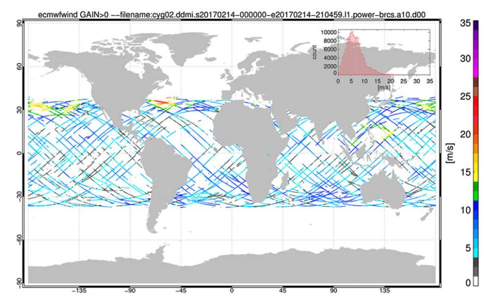
This map shows the coverage of ocean-surface wind measurements collected by one of the eight spacecraft that make up the CYGNSS constellation during the course of four orbits (approximately six hours) on Feb. 14, 2017. Blue values indicate relatively low wind speeds; while yellow, orange and red values indicate increasingly higher wind speeds. The highest wind speeds in this image are associated with a powerful extratropical cyclone that moved off the East Coast of North America.
This map shows the coverage of ocean-surface wind measurements collected by one of the eight spacecraft that make up the CYGNSS constellation during the course of four orbits (approximately six hours) on February 14, 2017. Blue values indicate relatively low wind speeds; yellow, orange, and red values indicate increasingly higher wind speeds. The highest wind speeds in this image are associated with a powerful extratropical cyclone that moved off the East Coast of North America. Credit: NASA/NOAA/University of Michigan.

To determine these differences in wind speeds, Lang combined CYGNSS observations with global precipitation measurements, as well as global/regional lightning datasets. He found that wind speeds near either type of precipitation system did not differ much—approximately 0.5 meters/per second or less. He also discovered that the difference in wind speeds depended on the source of the data. For example, CYGNSS data suggested non-thunderstorm winds were slightly stronger, while ASCAT data suggested the opposite. Lang attributed these differences to “lingering uncertainties between CYGNSS and ASCAT measurements in precipitation” and noted that, despite the differences, “both CYGNSS and ASCAT agreed that winds near precipitation systems, whether they produced lightning or not, were stronger than background winds by at least 1 meter per second.”

In a second 2020 paper published in the Journal of Geophysical Research Atmospheres, Lang, lead author Richard J. Blakeslee of Marshall, and others used LIS, GLM, and other data to analyze the performance and capabilities of the LIS on the International Space Station.

By comparing LIS data to that of similar instruments and datasets, including GLM data from GOES 16 and 17, the Global Lightning Detection Network (GLD360), and Earth Networks Global Lightning Network (ENGLN), Lang and his fellow researchers found that “the instrument met all of its major science objectives, including detecting lightning day and night, identifying the specific locations within storms that are producing lightning, millisecond timing accuracy, and high probability of detecting lightning.”

This conclusion is significant, for as Lang and his colleagues note, the instrument’s remarkable performance in orbit has “extended the long-term global climatology of lightning from space and provides more recent extension of the global record to higher latitudes” and its real-time data “have enabled new applications for the benefit of the public, including weather forecasting and public safety.”

In addition, LIS data benefit the public through their use in the calibration and validation of other lightning instruments, including the GLM. Such applications help ensure the data lightning instruments provide are of the highest quality for serving the public with accurate weather forecasts and warnings of severe weather. At the same time, these benefits would not be possible without NASA’s GHRC DAAC and its commitment to providing a comprehensive active archive of open and accessible data on lightning, tropical cyclones, storm-induced hazards, and the and physical processes that produce them.

Representative Data Products Used or Created:

From GHRC DAAC:

Other Data Products Used:

Read about the Research:

Amiot, C.G., Biswas, S.K., Lang, T.J., & Duncan, D.I. (2021). Dual-Polarization Deconvolution and Geophysical Retrievals from the Advanced Microwave Precipitation Radiometer during OLYMPEX/RADEX. Journal of Atmospheric and Oceanic Technology, 38(3): 607-628. doi:10.1175/JTECH-D-19-0218.1

Blakeslee, R.J., Lang, T.J., Koshak, W.J., Buechler, D., Gatlin, P., Mach, D.M., Stano, G.T., Virts, K.S., Walker, T.D., Cecil, D.J., Ellett, W., Goodman, S.J., Harrison, S., Hawkins, D.L., Heumesser, M., Lin, H., Maskey, M., Schultz, C.J., Stewart, M., Bateman, M., Chanrion, O. and Christian, H. (2020). Three Years of the Lightning Imaging Sensor Onboard the International Space Station: Expanded Global Coverage and Enhanced Applications. Journal of Geophysical Research Atmospheres, 125: e2020JD032918. doi:10.1029/2020JD032918

Lang, T.J. (2020). Comparing Winds near Tropical Oceanic Precipitation Systems with and without Lightning. Remote Sensing, 12(23), 3968. doi.org/10.3390/rs12233968

Explore more Data User Profiles

Last Updated