On Shaky Ground

The major earthquake in Haiti shifts thinking about disaster planning.
author-share

On January 12, 2010, Alex Fischer and his colleagues from the Center for International Earth Science Information Network (CIESIN) at Columbia University were at work in the United Nations Environment Programme (UNEP) office in Port-au-Prince, Haiti. At 4:53 p.m., the building started to shake. The group scrambled outside, struggling to stay upright amidst bucking floors and falling shelves. Fischer said, “There were six people on our team and in the office complex. It was incredible luck that all of us were fine, with no injuries.”

Ironically, at the time of the earthquake, Fischer had been working on a project to help the Haitian people prepare for and reduce their vulnerability to natural disasters, such as hurricanes, floods, and landslides. The project, called the Haiti Regeneration Initiative, started as a collaboration between the Earth Institute and UNEP, and focuses on the links between ecosystem degradation and natural disasters.


Image
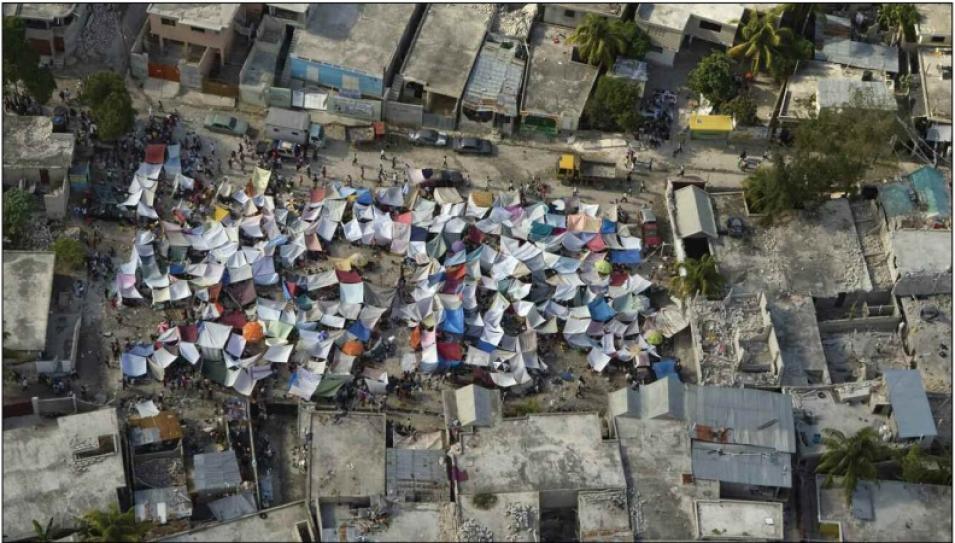
Makeshift shelters
Makeshift shelters dot Haiti after the January 2010 earthquake, as residents struggle to recover from its devastation. (Courtesy United Nations Development Programme)

Haiti is highly vulnerable to natural disasters. The island sits in a major storm track—in 2008 alone, the country was hit by four major hurricanes. But poverty and environmental degradation compound the problems resulting from storms.

The earthquake came as a surprise, even to researchers who study and plan for a multitude of possible natural disasters. By combining data on human and environmental factors, the researchers hoped that they could help Haiti not only prepare for disasters, but also reduce the impact of the disasters that do occur.

In the path of disaster

The earthquake gave Fischer and his colleagues, who usually work with demographic and scientific data, a first-hand perspective on the local realities of disaster. The next few days were a chaotic mess: without any medical supplies, and only basic first aid training, the scientists tried their best to help people injured by the quake, applying pressure to stop bleeding, splinting broken bones, and cleaning wounds with improvised supplies. Fischer said, “At the time of the earthquake, there was only one medical doctor in the compound. And for the first twenty-four hours, we didn’t have any medical supplies, only a few first aid kits.


Image
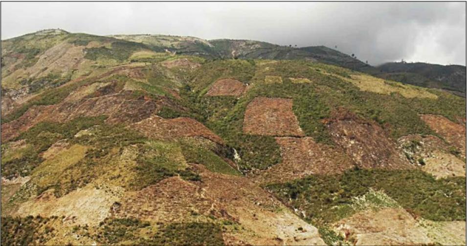
Cleared hillside
This cleared hillside in Haiti now lacks the vegetation that used to stabilize its slopes. The 2010 earthquake may have loosened the soil, making it even more vulnerable to erosion and landslides following heavy rains. It is an example of how a degraded environment can compound problems from natural disasters. (Courtesy A. Fischer, CIESIN)

After the earthquake, the immediate concern was to help the people who were affected— making sure they had food, water, and medical care they desperately needed. But as soon as they got back to the United States, Fischer and his research group started thinking about the future: what impacts would the quake have when hurricane season rolled around? Would the shaking that occurred in January 2010 increase Haiti’s vulnerability to other disasters later in the year? For example, the loss of data systems in the country meant that there could be less warning for hurricanes, floods, or landslides. Lacking adequate shelter, people displaced by the quake might be more at risk for injury from future disasters. And the quake itself may have shaken up hillsides, making them more likely to collapse when the rainy season hit.

“One of the questions right after the earthquake was, what areas could have been destabilized from the movement of the ground? Did the earthquake increase vulnerability for landslides during the rainy season?” Fischer said. Landslides are not the most obvious danger on the list of disasters that Haiti is vulnerable to. But when a hill suddenly collapses, it can destroy homes and roads, and kill people. Since 2003, at least eleven landslides have been reported in Haiti, killing ninety-eight people and injuring hundreds more.

Like a handful of sand

When the ground shakes in an earthquake, it destabilizes the soil and makes it more likely to slide. Dalia Kirschbaum, a researcher at NASA's Goddard Space Flight Center, combines satellite rainfall data with surface information to create a picture of possible landslide activity across the globe in near-real time. She said, “Think of a handful of sand. If you shake your hand, the sand will go all over the place. It’s the same thing with soil on a hill. If it shakes enough it can fall down the hill.” After the earthquake, Kirschbaum turned her attention to Haiti. In the aftermath of the earthquake, several teams of landslide experts used satellite and airborne imagery to identify slopes where soil and debris had been displaced. The researchers identified a number of landslides and rockfalls along the highway from Port-au-Prince to Jacmel and in smaller towns. However, there were surprisingly few landslides within the Port-au-Prince region during the earthquake. “As the rainy season comes, there will be more loose soil to mobilize into a landslide or debris flow,” Kirschbaum said.


Image
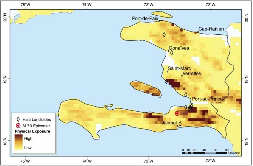
GPW Haiti
This map shows landslide physical exposure, identifying areas with both a high risk for landslide and with dense human populations. Sites of past landslides are marked with green diamonds, and a red dot marks the epicenter of the January 2010 earthquake. Brown colors indicate areas of high risk of human exposure to landslides. (Population data from SEDAC’s Gridded Population of the World; map courtesy D. Kirschbaum)

In the months following the earthquake, Kirschbaum worked on a series of maps to identify where people in Haiti are most vulnerable to landslides. Landslides are notoriously difficult to predict, particularly using broad-scale satellite data. “You are looking at a very small-scale feature that is barely resolvable in satellite imagery. You’re not looking at a hurricane where it’s hundreds of kilometers across and you can track it with satellite images,” Kirschbaum said. But in Haiti, where there is little ground data on soil moisture or rainfall, satellite data may be the best tool.

Kirschbaum combines satellite data on rainfall with maps of land cover type and gridded population data from NASA's Socioeconomic Data and Applications Center (SEDAC). Kirschbaum said, “The approach we’re taking is statistical and empirical. We look at satellite data to hypothesize the conditions in which landslides might be triggered. Then we look at where the people are. Where these two data sets intersect is where the populations will be most susceptible to landslides.”

Knowing where people are concentrated is key, and means knowing where a landslide could have the largest impact. But human presence can also affect the stability of slopes. Kirschbaum said, “There’s a feedback mechanism: people tend to cause more landslides because of their activities.” On steep slopes the construction of roads and buildings can weaken an already precarious hillside, particularly if the structures are not built according to engineering standards. And extreme deforestation in the Haitian countryside has made the whole country more vulnerable to landslides, since there are fewer roots to protect the slope and absorb water during a major rainfall.

Human dimensions of disaster

Fischer and other researchers are now focusing on the links between people, their environments, and the impact of natural disasters in Haiti. Fischer said, “Haiti is even more vulnerable to disasters because they have poor construction standards, because they don’t have proper communication systems, and they don’t have proper shelters to evacuate to.”

Inadequate construction standards make buildings more likely to collapse when hit by strong winds or flooding. Lack of an emergency warning system or adequate public shelters means that people have little warning of a storm and nowhere to go when it strikes. Those problems not only have the potential to increase the impact of disasters; they also confound the effort to rebuild and prepare for future disasters.

Kirschbaum said. “What’s sorely needed in Haiti is not just hazard assessment, but a focus on the social dimension. How can we take the data we have and move it into action?”

The earthquake also refocused researchers like Fischer. “The earthquake was unexpected. Nobody was talking about earthquake risk in Haiti prior to January 2010,” Fischer said. “So it completely changed our perspective on disaster risk and what was needed for preparation.” Now, on top of hurricanes and floods, the researchers have to consider collapsed buildings, destroyed roads and communications, extensive debris blocking river channels and flood plains, and other problems that occur after an earthquake, such as landslides triggered by rainfall. They also think about how a slow recovery from the earthquake could affect response to future disasters. Fischer said, “The earthquake delayed our initial work, but it also broadened our focus into a national and regional scale, and made us think about how we could scale up local programs into broader risk management.”

References

Hong, Y., R. Adler, and G. Huffman. 2007. Use of satellite remote sensing in the mapping of global landslide susceptibility. Natural Hazards, doi:10.1007/s11069-006-9104-z.

Kirschbaum, D.B., R. Adler, Y. Hong, and A. Lerner-Lam. 2009. Evaluation of a preliminary satellite-based landslide hazard algorithm using global landslide inventories. Natural Hazards and Earth System Sciences 9:673-686.

Smucker, G.R. (ed.), M. Bannister, H. D'Agnes, Y. Gossin, M. Portnoff, J. Timyan, S. Tobias, and R. Toussaint. 2007. Environmental Vulnerability in Haiti: Findings and Recommendations. United States Agency for International Development.

For more information

NASA Socioeconomic Data and Applications Center (SEDAC)

Center for International Earth Science Information Network (CIESIN)

CIESIN Haiti Regeneration Initiative

Haiti Regeneration Initiative

About the remote sensing data
Data set used Gridded Population of the World
Spatial resolution 2.5 minutes, latitude/longitude
Temporal resolution 1990-2015, every five years
Parameter Human population density
DAAC NASA Socioeconomic Data and Applications Center (SEDAC)
Last Updated