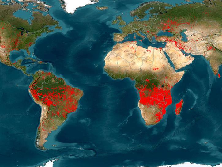
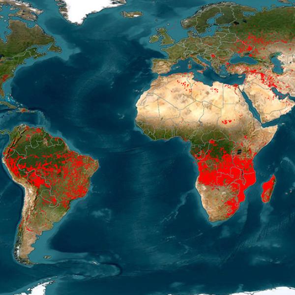
Each year, forest fires consume millions of acres of land, destroying thousands of homes and properties in the Western United States and around the world. Fires like the 100,277-hectare Lutz Creek fire in British Columbia in August 2018 and the Camp Fire in California in November 2018, which burned more than 142,000 acres, exact a costly economic and human toll. The need to study the relationships between environmental factors and fires to minimize risk is critical.
Discover Fire and Related Data
Active Fire/Thermal Anomalies
NASA provides data that can be used to detect active fires and thermal anomalies, such as volcanoes, and gas flares. These data are useful for studying the spatial and temporal distribution of fire, to locate persistent hot spots such as volcanoes and gas flares, and to locate the source of air pollution from smoke that may have adverse human health impacts.
- Discover Fires/Thermal Anomalies Data in Fire Information for Resource Management System (FIRMS)
- Discover Fires/Thermal Anomalies Data in Earthdata Search
- Fire Carbon Emissions Estimates at NASA's Oak Ridge National Laboratory Distributed Active Archive Center (ORNL DAAC)
- Fire Extent/Severity Data at ORNL DAAC
- Fire/Thermal Anomalies Data at NASA's Land Processes DAAC (LP DAAC)
- Visualize Fires/Thermal Anomalies Data in Worldview
Data Tutorials/Recipes
- Getting Started with Moderate Resolution Imaging Spectroradiometer (MODIS) Thermal
- Anomalies and Fire Data: All About Accessing Data
- Getting Started with MODIS Thermal Anomalies and Fire Data: Interpreting Quality Information
- Getting Started with MODIS Thermal Anomalies and Fire Data: Using the Data
- Learn about Satellite Detections of Fire in Worldview
- Tutorials/Recipes for LP DAAC Data
- Tutorials/Recipes for ORNL DAAC Data
Data User Guides
- MODIS Active Fires Data User Guide
- Visible Infrared Imaging Radiometer Suite (VIIRS) Active Fires Data User Guide
Explore Fire Events in Worldview
- California and British Columbia Wildfires (Summer 2018)
- Camp Fire (November 2018)
- 2021 Satellite Detections of Fire
Webinars
Land Dynamics and Burned Areas
Land dynamics, including land cover types, vegetation health, and land surface temperature are important in predicting the severity of fire events. These measurements, along with burned area, help in the assessment of post-fire impacts.
Burned Areas
- Burned Area Data at LP DAAC
- Burned Area Data at ORNL DAAC
- Discover Burned Area Data in Earthdata Search
- MODIS Burned Area Product User Guide
- Visualize Burned Area Data in FIRMS
Land Cover
- Discover Land Cover Data in Earthdata Search
- Land Cover Data at LP DAAC
- Land Cover Data at ORNL DAAC
Land Surface Temperature
- Discover Land Cover Data in Earthdata Search
- Land Cover Data at LP DAAC
- Land Cover Data at ORNL DAAC
Data Tutorials/Recipes
- Getting Started with MODIS Land Surface Temperature Data: Interpreting Quality Information
- Getting Started with MODIS Land Surface Temperature Data: Using the Data
- Getting Started with MODIS Version 6 Land Surface Temperature Data: All About Accessing Data
Vegetation
- Discover Vegetation Indices Data in Earthdata Search
- Vegetation Data at LP DAAC
- Vegetation Data at ORNL DAAC
- Visualize Vegetation Indices Data in Worldview
Data Tutorials/Recipes
- Accessing Data through ORNL DAAC Web Services on Github
- An Introduction to NASA MODIS Version 6 Land Data
- Getting Started with MODIS Version 6 Vegetation Indices Data : Accessing the Data
- Getting Started with MODIS Version 6 Vegetation Indices Data: Interpreting Quality Information
- Discover Vegetation Indices Data in Earthdata Search
- Getting Started with MODIS Version 6 Vegetation Indices Data: Using the Data
Webinars
- ECOsystem Spaceborne Thermal Radiometer Experiment on Space Station (ECOSTRESS: NASA's Next-Generation Mission to Measure Evapotranspiration from the ISS
- Exploring Earth’s Land Surface with the joint NASA/NOAA Suomi National Polar-orbiting Partnership (Suomi NPP) VIIRS Land Data
- ORNL DAAC MODIS and VIIRS Data Tools and Services at your Fingertips
- Using NASA’s Application for Extracting and Exploring Analysis Ready Samples (AppEEARS) to Slice and Dice Big Earth Data
Lightning
Wildland fires are most often started by humans, but lightning strikes have been the cause of some of the worst wildfires in the western United States and around the world. Wildfires caused by lightning often occur in remote locations that are not easily accessible.
- Discover Lightning Data in Earthdata Search
- Lightning Data at NASA's Global Hydrometeorology Resource Center DAAC (GHRC DAAC)
- Visualize Lightning Data in Worldview
Data Tutorials/Recipes
- ISS LIS Lightning Flash Location Quickview using Python and GIS
- Using ArcGIS to Convert LIS Very High Resolution Gridded Lightning Climatology NetCDF Data to GeoTIFF Format
Webinars
- Discover International Space Station (ISS) Lightning and Associated Validation Data from Geostationary Operational Environmental Satellite-R (GOES-16)
- Learn How to Subset Ozone Monitoring Instrument (OMI) Data with NASA's Goddard Earth Sciences Data and Information Services Center (GES DISC) Level 2 Data Subsetter
- Striking New Spatial Bounds Using ISS Lightning Imaging Sensor (LIS) Data
Precipitation
By monitoring seasonal variations in precipitation (rain and snow) fire managers are better able to predict and evaluate when and where a wildfire may develop, how severe the fire may become, and the rate at which a wildfire spreads.
- Citizen Science on Snow
- Discover Rain/Snow Data in Earthdata Search
- Precipitation Data at GES DISC
- Rain/Snow Data at GHRC DAAC
- Snow Data at NASA's National Snow and Ice Data Center DAAC (NSIDC DAAC)
- Visualize Rain/Snow Data in Worldview
Data Tutorials/Recipes
- Daymet Single Pixel Data Extraction—Web Services
- How to Import Modern Era-Retrospective Analysis for Research and Applications (MERRA) Surface Product Data into ArcGIS
Webinars
- Data Access and Visualization of Model Data at GES DISC
- NetCD-what? An Ecologist’s Guide to Working with Daymet and other NetCDF-formatted Data
- Tropical Rainfall Measuring Mission (TRMM) and Global Precipitation Measurement (GPM) Precipitation Products and Services at GES DISC
Smoke Plumes and Air Quality
Air quality forecasters use near real-time (NRT) data from NASA's Land, Atmosphere Near real-time Capability for EOS (LANCE) to improve some local and national air quality forecasts. Smoke plumes from agricultural burning and wildland fires can be a source of air pollution that may have adverse impacts on human health.
Aerosol Index
- Aerosol Index (AI) Data at GES DISC
- AI Data at NASA's Atmospheric Science Data Center (ASDC)
- AI Data at NASA's Level 1 and Atmosphere Archive and Distribution System DAAC (LAADS DAAC)
- Discover Aerosol Index in Earthdata Search
- Near real-time AI Data from LANCE
- Visualize Aerosol Index in Worldview
Aerosol Optical Depth (AOD)
- AOD Data at ASDC
- AOD Data at GES DISC
- AOD Data at LAADS DAAC
- AOD Data at LP DAAC
- AOD Data at NASA's Ocean Biology DAAC (OB.DAAC)
- AOD Data at NASA's Socioeconomic Data and Applications Center (SEDAC)
- Citizen Science on AOD
- Discover AOD in Earthdata Search
- Visualize AOD at Worldview
Carbon Monoxide (CO)
- CO Data at ASDC
- CO Data at GES DISC
- Discover CO Data in Earthdata Search
- Visualize CO Data in Worldview
Smoke Plumes
Sulfur Dioxide (SO2)