NASA Addresses U.S. Earth Observation Satellite Needs

Assessment of the 2020 Satellite Needs Working Group (SNWG) survey identified 10 activities to address Federal agency satellite needs.

NASA will undertake 10 activities to meet the Earth observation satellite needs of U.S. Federal agencies. These needs were identified through the 2020 Satellite Needs Working Group (SNWG) biennial survey of Federal agencies and represent high-profile needs for satellite Earth observation data. The SNWG is an initiative of the U.S. Group on Earth Observations (USGEO), which helps coordinate U.S. civilian satellite Earth observations. The SNWG Management Office (SNWG MO) at NASA’s Interagency Implementation and Advanced Concepts Team (IMPACT) will oversee these activities.

Activities identified in the 2020 SNWG survey are:
  1. Image
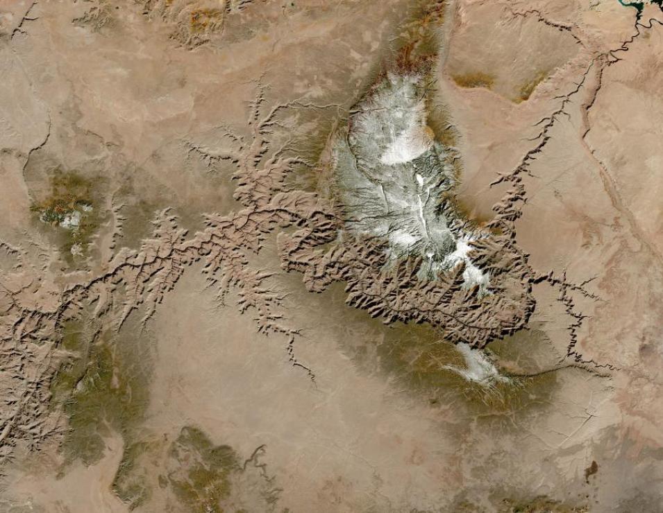
    HLS image of the Grand Canyon acquired February 6, 2021. Credit: NASA Worldview.
    An outcome of NASA’s 2016 SNWG Assessment was production of a global Harmonized Landsat Sentinel-2 (HLS) surface reflectance product, which is currently operational. Building on this successful SNWG activity, NASA will derive a suite of global vegetation indices from a combination of HLS surface reflectance bands. Surface reflectance information is routinely used to assess vegetation type, long-term changes in land use, disasters, and season health. The HLS vegetation indices suite will benefit agencies across the U.S. Government that would otherwise be processing these data separately.
  2. Recognizing a multi-agency need to improve the U.S. Government’s ability to detect and forecast crucial air quality parameters in poorly sampled locations, NASA will expand the Pandora air quality sensor network to include select U.S. embassies in countries that have significant air quality issues, as well as select agricultural/rural sites within the U.S. These new Pandora air quality observations will be integrated into NASA’s Goddard Earth Observing System-Composition Forecast (GEOS-CF) model to provide more precise air quality forecasts at international and domestic sites of interest to SNWG agencies.
  3. Observations of the highly dynamic properties of the planetary boundary layer (PBL), the lowest layer of the atmosphere in contact with Earth’s surface, are needed for a variety of weather forecasting applications. Both hyperspectral sounders and Global Navigation Satellite System-Radio Occultations (GNSS-RO) measure temperature, moisture, and other variables throughout the atmosphere. NASA will combine hyperspectral sounder and commercial GNSS-RO data into a merged global product that will advance PBL process science and improve weather forecasting applications.
  4. NASA plans to produce new hourly, near real-time air quality products from the upcoming Tropospheric Emissions: Monitoring of Pollution (TEMPO) mission. TEMPO will provide key measurements of trace gases over North America that are important to the air quality forecasting and regulatory communities. Expediting select TEMPO products to near real-time availability will assist in the forecasting and modeling efforts of multiple agencies. (Note: This activity requires an interagency partnership that is still under discussion.)
  5. Sea surface salinity is widely used in various environmental and ecological forecasts as well as in coupled ocean-atmosphere models. NASA supports production of two sea surface salinity products from the Aquarius and Soil Moisture Active Passive (SMAP) missions. The 2020 SNWG Assessment determined that adding a sea ice flag to these existing products will benefit agencies needing observations close to the sea ice edge. NASA will implement this activity with data distribution through the Physical Oceanography Distributed Active Archive Center (PO.DAAC).
  6. A frequent request from Federal agencies in the 2020 SNWG survey is for high-resolution, optical Earth observation data. Agencies expressed widespread interest in obtaining access to commercial imagery through NASA’s agreements. The requests included reducing the latency of the available data, developing new research and operational products, and exploring new opportunities for research and applications. In response, NASA has uplifted its existing license for data from PlanetScope and RapidEye to permit U.S. Government-wide access and distribution through the agency’s Commercial Smallsat Data Acquisition (CSDA) program, where applicable. CSDA was established to identify, evaluate, and acquire satellite data from commercial sources that support NASA’s Earth science research and application goals.
  7. Image
    Shaded relief rendering of EarthDEM data showing the Virgin River, Nevada. DEM derived from Maxar imagery. Credit: EarthDEM Project.
    Earth’s topography is constantly changing through processes such as volcanoes, geohazards, mining, subsidence, and urban growth. Digital elevation models (DEMs) provide high-resolution depictions of the land surface and are needed by many U.S. Government agencies for identifying rapid land surface changes. NASA will distribute EarthDEM strip products for locations where Maxar’s WorldView satellites collected stereo imagery. These EarthDEM products will be available to agencies through CSDA.
  8. Hyperspectral observations of the surface reflectance spectrum offer opportunities to test and develop new algorithms focused on land surface vegetation, water quality, and others. NASA’s assessment determined that over half of the agencies who submitted SNWG surveys will benefit from hyperspectral products from the German Aerospace Center (DLR) Earth Sensing Imaging Spectrometer (DESIS), which is installed on the International Space Station. CSDA has renewed its license for scientific use of DESIS data to continue the availability of these valuable data to the U.S. Government.
  9. Global Positioning System-Radio Occultation (GPS-RO) data provide valuable information about the vertical distribution of atmospheric temperature and moisture and are frequently used in data assimilation and numerical weather prediction. Federal agencies requested GPS-RO data for these purposes and to further explore the value of these data to meet their needs. CSDA has uplifted its existing license for commercial GPS-RO data from Spire to permit scientific use throughout the U.S. Government. The combination of Spire and NASA GPS/GNSS-RO data with atmospheric sounder measurements will support the merged planetary boundary layer product described in Activity #3, above.
  10. More than half the agency needs identified in the SNWG assessment process can be partially met using commercial Earth imagery. Agencies further requested discovery and access to commercial data through NASA’s Earthdata Search web interface. NASA will implement this activity through CSDA. Agencies will be able to discover both NASA and commercial data using the same search tool and will be able to access these datasets subject to the terms of End User License Agreements (EULAs).

Information and updates on past activities undertaken by NASA to meet SNWG agency needs can be found on the Earthdata Stakeholder Engagement Program (SEP) page. The SEP is part of NASA’s SNWG Management Office and brings together capabilities from across NASA and other partner organizations to assist with SNWG product training and outreach.