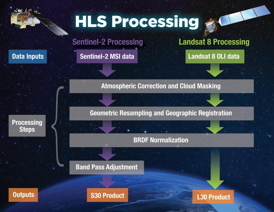
The Harmonized Landsat Sentinel-2 (HLS) project, which uses data from the joint NASA-USGS Landsat 8 and the European Space Agency’s (ESA) Sentinel-2A and Sentinel-2B satellites to generate a harmonized, analysis-ready surface reflectance data product available every two to three days, is an initiative of firsts. Its data products are the first to be used together, as if they come from a single instrument aboard the same satellite, and it is the first major Earth science dataset in NASA’s Earth Observing System Data and Information System (EOSDIS) collection hosted fully in the commercial cloud.
In the following interview, Dr. Jeff Masek, Principal Investigator on the HLS project, discusses the origins of the HLS project, the significance of the recent release of provisional HLS data, and what the project has in store for the future.
Can you discuss the impetus or need for the HLS product and how it came about?
We started the HLS project around 2014, before the launch of ESA's Sentinel -2 satellite, because there is just a general desire in the land science community for more frequent observations with the resolution that you get from a Landsat kind of system. We’re used to having daily data from MODIS (the Moderate Resolution Imaging Spectroradiometer instrument, aboard NASA’s Aqua and Terra satellites) or VIIRS (Visible Infrared Imaging Radiometer Suite instrument, aboard the joint NASA/NOAA Suomi National Polar-orbiting Partnership and NOAA 20 satellites), which is half-kilometer to one-kilometer resolution, but people discovered they could do a lot of the same science, but at the scale of fields and forest plots, individual blocks and cities, and so forth if they have the spatial resolution and daily data. We realized that, with Landsat, you only get an image every 16 days from one satellite and every 8 days from two satellites, which is what we usually have. Then we had the European Sentinel-2 System coming on, which offers data every 10 days from one satellite and every 5 days from two satellites. If you put these together, you have close to the daily observation scheme that people have been looking for. So, that was the impetus back in 2014, getting ready for the launch of Sentinel-2 and starting to think about putting these two data streams together and making it easy for users to do that.
As we were prototyping HLS data, the Satellite Needs Working Group (SNWG) came along. This SNWG is an interagency effort to collect the needs that federal agencies have for space-based, Earth observation data, present it to NASA and ask, “What can you do to help us collect this type of information?” In some cases, it’s sort of easy, low-hanging fruit because the data they need is already something we’re collecting and it’s just a matter of creating a new product or putting a couple of different [data] sources together. That was the case with HLS. The USDA said, “We would really like to look at within-year variation in crops and vegetation indices to assess crop type, and if we could put Sentinel-2 and Landsat together, that would be the ideal combination.” So, NASA said, “We’re already kind of working on that. Let’s accelerate that effort and expand it to a prototype with a global product.”
Beyond requesting data, what other roles did federal agencies played in the development of HLS?
The big partner in all of this is the USGS, because they provide the Landsat data. We’ve been working with them directly because they have a long-term interest in doing this kind of harmonization among datasets. In terms of consumers of the HLS data, the USDA is the big one because they need to be looking at crop status every few days to really track things. So, we worked with Martha Anderson and Feng Gao of the USDA’s Hydrology and Remote Sensing Laboratory in Beltsville, Maryland), which has been using the HLS product to inform its analysis of crop productivity through the growing season and make maps of planting date and initial emergence date, which is one of the variables that’s hard to get to from the existing satellite record.
In terms of collecting user needs, we engaged the USDA in various workshops and solicited user comments for the prototype stage before it got to NASA's Earth Science Data and Information System (ESDIS) implementation, so we have a pretty good feeling about what people are looking for from that activity.
