Lightning Imaging Sensor’s Nearly 25-Year Data Record Ends

The Lightning Imaging Sensor measured the amount, rate, and radiant energy of lightning around the globe both day and night.
This graphic shows the orbital inclination of the Lightning Imaging Sensor aboard the International Space Station, which goes up to about 52 degrees North and South. The colored dots on the graphic indicate flashes of lightning detected by the sensor on October 5, 2023. Yellow, orange, and red dots indicate the greatest number of flashes, while pink and purple represent the least.
Image Caption

The Lightning Imaging Sensor (LIS) on the International Space Station records the time of a lightning event, measures the lightning's radiant energy, and estimates the location during both day and night conditions with high detection efficiency. Gray lines indicate LIS viewing area; colors indicate number of detected flashes. Credit: NASA's GHRC DAAC.

At any given moment, more than 2,000 thunderstorms producing on the order of 50 lightning flashes per second are active throughout the world. That’s a lot of lightning, and while no single space-based instrument could ever hope to capture it all, one instrument—the Lightning Imaging Sensor (LIS) on the International Space Station—has given scientists a more expansive look at global lightning than they’ve ever had.

“Even though we have the Geostationary Lighting Mapper (GLM) [aboard NOAA’s GOES-R series satellites] and Europe just launched their version of it, the Lightning Imager on their Meteosat Third Generation satellite, LIS on the space station can see parts of the world that are not observed by those geostationary instruments,” said Dr. Geoffrey Stano, chief scientist at NASA’s Global Hydrometeorology Resource Center Distributed Active Archive Center (GHRC DAAC).

LIS detects the distribution and variability of total lightning, including cloud-to-cloud, intra-cloud, and cloud-to-ground lightning, and it measures the amount, rate, and radiant energy of lightning during both day and night. Two LIS instruments were built in the 1990s, one for the Tropical Rainfall Measuring Mission (TRMM) and a spare that was kept in storage. The TRMM LIS operated successfully for more than 17 years, from launch in 1997 until April 2015. After TRMM ceased operations, the spare LIS was installed on the International Space Station in February 2017 for what was expected to be a two- to four-year mission. Now, more than six years later, NASA plans to decommission the space station's LIS by the end of 2023.

“The LIS instrument will be decommissioned sometime in [late-2023]. It just depends on when the SpaceX mission to the [International Space Station] occurs,” said Leigh Sinclair, team lead for GHRC's Data Management Group and Lightning Team. “If [the mission] gets pushed back, then the decommissioning will be pushed back.” [Editor's note: The SpaceX mission to the International Space Station launched on Thursday, November 9, and docked with the space station on Saturday, November 11.]

On whatever day the decommissioning occurs, it will mark the end of nearly 25 years of data from the two LIS sensors.

“If it had not been for the International Space Station, this instrument would never have flown, but because the space station gave it a home, we now have an additional six years of data to extend the history from the original LIS mission aboard TRMM,” Stano said. “Aside from a gap of about two years between 2015 and 2017, you pretty much have continuous observations from 1997 through 2023 between the TRMM LIS and the [space station] LIS, so you’re looking at about almost a quarter-century of data, which is really impressive for this style of observation.”
An artist's illustration of the Tropical Rainfall Measuring Mission satellite in space over a hurricane.
Image Caption

An artist's illustration of the TRMM satellite in space above a hurricane. Credit: NASA's Global Precipitation Measurement (GPM) mission team.

In addition to extending the length of the LIS mission, the space station has a wider orbital inclination than TRMM, which enabled its LIS to capture lightning data over a larger portion of Earth’s surface.

“[The space station] has an orbital inclination that goes up to about 52 degrees North and South. Before 2017, we really didn’t have space-based observations for a good amount of time in some areas because the TRMM LIS went to only 35 degrees North and South,” Stano said. “The data from the LIS on the [space station] allows us to compare it with observations from an earlier instrument called the Optical Transient Detector (OTD), which could also [detect lightning] at those higher latitudes.”

The LIS data record is the only one of its kind available from a space-based instrument, and for lightning researchers like Sinclair and Stano, having nearly 25 years of data gives them the opportunity to look at patterns of lightning or see what’s happening in a particular region over a period of time. Of course, the GLM and Lighting Imager are expected to provide such long-term data records as they continue on in their missions, but in Stano’s words, “it’s still going to take those missions many years to match the longevity of LIS.”

During normal operations, GHRC received data from the space station LIS every two minutes and used them to produce six data products:

All of these products can be used to detect the distribution and variability of total lightning occurring in Earth’s tropical and subtropical regions, as well as for severe storm detection and analysis and lightning-atmosphere interaction studies. The Non-Quality Controlled data are produced by the DAAC’s NRT processing system, which takes the two-minute files and combines them into a daily orbit product.

Science Data (i.e., Quality Controlled data) refers to data that have been reviewed by a member of GHRC’s Lightning Team. Once the data have been quality controlled, the Non-Quality Controlled data are removed from the GHRC archive. The Backgrounds are filtering products that can be used by anyone who wants to quality control their own data. In the quality-controlled Science Data, this already has been done.

According to Sinclair, once the LIS aboard the space station is decommissioned, all its data will be quality controlled.

“Once that’s done, it’s up to the science team to decide what they want to do. If they want to update the code and release a new version of the quality-controlled data, we will do so,” she said.

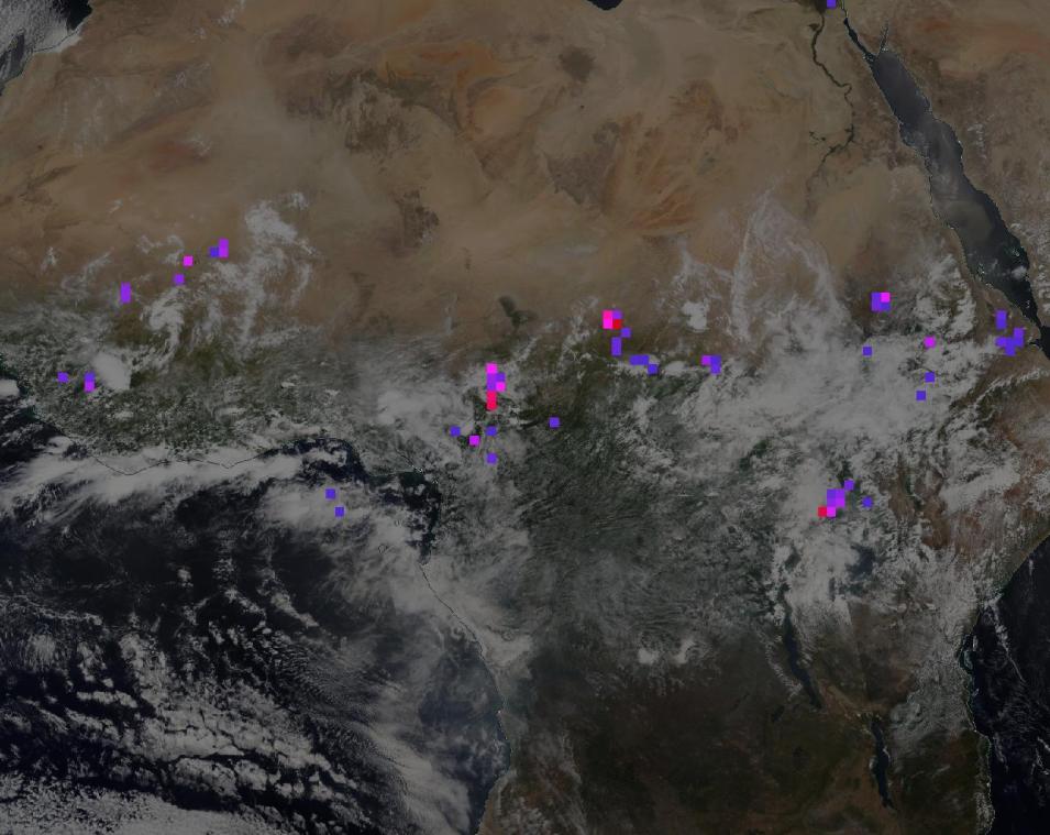
This image from NASA Worldview shows ISS LIS Flash Count data (i.e., the pink, purple, and red dots), which provide the number of lightning flashes recorded by the LIS aboard the ISS. Red dots indicate high numbers of lightning flashes (greater than or equal to 20), while purple dots indicate the fewest flashes.
Image Caption

This NASA Worldview image of central Africa shows space station LIS Flash Count data (i.e., the pink, purple, and red dots), which provide the number of lightning flashes recorded by the LIS. Red dots indicate high numbers of lightning flashes (greater than or equal to 20), while purple dots indicate the fewest flashes. Explore this image in NASA Worldview. Credit: NASA Worldview. 

Further, because the LIS has been a major component of the GHRC and one of its flagship instruments for many years, Stano expects the DAAC and LIS Science Team will continue to work together.

“We’ll likely be talking to the science team for years to come. There might be specific things that come out of that, such as newer versions of the LIS data, and GHRC might also expand some of its work on user services tools,” he said. “For example, we’ve been bringing the new data into a system called Lightning Dashboard, and so we’ll provide ways to visualize and utilize these data, which have been one of our top 10 datasets.”

LIS data have a range of applications within the meteorology and remote sensing communities, and have been used not only scientifically, but also operationally.

“Operationally, LIS data have been used by the Aviation Weather Center, which is responsible for aviation around much of the globe. When it’s available, it can help provide details about lightning in a particular location,” Stano said. “It’s also been used for looking at longer-term studies of precipitation. With TRMM, you had a spaceborne radar in conjunction with a spaceborne lightning detector, so you could compare what could be seen on radar with what could be seen by satellite.”

Further, because the two LIS instruments have such a long data record and are so well understood by members of the lightning science community, the data have played an important part in the calibration and validation of other instruments, including GLM.

“You can take a ground-based network and a space-based platform, such as the GLM, and compare them both to a coincident pass of LIS data to get a good understanding of what are the biases and the issues and the detection efficiencies of those other instruments," said Stano. "That’s an exciting and significant component of the LIS legacy.”

Details

Last Updated

Published

Data Center/Project

Global Hydrometeorology Resource Center DAAC (GHRC DAAC)