FLASH—A New Source for Global Lightning Data is Now Available

Provisional data from the Lightning Imaging Sensor aboard the International Space Station - LIS (ISS) are now available through NASA's GHRC DAAC and LANCE.
LIS logo

A lightning flash is an amazing force of nature. Along with contributing to more than 24,000 fires each year leading to about $407 million in damages, these electrical discharges can heat the air they pass through to temperatures as high as 50,000 degrees Fahrenheit, according to the National Weather Service - that’s about five times hotter than the surface of the sun. Knowing where and when lightning is occurring and being able to track the movement of severe storms with intense lightning, especially over oceans and other remote areas, is vital for protecting lives and property.

Provisional near real-time (NRT) and non-quality-controlled (NQC) standard data products from a new Lightning Imaging Sensor (LIS) installed aboard the International Space Station (ISS) in late February 2017 are now available through NASA’s Global Hydrometeorology Resource Center Distributed Active Archive Center (GHRC DAAC) and Land, Atmosphere Near real-time Capability for EOS (LANCE) system. These data are available in both HDF-4 and netCDF-4 formats; the LIS (ISS) data record starts on March 1, 2017.

Image
ISS LIS NRT image
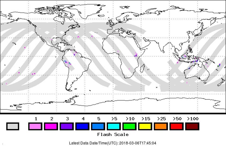
ISS LIS Near Real Time 12 Hour Browse Image from March 6, 2018, showing detected lightning flashes superimposed on the instrument’s orbital track (gray lines). Colors indicate the number of flashes detected. Image provided by the GHRC DAAC; DOI: 10.5067/LIS/ISSLIS/DATA205. Accessed March 6, 2018.

LIS NRT data are available rapidly after an observation (generally within two minutes), and are an excellent resource for applications requiring low data latency, such as tracking on-going severe storms or tracking lightning over oceans and other data-sparse regions. LIS standard data products, on the other hand, are created daily after all raw observations for the day have been acquired, which means they will be more complete than NRT data. It is important to note that the NQC standard data products have not undergone a review to assure data quality.

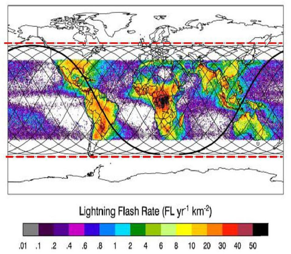
To be accurate, the LIS (ISS) is not really a “new” instrument. In fact, it is the back-up LIS that is identical to the first LIS that orbited aboard the Tropical Rainfall Measuring Mission (TRMM), operational 1997 to 2015. The TRMM LIS observed lightning flashes in the tropics between roughly 38˚ north and south of the equator. Data from the TRMM LIS complemented lightning data from the Optical Transient Detector (OTD), operational 1995 to 2000, which was a space-qualified engineering model of the LIS that was flown aboard Orbital Science Corporation’s Microlab-1 satellite (this name was later changed to OrbView-1). Data from the TRMM LIS and the OTD established that about 45 lightning flashes occur over Earth every second, with about one-third (15 flashes per second) striking the planet as discharges to ground; the remaining flashes are cloud flashes.

Image
TRMM vs. ISS coverage
A comparison of TRMM LIS coverage (colored areas between roughly 38˚ north and south latitude) and the increased global coverage of the ISS LIS (dashed red lines, roughly 48˚ north and south latitude). NASA GHRC DAAC image.

The LIS (ISS) not only continues the climatological data record started by the TRMM LIS and the OTD, it enhances this record by sensing lightning over a much greater area. By sensing lightning between approximately 48˚ north and south of the equator, the LIS (ISS) is able to detect 98% of Earth’s annual lightning, and provides new insights about thunderstorms occurring in the climatologically sensitive mid-latitudes. In addition, LIS (ISS) NRT data will be valuable as an aid for short-term weather and aviation forecasts, warnings, and situational awareness in data-sparse regions, such as over oceans.

By providing lightning flash data for most of Earth’s population rapidly after a detected flash, the ISS LIS provides emergency managers and meteorologists with a powerful new tool for protecting lives and property. For researchers, ISS LIS data not only continue a valuable data record dating back to 1995, but provide new perspectives on an amazing force of nature affecting the planet.

Additional Resources

Blakeslee, R. and Koshak, W. (2016). “LIS on ISS: Expanded Global Coverage and Enhanced Applications.” The Earth Observer, 28(3): 4-14. Available online at https://eospso.nasa.gov/sites/default/files/eo_pdfs/May_June_2016_color%20508.pdf#page=4

LIS (ISS) Provisional NQC data sets, doi: 10.5067/LIS/ISSLIS/DATA204

LIS (ISS) Provisional NRT data sets, doi: 10.5067/LIS/ISSLIS/DATA205

LANCE LIS (ISS) data