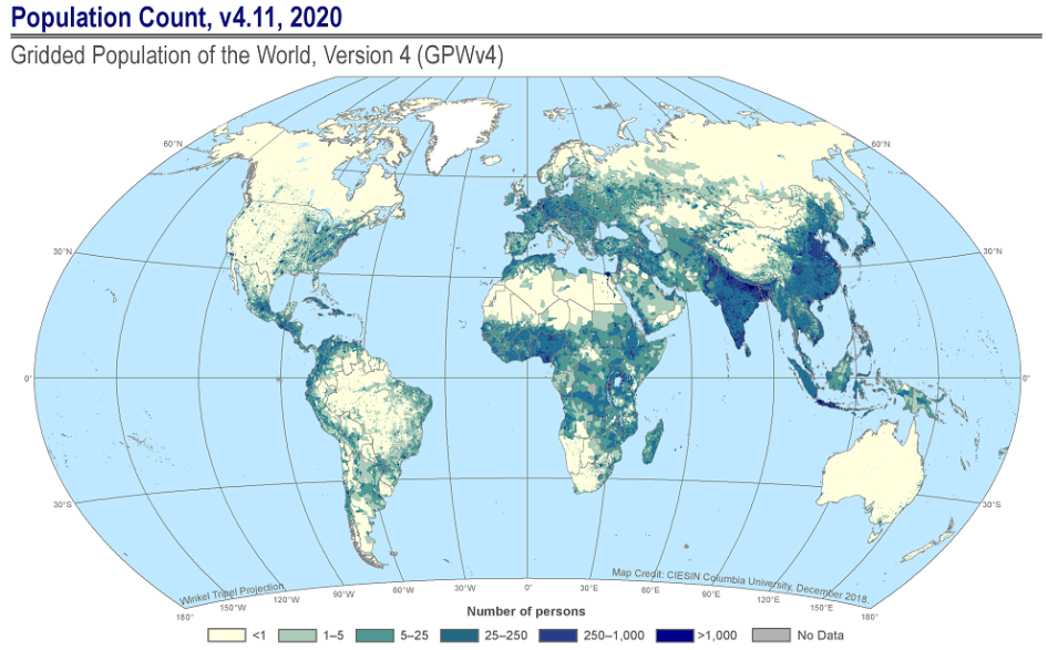
NASA’s Socioeconomic Data and Applications Center (SEDAC) recently released an update that adds numerous enhancements to its flagship Gridded Population of the World (GPW) data collection.
New Update to SEDAC’s Gridded Population of the World (GPW)
Population Count 2020 is one of nine GPWv4.11 Data Sets. The Population Count Data Set consists of estimates of human population consistent with national censuses and population registers for 2000, 2005, 2010, 2015, and 2020. Data source: CIESIN, Columbia University. 2018. GPWv4: Population Count, Revision 11. Palisades, NY: NASA SEDAC. DOI: 10.7927/H4JW8BX5.
GPWv4.11 is the first GPW update in more than a year. Data collection enhancements include extending the final gridded data to a full global extent, adding two new classes (Total Land Pixels and Ocean Pixels) to the Water Mask, and reprocessing the National Identifier Grid to remove artifacts from inland water. For detailed information, please visit SEDAC’s GPWv4 Documentation page.
The nine Data Sets comprising GPWv4.11 include 35 maps. In addition, Web Mapping Services (WMS) for 78 layers from the Basic Demographic Characteristics dataset have been published and the existing 26 WMS services in the GPWv4 collection have been updated with GPWv4.11 data.
SEDAC’s Gridded Population of the World provides a spatially disaggregated population layer that is compatible with datasets from social, economic, and Earth science disciplines as well as with remote sensing. It provides globally consistent and spatially explicit data for use in research, policy-making, and communications. Initially released in 1995, version 4 (v4.0) of the collection was published in 2016.
SEDAC is NASA's Earth Observing System Data and Information System (EOSDIS) Distributed Active Archive Center (DAAC) responsible for archiving and distributing socioeconomic data in the EOSDIS collection, and is hosted at Columbia University’s Center for International Earth Science Information Network (CIESIN). SEDAC synthesizes Earth science and socioeconomic data and information in ways useful to a wide range of decision makers and other applied users, and serves as an “Information Gateway” between the socioeconomic and Earth science data and information domains.
