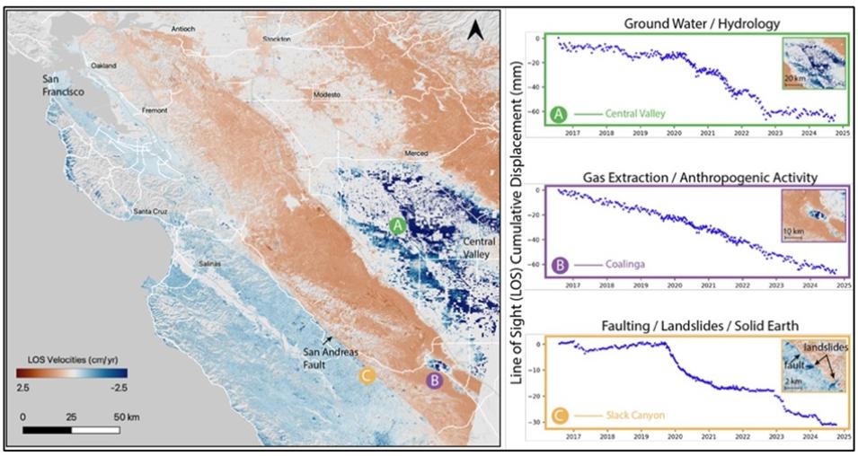
The OPERA project currently offers the DISP Sentinel-1 (DISP-S1) product and plans to provide a NISAR DISP (DISP-NI) product in the near future. Each Sentinel-1 (S1) satellite carries a synthetic aperture radar (SAR) instrument that can map Earth’s landmasses once up to every 6 days when combined with data from the S1-A/B/C satellite constellation. DISP-S1 covers much of North America, including the United States and all its Territories, parts of Canada within 200 kilometers of the U.S. border, and all mainland countries from the southern U.S. border down to and including Panama.
OPERA creates the DISP-S1 product as soon as the satellite data input becomes available. It is then distributed as frame-based granules on a fixed grid to enable easy time series analysis. Each granule contains both data raster layers and product metadata stored in the Hierarchical Data Format version 5 (HDF5) format, with a 30-meter pixel spacing in East and North directions on a UTM coordinate system.
Until now, there were no free and accessible InSAR time-series displacement products available over North America. The OPERA Surface Displacement products fill this gap by making satellite radar data more accessible to a broad range of users, including national and state government personnel, emergency responders, urban planners and civil engineers, water resources managers, and researchers in a variety of disciplines.
“The ultimate goal is to make these sophisticated Earth observation products accessible to anyone who needs them, regardless of technical expertise, to support better decision-making about our changing planet,” said OPERA Project Scientist Dr. Steven Chan.
The OPERA project is developing the DISP-S1 Level 3 product in segments focused on three geographic areas—the southwestern U.S., the northern U.S., and the Pacific Northwest and Alaska—all of which will be completed by the end of the year. The product will be rolled out in two phases. During Phase 1, which runs from now through the end of 2025, the OPERA team will develop historical data between July 2016 and December 2024. In Phase 2, the team will create any remaining historical data and all new products as the data become available.
About OPERA
The OPERA project is managed by JPL, with partners from NASA’s Goddard Space Flight Center, the U.S. Geological Survey (USGS), the University of Maryland College Park, the University of Alaska Fairbanks, and Southern Methodist University. Every two years, the multi-agency Satellite Needs Working Group (SNWG) conducts a survey to identify gaps in the current suite of NASA datasets to meet U.S. federal agency needs. Following the 2018 and 2022 surveys, OPERA was tasked to develop products that were among the top interagency needs. These products were dynamic surface water extent, surface disturbance, surface displacement, and vertical land motion.
Data Access
All OPERA products, including the Level 3 DISP-S1 products and their intermediate Coregistered Single-look Complex products, are accessible through the Alaska Satellite Facility Distributed Active Archive Center (ASF DAAC) and the NASA Earthdata Search portal. The OPERA project website contains links to all available OPERA products as well.
Learning Resources
ASF DAAC's searchable user interface for accessing and visualizing SAR data, the ASF Displacement Portal, lets users visualize, interact with, and download OPERA DISP-S1 data.
The OPERA project also has code repositories and links to additional resources, including GitHub notebooks with examples of applications using OPERA data, and workshops, on its website.
