We are in the process of migrating all NASA Earth science data sites into Earthdata from now until end of 2026. Not all NASA Earth science data and resources will appear here until then. Thank you for your patience as we make this transition.
Read about the Web Unification Project
Filters

Hot, dry, and windy conditions fueled the spread of wildfires across the region in late June and early July, when Suomi NPP captured this data.
Worldview Image of the Week
July 2, 2026

OPERA's dynamic surface water extent layer and Landsat images show extremely low water levels in this Arizona reservoir in June 2026.
Worldview Image of the Week
June 29, 2026

NASA's Fire Information for Resource Management System now provides swath outlines, showing the extent of Earth's surface within view of a sensor.
Blog
June 25, 2026

USGS researchers found NASA’s imaging spectroscopy satellite data could significantly improve identification of vegetation types across rangelands.
News
June 25, 2026

The VIIRS instrument aboard NOAA-20 captured these images of fires near the Yenisei River.
Worldview Image of the Week
June 17, 2026

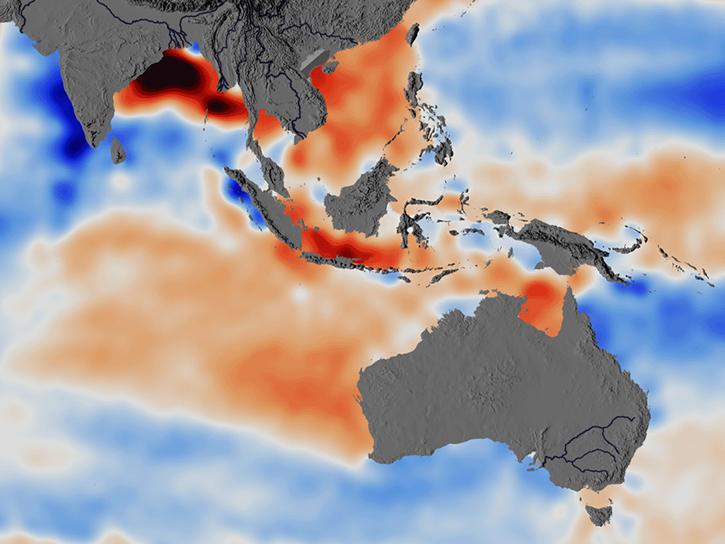
Major ocean current systems are revealed by these sea surface temperature images from June 10, 2026.
Worldview Image of the Week
June 12, 2026
Researchers used ECCO data to understand the mechanisms behind changes in salinity of the Southeast Indian Ocean.
Data in Action
June 5, 2026

The first named storm of the hurricane season appears in this nighttime image from June 3, 2026.
Worldview Image of the Week
June 5, 2026
SHOWING 8 OF 2383