Open Meetings and Workshops

The Stakeholder Engagement Program (SEP) intends to host workshops for SNWG products to demonstrate how to access and use them in a variety of use cases. Please check back here for more information regarding upcoming workshops and other content.

Catalog of Archived Suborbital Earth Science (CASEI)

CASEI Meetings and Workshops

You Might Also Be Interested In

NASA Earth Science Data Systems (ESDS) Program

During the NASA Airborne and Field Data Workshop, data users and data producers worked together to theorize ways to improve the usability of NASA airborne and related field data. CASEI, an SNWG solution cataloging detailed information about airborne and field investigations, was highlighted during the workshop. For more information, please view the NASA Airborne and Field Data Workshop (2022) Workshop Report and Recommendations.

ESDIS Communications Team

Since 2019, NASA's Airborne Data Management Group (ADMG) within the Interagency Implementation and Advanced Concepts Team (IMPACT) has worked to promote and improve the discoverability and accessibility of the agency's suborbital Earth Science observations. A primary component of this effort is the development of NASA's Catalog of Archived Suborbital Earth Science Investigations (CASEI). CASEI, officially released in July 2023, provides a single entry point for users to search and browse details from more than 65% of known NASA airborne and field campaigns, and more content is added regularly. Contextual metadata are organized and highly inter-linked to allow intuitive, integrated exploration across all of NASA's data archive centers, a key feature that sets CASEI apart from other tools. Campaign science objectives, platform and instrument configurations, and more are included in CASEI's database, facilitating multi-parameter search, browse, and discovery of relevant data products via DOI links. This presentation demonstrates the web interface experience, details CASEI's development leading up to release, and summarizes the intensive metadata curation process. To register, please visit https://www.earthdata.nasa.gov/learn/webinars-and-tutorials/webinar-casei-2023-08-30.

NASA's Airborne and Field Data Working Group

NASA's Second Airborne and Field Data Workshop will be a virtual event aimed at gathering updated information from NASA's airborne and field data provider and data user communities to improve the discoverability, access, and use of these observations. The inaugural workshop, held in 2022, touched broadly on successes and areas of opportunity. This year, we will discuss recent activities in response to 2022's main findings and next steps with a focus on tools, standards, and alignment with agency goals. To register, please visit https://www.earthdata.nasa.gov/learn/webinars-and-tutorials/second-airborne-field-data-workshop.

Commercial Smallsat Data Acquisition (CSDA) Program

CSDA Meetings and Workshops

You Might Also Be Interested In

This Lunch and Learn introduced Planet's 8-band data while providing an overview of Planet's constellations and how to access Planet data.

During this Lunch and Learn webinar, subject matter experts assess the quality of data products purchased by CSDA.

For additional meetings and workshops not found here, refer to Commercial Smallsat Data Acquisition Program Activities.

Harmonized Landsat Sentinel-2 (HLS)

HLS Meetings and Workshops

You Might Also Be Interested In

During this webinar, the HLS data production and science teams presented the product's technical details, availability and status, and its benefit to the Earth science community.

This webinar provides an overview of the Harmonized Landsat Sentinel-2 (HLS) data, services, and tools. It also provides information on how to access and visualize the data.

American Geophysical Union (AGU)

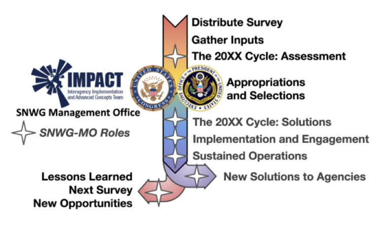
The Satellite Needs Working Group (SNWG) is a US Government inter-agency organizational body that was established in 2016 to identify the Earth observational gaps and data needs across the US Federal Civilian Agencies. The SNWG effort is a 2-year process in which NASA identifies and ultimately implements a wide range of innovative solutions that benefit the entire Earth Science community. There are currently 19 different SNWG activities underway, with many of the products now operational. In this session, we will invite representatives from the implementation teams behind several of the highly successful SNWG products to describe the new capabilities and where to access the data. This includes the Harmonized Landsat/Sentinel-2 (HLS), which is a cloud optimized dataset that standardizes common data bands from the two satellite constellations thereby effectively doubling the data available to the community. Another SNWG activity is the generation of a global surface water extent product that combines the data frequency of the optical satellites and the cloud-penetrating capabilities of satellite radar for a uniformed and frequent surface water product. Other activities include new radiation and clouds products, global air quality, land surface disturbance, North America deformation, vegetation indices suite with HLS, and planetary boundary layer products.

Ice, Cloud & Land Elevation Satellite-2 (ICESat-2) Quick Look Products

ICESat-2 Meetings and Workshops

Observation Products for End-Users for Remote Sensing Analysis (OPERA)

OPERA Meetings and Workshops

You Might Also Be Interested In

Observational Products for End-Users from Remote Sensing Analysis

During this workshop, OPERA introduced the near-global surface water (DSWx) and surface disturbance (DIST) products to gather feedback from the user community.

Observational Products for End-Users from Remote Sensing Analysis

In this workshop, OPERA presented preliminary validation results for the surface water (DSWx) and surface disturbance (DIST) products while also providing information on how to access them.

Observational Products for End-Users from Remote Sensing Analysis

In this workshop, the OPERA team provided an update on the Dynamic Surface Water Extent and Surface Disturbance products. They also introduced provisional RTC and CSLC products. 

The Satellite Needs Working Group (SNWG) is a US Government inter-agency organizational body that was established in 2016 to identify the Earth observational gaps and data needs across the US Federal Civilian Agencies. The SNWG effort is a 2-year process in which NASA identifies and ultimately implements a wide range of innovative solutions that benefit the entire Earth Science community. There are currently 19 different SNWG activities underway, with many of the products now operational. In this session, we will invite representatives from the implementation teams behind several of the highly successful SNWG products to describe the new capabilities and where to access the data. This includes the Harmonized Landsat/Sentinel-2 (HLS), which is a cloud optimized dataset that standardizes common data bands from the two satellite constellations thereby effectively doubling the data available to the community. Another SNWG activity is the generation of a global surface water extent product that combines the data frequency of the optical satellites and the cloud-penetrating capabilities of satellite radar for a uniformed and frequent surface water product. Other activities include new radiation and clouds products, global air quality, land surface disturbance, North America deformation, vegetation indices suite with HLS, and planetary boundary layer products.

Observational Products for End-Users from Remote Sensing Analysis

The fourth OPERA workshop provides updates of OPERA data products in production, preliminary validation of data products that are near-production, and an overview of upcoming 2025 products. End users will have an opportunity to present their use (or planned use) of OPERA products.

Air Quality

Air Quality Meetings and Workshops

You Might Also Be Interested In

PGN (Primarily NASA and ESA)

The first workshop for the Pandonia Global Network (PGN) that covered PGN operation, algorithms, quality assessment, data processing, calibration, stations, data policy, and other topics.

HLS-VI

HLS-VI Meetings and Workshops

You Might Also Be Interested In

NASA Applied Remote Sensing Training (ARSET)

This training will provide an overview of spectral indices for land and aquatic applications. Specifically, this training will begin with an introduction to the Normalized Difference Vegetation Index (NDVI), along with its calculation, uses, and prominence in Earth science. In session two, ARSET will expand to other spectral indices primarily used in aquatic ecosystems, such as the Normalized Difference Chlorophyll Index (NDCI), Normalized Difference Aquatic Vegetation Index (NDAVI), Floating Algal Index (FAI), and Normalized Difference Turbidity Index (NDTI) for aquatic applications. In the final session ARSET will review additional land-based indices such as the Enhanced Vegetation Index (EVI), Soil-Adjusted Vegetation Index (SAVI), and Normalized Burn Ratio (NBR). Not only will these sessions discuss the correct circumstances under which to use these indices, but participants will also take part in hands-on indices calculation over relevant study areas. Learners will work with data from Landsat 9 OLI-2, Sentinel-2 MSI and Harmonized Landsat Sentinel-2 (HLS) for indices calculation. The training will also discuss pre-calculated index products such as Terra MODIS vegetation indices and HLS vegetation indices suite and upcoming data products available based on user feedback provided to the Satellite Needs Working Group. Use cases from recent Earth Action projects (such as NASA DEVELOP) will further highlight how spectral indices can provide essential information about land and aquatic environments.

TEMPO

TEMPO Meetings and Workshops

You Might Also Be Interested In

The Satellite Needs Working Group (SNWG) is a US Government inter-agency organizational body that was established in 2016 to identify the Earth observational gaps and data needs across the US Federal Civilian Agencies. The SNWG effort is a 2-year process in which NASA identifies and ultimately implements a wide range of innovative solutions that benefit the entire Earth Science community. There are currently 19 different SNWG activities underway, with many of the products now operational. In this session, we will invite representatives from the implementation teams behind several of the highly successful SNWG products to describe the new capabilities and where to access the data. This includes the Harmonized Landsat/Sentinel-2 (HLS), which is a cloud optimized dataset that standardizes common data bands from the two satellite constellations thereby effectively doubling the data available to the community. Another SNWG activity is the generation of a global surface water extent product that combines the data frequency of the optical satellites and the cloud-penetrating capabilities of satellite radar for a uniformed and frequent surface water product. Other activities include new radiation and clouds products, global air quality, land surface disturbance, North America deformation, vegetation indices suite with HLS, and planetary boundary layer products.

PBL

PBL Meetings and Workshops

Last Updated