Contributions of NASA’s AIRS Instrument Continue with CrIS, ATMS

Next-generation instruments aboard Joint Polar Satellite System spacecraft provide continuity to the AIRS project that began in 2002.
author-share
Image
This image from the AIRS instrument shows surface air temperature over North America and the Arctic on December 22nd, 2022. As seen here, a polar vortex brought extremely cold air (shown in purple and blue) plunging into the US Central Midwest.
This image from the AIRS instrument shows surface air temperature over North America and the Arctic on December 22, 2022. A polar vortex brought extremely cold air (shown in purple and blue) plunging into the U.S. Central Midwest. Credit: Tao Wang, NASA/JPL-Caltech. Note: To see an animation of these data, visit the AIRS website.

In January 2022, NASA announced that, due to a limited remaining fuel supply, the Aqua satellite—the second flagship satellite of the agency’s Earth Observing System (EOS)—lowered its orbit to leave the A-Train. The A-Train is an international constellation of satellites that follow one another along the same orbital track and cross the equator at about 1:30 p.m., Mean Local Time (MLT). This means Aqua left its tightly controlled orbit and entered a free-drift mode in which its equatorial crossing time slowly gets later and later into the afternoon. By February 2023, the satellite was expected to reach, and possibly exceed, an equatorial crossing time of 1:45 p.m., MLT.

As it drifts, the instruments aboard Aqua will continue to transmit valuable data until losses of power and fuel bring an end to the mission. NASA officials estimate termination will occur in mid-to-late 2026, and when it happens those who rely on data from Aqua’s Atmospheric Infrared Sounder (AIRS) instrument will have to begin using data from its instrument follow-ons: the Cross-track Infrared Sounder (CrIS) and Advanced Technology Microwave Sounder (ATMS) aboard NASA/NOAA Joint Polar Satellite System (JPSS) satellites, the successors of the EOS missions.

Launched on May 4, 2002, along with the other instruments aboard Aqua, AIRS was designed to improve weather forecasting by providing more frequent and detailed information about the atmosphere.

AIRS probes a column of air 90 times every 2.67 seconds, or about 2.9 million times a day, from the top of the atmosphere to Earth’s surface, collecting measurements of humidity, temperature, cloud properties, and greenhouse gases with its 2,378 infrared spectral channels and 4 visible/near-infrared channels.

This wide array of channels, each associated with particular atmospheric properties or combinations of properties, and with particular heights or levels in the atmosphere, produced data that meteorologists could use to greatly improve the accuracy and vertical resolution of atmospheric profiles. The result of these improved soundings has been more reliable climate prediction and improved weather forecasts.

“AIRS revolutionized weather prediction by providing, for the first time, a three-dimensional picture of the atmosphere,” said Dr. Joao Teixeira, AIRS Science Team Leader, in an article commemorating Aqua’s 20th year in orbit. “Now there are a few infrared sounders in orbit, but AIRS still is one of the key sensors and, for the first few years, it was the only one.”

The more than two decades AIRS has been in orbit is remarkable, both in terms of its stability and for the contributions its 20-plus years of atmospheric data have made to the remote sensing and Earth science communities.
Image
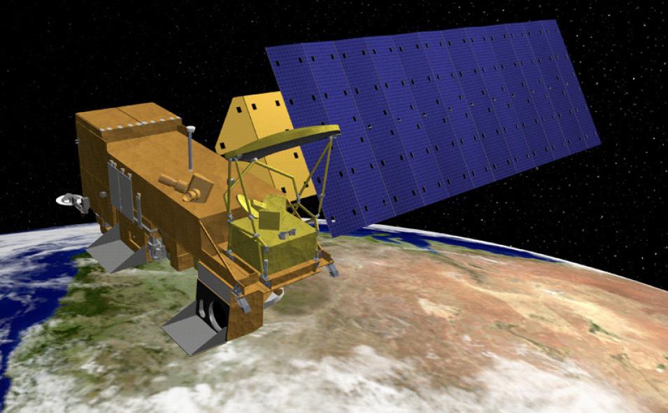
An artist's rendering of the Aqua satellite, one of the flagship satellites in NASA's Earth Observing System
An artist's rendering of the Aqua satellite, one of the flagship satellites in NASA's Earth Observing System. Credit: NASA.

“It’s been fantastic to be able to have globally, consistent information—atmospheric profiles of water and temperature and trace gasses—from an instrument that observes everything at the same time,” said Lena Iredell, Data Curation Lead at NASA’s Goddard Earth Sciences Data Information Services Center (GES DISC). “It is really quite unique for people who are using algorithms that require all of these inputs to get a result. It’s one of the few instruments out there that just gives so much information and does it at the exact same observing time every day.”

Part of what made AIRS so significant for the weather community is its ability to provide high-resolution observations of both temperature and water vapor.

“Temperature is a very fundamental variable in atmospheric physics and for climate,” said Teixeira. “Water vapor also plays a very large role, partly because it is responsible for clouds, which are condensed water vapor in the atmosphere, and water vapor essentially controls how many clouds there are and how much precipitation there is. Water vapor also interacts with the radiation emitted by the planet, and that’s why we can detect it with this instrument. It also plays a role in how much the atmosphere is mixing vertically and the processes that promote it.”

AIRS, an infrared instrument, cannot “see” through clouds, so it was designed to work in conjunction with the microwave sensors aboard Aqua—the Advanced Microwave Sounding Unit (AMSU) and the Humidity Sounder for Brazil (HSB). AMSU is particularly useful for obtaining temperature profiles in the atmosphere. HSB was designed to measure the amount of water vapor in the atmosphere, but it suffered a catastrophic failure in early 2003. Since then, AIRS and AMSU have continued to provide atmospheric temperature and water vapor measurements that are much more accurate than previous space-based measurements.

CrIS, the first of the JPSS follow-on instruments, is an advanced spectrometer with 1,305 infrared spectral channels designed to provide high vertical resolution information on the atmosphere's three-dimensional structure of temperature and water vapor. ATMS observes Earth in the microwave portion of the electromagnetic spectrum, which allows it to see through clouds to provide information about the physical properties of our atmosphere, such as temperature and moisture, which heavily influence weather patterns. CrIS and ATMS are designed to work in concert to produce global high-resolution and three-dimensional atmospheric temperature, pressure, and moisture profiles from space.

Image
An artist’s depiction of JPSS’s NOAA-20 satellite showing the location of its instruments, including the Cross Track Infrared Sounder and the Advanced Technology Microwave Sounder.
An artist’s depiction of the JPSS NOAA-20 satellite showing the location of its instruments, including the Cross Track Infrared Sounder (CrIS) and the Advanced Technology Microwave Sounder (ATMS). Credit: NASA.

Pairs of the instruments are carried on the first three JPSS satellites currently in space: the joint NASA-NOAA Suomi Polar-orbiting Partnership (Suomi NPP), NOAA-20, and the recently launched JPSS-2. Suomi NPP launched in 2011 and NOAA-20 launched in 2017, so the CrIS and ATMS instruments they carry have been operational for years. Functionally, CrIS and ATMS are quite comparable to AIRS, AMSU, and HSB.

“It’s kind of like what’s better, a Toyota or a Chevrolet? They’re both cars and they both get you where you need to go,” said Dr. Eric Fetzer, Project Scientist for the AIRS project at NASA’s Jet Propulsion Laboratory (JPL). “There are a lot of details that are different, we can have long discussions about how the spectrometric instrumentation is fundamentally different—AIRS is a grating spectrometer, CrIS is an interferometer, so the measurements are obtained in a different way, but you basically have the same information and they’re not radically different.”

Teixeira agrees.

“For the majority of the products that we produce right now, from the purest scientific ones to the more applied ones, I don’t think the users will necessarily see an enormous difference, provided NASA continues to support this work,” he said. “So, if people use temperature or water vapor profiles or if they use ground surface temperature from AIRS to study drought, they will be able to continue to do so with CrIS. These products will continue to exist.”

According to Lena Iredell, the reason there isn’t much difference among the products is that the same scientists are involved in generating data products for both the infrared and microwave instruments. Dr. Bjorn Lambrigtsen at JPL is doing all of the microwave instrumentation for AIRS and ATMS, and Dr. Hank Revercomb at The University of Wisconsin and Dr. Larrabee Strow of the University of Maryland Baltimore County are doing all of the infrared instrumentation for AIRS and CrIS. As Iredell notes, this makes the Level 1B and C products “very consistent."

Further, work by Strow and his colleagues has resulted in new products designed to facilitate the transition from AIRS to CrIS.

Image
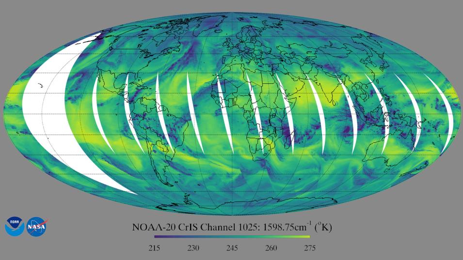
This first light image from the CrIS instrument aboard NOAA-20 shows the global brightness temperature distribution at daytime in one of the CrIS water vapor channels. Dark blue colors in the image represent liquid water and ice clouds. Yellows indicate that the radiation is from the warm Earth's surface, or a dry layer in the middle troposphere.
This first light image from the CrIS instrument aboard NOAA-20 shows the global brightness temperature distribution at daytime in one of the CrIS water vapor channels. Dark blue colors in the image represent liquid water and ice clouds. Yellows indicate that the radiation is from the warm Earth's surface or a dry layer in the middle troposphere. Credit: STAR CrIS SDR Team.

“Beyond the Level 1B algorithm, Strow also has what he calls a Level 1C algorithm, which smooths things out and fills things in,” Iredell said. “He has gone even further and made what he calls a Level 1D product, which does a similar thing across all the instrumentation—from AIRS to CrIS and [from] CrIS to CrIS—so that people can use these data as inputs to their forecast models or for reanalysis.”

There is similar continuity among the more processed data products, said Teixeira.

“What matters to most people are what we call the Level 2 and Level 3 data products, products like the temperature profiles, water vapor, carbon dioxide, clouds, methane, aerosols, and so on,” he said.  “What the community has been trying to do, be it through [NASA] Headquarters projects, the AIRS project, or other smaller entities, is develop algorithms that are unified in the sense that they can extract information both from the AIRS and CrIS radiances to create similar products from both instruments.”

One of those algorithms—the Community Long-term Infrared Microwave Coupled Atmosphere Product System (CLIMCAPS) algorithm—produces products from both AIRS and CrIS radiances in a way that is similar to the AIRS algorithm developed by the AIRS science team.

“With CLIMCAPS you use the same piece of code with very small changes between the two,” Teixeira said. “This is the type of effort being funded by NASA, and a lot of this has been done with the help of the AIRS project.”

It is possible that those “small changes” could impact data users, depending on their geographical areas of interest and the research they conduct.

“There are some subtle differences in the algorithms that have to do with how they compute the initial guess. So, if someone focused on a particular area or feature, such as ice and snow over Greenland and the Poles or desert regions, there might be subtle differences between the AIRS science team algorithm and the CLIMCAPS algorithm,” said Iredell.  “But in the majority of cases, the differences are very minor; the algorithms are very consistent among each other. Switching from the one to the other, and especially if they use the AIRS data from the CLIMCAPS system throughout, it’s very consistent across satellites and across the algorithms.”

To address such challenges, Fetzer suggests that users take the time to familiarize themselves with the products based on these new algorithms. At the same time, he noted that the sounder community will need to “show as much consistency between the new products and the old” as it possibly can.

“Having different instruments on different spacecraft [means] you’re looking at a slightly different atmosphere and there are issues [associated with] the instruments being at different orbital heights, even though they’re in the same base local time, or they were until Aqua started to drift,” Fetzer said. “So, they’re not looking at exactly the same thing at exactly the same time. That needs to be well understood if we’re trying to put together a long-term data record of retrieved quantities.”

That reconciliation is happening, said Teixeira, but it takes time.

“The algorithms that we have to develop for instruments like AIRS or CrIS are extremely complicated, so it has likely taken longer for the CrIS algorithms to come to fruition. AIRS has 2,378 infrared channels and 4 visible/near-infrared channels, so there’s a lot of information in those and extracting the right information is an enormous challenge,” he said. “We have unified algorithms that extract radiances from both AIRS and CrIS to produce all these different geophysical products that look fairly similar. The radiances come from different instruments, but if you look at the climatologies, they don’t really look much different. This is a reassurance that, indeed, these products are doing what they’re supposed to do.”

And the expectation is that the next-generation instruments aboard the JPSS spacecraft will continue providing this service until the 2040s.

Image
A screen capture of the AIRS mission website showing the dialog box data users can use to ask questions of the AIRS science team.
Data users can get answers to their questions by contacting the AIRS project via the “Ask AIRS” box of the AIRS project website. Users can also direct their questions to NASA’s GES DISC via the “contact us” page on the DAAC’s website.

“In a sense we’re blessed,” said Fetzer. “I look at other instruments on EOS and most of them don’t have the same degree of continuity. But for us, you turn around and there’s a new hyperspectral infrared sounder being launched and others are being proposed. So, from the climate perspective, I think the view is, I have really good measurements starting in 2002 with AIRS and continuing into the 2030s and even the 2040s with follow-on instruments.”

Nevertheless, Fetzer acknowledges that putting together a consistent picture of the atmosphere from these many different sounding instruments in different orbits from different spacecraft presents a unique challenge.

“In a sense, there’s almost too much here,” he said. “It’s like having too much money. What would you do if someone gave you a billion dollars? There is some good to be done with it, but the challenge is really making sense of all these different datasets in a consistent way.”

Data users can help address that challenge, said Fetzer, by sharing their research-oriented questions.

“Hypothetically, what if someone wants to look at some quantity observed by AIRS starting in 2002 and they want to look at that same quantity with CrIS instruments until 2032? There’s a good chance they’ll be able to do that,” he said. “Similarly, what happens when you transition from AIRS to one CrIS to another? What happens when you transition from one CrIS instrument to another? New and better is good, but slightly different throws you a curve ball.”

Users looking for answers to these and other data continuity questions should direct their queries to NASA's GES DISC via the contact us link on the DAAC’s website or to the AIRS project via the Ask AIRS dialog box on the AIRS website.

“If people need to know something, they can pose their questions directly to the AIRS project and we’ll answer,” Teixeira said. “That is probably the best place to start.”

Teixeira is quick to add, however, that the AIRS project isn’t going away tomorrow.

“The hope is that we will have AIRS data for the next three years, and the expectation from the Aqua mission is that we will have enough power to exist until the end of 2026,” he said. “Whether we’ll have enough funding to continue the AIRS project is something that has yet to be decided, but I’m hopeful that’s the case.”

Last Updated