NOAA-20 CERES Instrument Now Primary Source for Observing Heat Budget

The planned retirement of Terra and Aqua will have minimal impact on the continuity of the CERES long-term climate data record.
author-share
Image
Earth's energy balance refers to the amount of energy received from the Sun (yellow arrows) minus the energy reflected and emitted from Earth (red arrows). Clouds play an important role in regulating this balance. Thin cirrus clouds permit sunlight to pass through them, while blocking a significant amount of the heat radiating from the surface. Thick cumulus clouds reflect the most sunlight and block the majority of heat radiating from the surface. Credit: NASA.

Earth's climate is determined by a delicate balance between how much of the Sun's radiative energy is absorbed in the atmosphere and at the surface, and how much thermal infrared radiation is emitted to space. In 2005, NASA scientists concluded that Earth's energy balance is positive, meaning the planetary system is gaining energy, causing it to heat up, and last year (2021), a joint NASA-NOAA study found that Earth's energy balance doubled during the 14-year period from 2005 to 2019. These findings are significant, as this increasing warmth is driving other climatological and environmental changes.

To arrive at these conclusions, scientists relied on data from in-situ measurements and satellite instruments. Among the most critical were data from the six Clouds and the Earth's Radiant Energy System (CERES) instruments in orbit aboard NASA's Terra and Aqua satellites (Terra and Aqua both carry two CERES instruments), the joint NASA-NOAA Suomi National Polar-orbiting Partnership (Suomi NPP) satellite, and the Joint Polar Satellite System's (JPSS) NOAA-20 (formerly JPSS-1) satellite.

As these satellites orbit Earth, the CERES instruments they carry measure the energy radiated and reflected at the top of Earth's atmosphere. According to CERES Science Team Principal Investigator Dr. Norman Loeb, obtaining these basic measurements of the amount of energy coming in and going out of the planet is critical to understanding both Earth's climate and climate change.

"From these measurements, we are able to assess the heat budget of the planet, meaning how much energy is absorbed and how much is emitted," he said. "This is important because, over time, if more energy is absorbed than emitted, Earth will heat up, more ice and snow will melt over land, which will eventually find its way to the ocean and raise sea level, and heat the ocean, which will also cause sea level rise."

Loeb and his fellow CERES science team members also use CERES observations in combination with data from other satellite instruments—namely Terra and Aqua's Moderate Resolution Imaging Spectroradiometer (MODIS) instruments and Aqua's Atmospheric Infrared Sounder (AIRS) instrument—to calculate the radiated and reflected energy within the atmosphere and at the surface. These datasets are then used to enhance scientists' understanding of how energy flows within the climate system.
Image
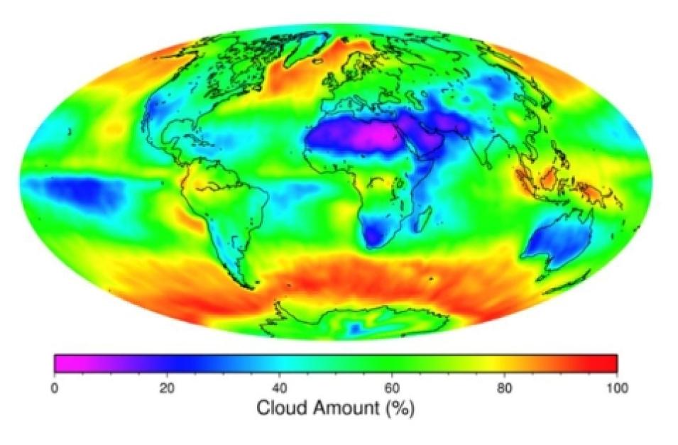
One of the greatest challenges in predicting how much Earth will warm in response to a doubling of atmospheric CO2 involves the representation of clouds and their interactions with the Earth Radiation Budget (ERB) in climate models. The CERES Science Team has merged CERES and auxiliary data to develop data products that meet this challenge by providing a comprehensive suite of variables that describe clouds and their influence on ERB. Credit: NASA CERES Project.

"We use MODIS quite a bit, which enables us to look at properties in the atmosphere and at the surface that are driving the changes in radiation at the top of the atmosphere. So, we use the two synergistically, to provide more information than one alone can provide," said Loeb. "We make use of AIRS as well to help us constrain the upper tropospheric humidity, which we need to make calculations of the surface radiative fluxes. AIRS provides us with a way of making those calculations more accurate."

Having four CERES instruments in orbit for more than 20 years aboard Terra and Aqua has helped Loeb and his colleagues learn a great deal about the changes occurring in Earth's energy balance.

"We've learned that there's more energy coming in than going out and that this imbalance has actually doubled over the Aqua period," Loeb said. "It's a truly incredible thought given the implications I mentioned earlier. We wouldn't have learned this had the missions lasted only for six years."

Having been in orbit for more than two decades, both Terra and Aqua continue to perform far beyond expectation. However, NASA announced in February 2020 and March 2021 that Terra and Aqua have had their final orbit maneuvers allowing them to maintain their morning and afternoon orbits and will be retired in the coming years due to fuel limitations. When that occurs, the satellites and the instruments they carry will be turned off, ending the data streams they and their instruments have provided for the past 20-plus years.

Fortunately, the CERES instruments in orbit aboard Suomi NPP and NOAA-20 will provide the data necessary to continue the long-term climate data record that began with the CERES instruments aboard Terra.

"If people are analyzing the 20-plus years of CERES data, right now they're using Terra and Aqua. The record starts with [CERES data from] Terra, and then goes to Terra plus Aqua," said Loeb. "The plan was to transition to NOAA-20 and we were going to do that in July [2020], but with the Aqua anomaly that we had in April [2020], we figured we'd just do it then. So, NOAA-20 has taken over from Terra and Aqua, so the [climate data] record will be Terra only from March 2000 to June 2002, Terra and Aqua from July 2002 to March 2022, and then NOAA-20 from April 22 onward."

Loeb added, however, that other CERES data products will continue with data from Terra and Aqua. Only one monthly product used for monitoring long-term variability and other parameters has stopped using Terra and Aqua data due to changes in the satellites' mean local (or equatorial crossing) times.

"We came up with a strategy for generating a seamless climate data record from Terra, Terra and Aqua, and now NOAA-20," Loeb said.

Image
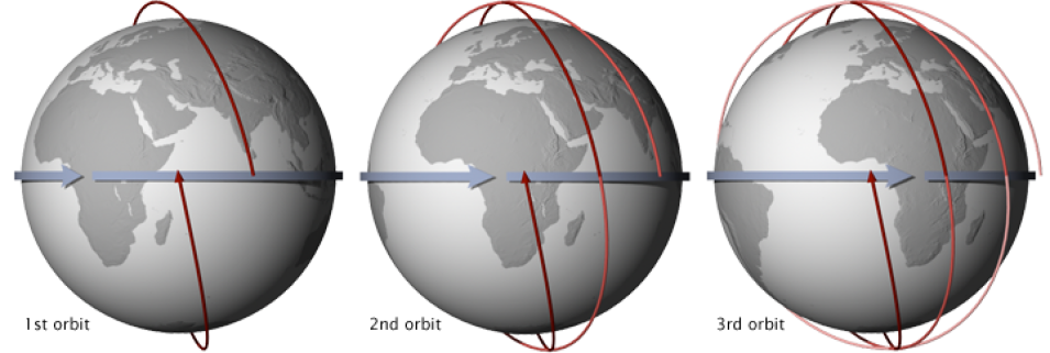
The Aqua, Terra, Suomi NPP, and NOAA-20 satellites travel in a Sun-synchronous orbit that has them crossing the equator at approximately the same local time each day (and night). This orbit allows consistent scientific observations with the angle between the Sun and Earth's surface remaining relatively constant. These illustrations show three consecutive orbits of a Sun-synchronous satellite with an equatorial crossing time of 1:30 p.m., Mean Local Time (MLT). The satellite’s most recent orbit is indicated by the dark red line, while older orbits are lighter red. Credit: NASA illustration by Robert Simmon.

To continue the data products for assessing the atmospheric properties and surface characteristics with the potential to impact Earth's energy balance, Loeb and his colleagues are using data from Suomi NPP's and NOAA-20's Visible Infrared Imaging Radiometer Suite (VIIRS) and Cross-track Infrared Sounder (CrIS) in place of MODIS and AIRS, when possible.

“VIIRS is essentially used for cloud retrievals, so yes, VIIRS is kind of being used like MODIS,” Loeb said. "And then we're using CrIS. The CrIS water vapor channel is useful, as VIIRS doesn't have one like MODIS does, so we're supplementing VIIRS with CrIS. There's a group at the University of Wisconsin that's producing a fusion product—a fusion of VIIRS and CrIS—for us. We're using CrIS in other ways, as well.”

Image
Libera is a follow-on to the Clouds and the CERES instruments that flew on Suomi NPP and NOAA-20. It will help maintain the 40-year data record of the solar radiation balance. Credit: JPSS.

Although it will be fortunate to have a pair of CERES instruments already in orbit when Terra and Aqua are retired, Loeb has expressed some concern about going to from six instruments in orbit to two, as it increases the risk of a data gap.

"We did a gap probability analysis and if you project to late 2027 or early 2028, when the Libera instrument (the CERES follow-on) is supposed to be launched into space aboard the JPSS-3 satellite, there's a 38% chance of a data gap, and that's concerning because the existing CERES instruments are going to drop out," he said. "Ideally, Libera will be flying at the same time as NOAA-20, so hopefully we'll have a good period of overlap. But at some point, only a single instrument will be flying, so a gap is a concern."

"Terra and Aqua were a nice combination because they're in a sweet spot in the diurnal cycle. Their mean local times were such that if you took those two times and averaged them, the average was close to what a full diurnal average would be," Loeb said. "If you take away the morning, then the correction for the diurnal cycle is much larger. It's unfortunate, but there isn't much we can do about it."

Therefore, Loeb and his CERES Science Team colleagues are implementing their plan to continue the CERES climate data record with data from NOAA-20's instrument, which includes the interim release—version 4.2—of the CERES climate data record product known as the Energy Balanced and Filled (EBAF) product this fall.

"We're releasing version 4.2 this fall, and there's a number of reasons why. One is the mean local-time drift," Loeb said. "We did some studies to see how long a change in mean local time impacts the climate data record, and we decided when we're going to do the switch [to NOAA-20] based on the results of that study. So, the mean local time change is the main reason for releasing this updated version, but there are other reasons too."

Loeb and his CERES colleagues are also planning a major reprocessing of all CERES products in the near future.

"That is a few years away, but we’re working on the improvements now," he said.

As these plans suggest, the effort to extend the CERES data record with next generation instruments is well underway. As it continues, and as scientists find new ways to take advantage of the capabilities offered by the next generation of instruments aboard the JPSS satellites, CERES' contributions to the scientific community's understanding of Earth's radiation budget and how energy flows within the climate system will continue.

Note: CERES data are available through NASA's Atmospheric Science Data Center (ASDC), which archives and distributes NASA Earth Observing System Data and Information System (EOSDIS) data related to Earth's radiation budget, clouds, aerosols, and tropospheric composition.

Last Updated