NASA Earth Science Dataset Roundup
The Japan Aerospace Exploration Agency (JAXA) is offering Advanced Land Observing Satellite-2 (ALOS-2) Phased Array L-band Synthetic Aperture Radar (PALSAR) ScanSAR Level 1.1 Single Look Complex (SLC), full-aperture focusing data products acquired over the area of the recent earthquakes in Turkey and Syria. Level 2.2 ScanSAR products also are available to download.
These free ScanSAR products are provided as Normalized Radar Backscatter (NRB), formatted in full compliance with the Committee on Earth Observation Satellites (CEOS) threshold specifications for Analysis Ready Data (CEOS-ARD NRB). The CEOS ARD format aims to reduce the data processing load for users unfamiliar with satellite data and to improve data machine-readability and analysis-readiness.
JAXA is providing these data through their G-Portal search and download application, Google Earth Engine, and the Amazon Web Services (AWS) Open Repository via direct Amazon Simple Storage Service (S3) bucket access.
ALOS series data access and more information.
Atmospheric Science Data Center (ASDC)
CALIPSO Night Validation Flight Data
NASA's ASDC has released Cloud-Aerosol Lidar and Infrared Pathfinder Satellite Observations (CALIPSO) Night Validation Flights (NVF) data for an airborne deployment conducted in Bermuda in August 2022. The goal of CALIPSO-NVF was to conduct a series of nighttime flights along the track of the CALIPSO satellite (underflights) with the NASA Langley High Spectral Resolution Lidar (HSRL-2). The western Atlantic Ocean was selected for CALIPSO-NVF to allow unobstructed, 45-minute flights along the satellite ground track. Five nighttime underflights were executed, four of which were conducted in cloud-free conditions on August 7, 10, 12, and 17, yielding ideal data for calibration and validation. Total research flight time was 17.7 hours, sampling 2,200 km along the CALIPSO ground track.
CALIPSO data access and more information.
New CERES Energy Balanced and Filled Data Product
The Radiation Budget Science Project (RBSP) and Clouds and the Earth's Radiant Energy System (CERES) Science Team released Edition 4.2 of the CERES Energy Balanced and Filled (EBAF) data product. EBAF 4.2 seamlessly combines CERES observations from NASA’s Terra and Aqua satellites (Terra from March 2000 to June 2002 and Terra and Aqua from July 2002 to March 2022) and the joint NASA/NOAA NOAA-20 satellite (from April 2022 onwards). Algorithm improvements and corrections to both Top-of-Atmosphere (TOA) and surface fluxes are included in this update.
This initial release of combined TOA and surface fluxes and cloud properties covers the period from March 2000 to March 2022. A stand-alone version of TOA fluxes and cloud properties is current through November 2022. Additional months will become available as they are processed.
CERES data access and more information.
For more information about CERES data continuity from Terra and Aqua to NOAA's Joint Polar Satellite System, see the NASA Earthdata article NOAA-20 CERES Instrument Now Primary Source for Observing Heat Budget.
Global Hydrometeorology Resource Center DAAC (GHRC DAAC)
New IMPACTS NEXTRAD Data Products
NASA’s GHRC DAAC has released five new Next Generation Weather Radar (NEXRAD) Investigation of Microphysics and Precipitation for Atlantic Coast-Threatening Snowstorms (MPACTS) datasets. These data were collected at 31 NEXRAD sites from January 1 to March 1, 2020, during the 2020 IMPACTS field campaign. The datasets contain meteorological and dual-polarization base data quantities, including radar reflectivity, radial velocity, spectrum width, differential reflectivity, differential phase, and cross correlation ratio. NEXTRAD Data access and more information.
Goddard Earth Sciences Data and Information Services Center (GES DISC)
HAQAST Annual Summary of Artificial Light At Night Data
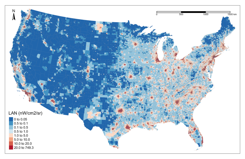
NASA’s GES DISC has released the NASA Health and Air Quality Applied Sciences Team (HAQAST) Annual Summary of Artificial Light At Night (ALAN) at CONUS County and Census Tract, Version 1 Data Product. The product is created from data acquired by the Visible Infrared Imaging Radiometer Suite (VIIRS) instrument aboard the joint NASA/NOAA Suomi National Polar-orbiting Partnership (Suomi NPP) satellite.
The VIIRS Day/Night Band (DNB) nighttime lights (NTL) product in NASA’s Black Marble suite is used to derive annual summaries of ALAN levels throughout the continental U.S. (CONUS) at both county and tract level, and covers the period 2012 to 2020. The product is an outcome of HAQAST's “Applying NASAs Earth Observation Products to Improve ALAN Mapping and Public Health Surveillance” project, which aims to integrate ALAN data in environmental health monitoring programs to better understand the public health implications of artificial nighttime lights and enable evidence-based decision-making.
HAQAST artificial light data access and more information.
HAQAST Nitrogen Dioxide Surface-Level Annual Average Concentrations
HAQAST, which is comprised of scientists at George Washington University, Oregon State University, the University of Washington, and NASA, created a global surface-level nitrogen dioxide (NO2) dataset, estimating concentrations in grid cells at a 1 km spatial resolution for 1990, 1995, 2000, and 2005 to 2020. This dataset fuses satellite-measured NO2 from NASA’s Ozone Monitoring Instrument (OMI) with a land-use regression model, which synthesizes information on population density, transportation, surface cover, and other variables. Air quality, environmental science, environmental justice, and public health researchers may benefit from these global estimates, which are particularly useful for studying long-term trends in NO2 and associated health impacts.
HAQAST surface level NO2 data access and more information.
Land Processes DAAC (LP DAAC)
New GEDI Version 2 Data
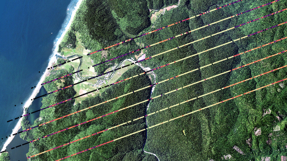
NASA’s LP DAAC has released Version 2 of three Global Ecosystem Dynamics Investigation (GEDI) datasets for October 26 through December 21, 2022:
- Level 1B Geolocated Waveform Data Global Footprint Level, which provides geolocated corrected and smoothed waveforms, geolocation parameters, and geophysical corrections for each laser shot for all eight GEDI beams
- Level 2A Elevation and Height Metrics Data Global Footprint Level, which provides waveform interpretation and extracted products from each GEDI01_B received waveform, including ground elevation, canopy top height, and relative height (RH) metrics
- Level 2B Canopy Cover and Vertical Profile Metrics Data Global Footprint Level, which provides canopy cover, Plant Area Index (PAI), Plant Area Volume Density (PAVD), and Foliage Height Diversity (FHD) metrics
Users can access these data products from the LP DAAC's Data Pool and NASA Earthdata Search.
GEDI V2 data access and more information.
Level-1 and Atmosphere Archive and Distribution System DAAC (LAADS DAAC)
LAADS DAAC Completes Phase 1 Dataset Migration to the Cloud
NASA’s LAADS DAAC completed Phase 1 of migrating datasets distributed by the DAAC to the Earthdata Cloud. These datasets include Moderate Resolution Imaging Spectroradiometer (MODIS) Geolocation, Cloud Mask, and Level-2 and Level-3 Atmosphere Products, as well as a list of LAADS DAAC’s 75 most popular data products.
The second phase, which the DAAC expects to complete later in 2023, will include the Visible Infrared Imaging Radiometer Suite (VIIRS) Level-1, Geolocation, and Atmosphere products. This will be followed by MODIS Level-2 Surface Reflectance products, Long Term Data Records derived from the Advanced Very High Resolution Radiometer (AVHRR) instrument aboard NOAA’s Polar Orbiting Environmental Satellites (POES) and the ESA (European Space Agency) Meteorological Operational satellite (MetOps), the Medium Resolution Imaging Spectrometer (MERIS) aboard the ESA Envisat mission, ESA Sentinel-3A and Sentinel-3B Level-1 products, and airborne data products.
A full list with updated information is available on the LAADS DAAC cloud migration webpage.
National Snow and Ice Data Center DAAC (NSIDC DAAC)
Updated NASA Making Earth System Data Records for Use in Research Environments (MEaSUREs) Program Greenland Image and Ice Sheet Velocity Mosaics
NASA's NSIDC DAAC has released temporal coverage updates for the MEaSUREs Greenland Image Mosaics from Sentinel-1A and -1B, Version 4 and MEaSUREs Greenland 6 and 12 day Ice Sheet Velocity Mosaics from SAR, Version 2 datasets. The temporal coverage for both the image mosaics and 6- and 12-day velocity mosaics data now spans from January 1, 2015, to January 24, 2023.
MEaSUREs Greenland Mosaics and Velocity Mosaics data access and more information.
Oak Ridge National Laboratory DAAC (ORNL DAAC)
New Arctic-Boreal Vulnerability Experiment (ABoVE) Data Available
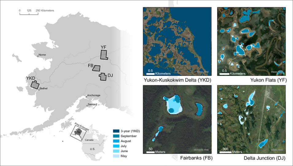
NASA’s ORNL DAAC recently released a new ABoVE dataset. This new product provides polygon spatial files of lake and pond extents for three sub-regions of Interior Alaska's boreal forest and one tundra region located in Alaska's Yukon-Kuskokwim Delta; lake and pond extents of standing water without wetland vegetation or other obstructions with a minimum area of 0.01 ha; and water extents derived from Planet Labs PlanetScope imagery with resolution of 3.125 meters. Water body data are provided as 3-year composites (2019-2021) for all four regions and as monthly climatological composites from May to September for the three boreal forest regions. The composite water files indicate the presence of open, standing water in more than 40% of valid PlanetScope satellite observations for a given composite time-slice.
Lake & Pond Extents in Alaska data access and more information.
New Carbon Monitoring System (CMS) Program Dataset for Tree Cover Estimates for Mexico
NASA's ORNL DAAC recently released a new CMS dataset that provides multi-year (2016-2018) percent tree cover (TC) estimates for Mexico at 30 m spatial resolution. The data are derived from the 30 m Landsat Collection 1 product and a hierarchical deep learning approach (U-Net) developed in a previous CMS effort for the conterminous U.S. The dataset also can be helpful for studies of carbon cycling, land cover and land use change, and similar research.
Tree Cover Estimates for Mexico data access and more information.
Physical Oceanography DAAC (PO.DAAC)
New GHRSST Sea Surface Temperature Dataset
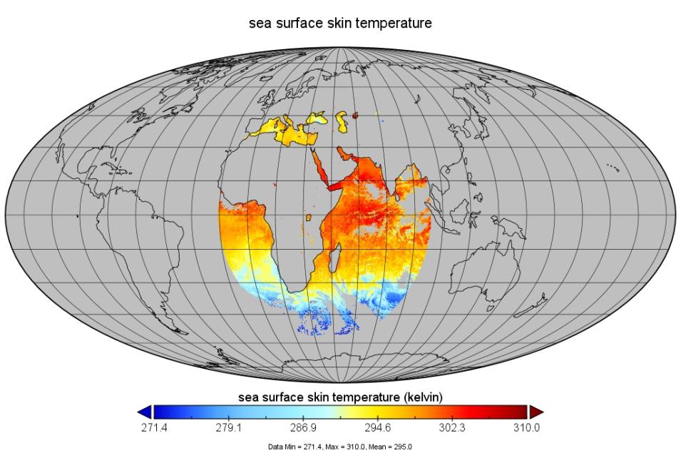
NASA's PO.DAAC has released the Group for High Resolution Sea Surface Temperature (GHRSST) Level-2P NOAA MSG01/02/04 Sea Surface Temperature (SST) v1.0 datasets. This release comprises three Level 2P SST v1.0 datasets derived from the Spinning Enhanced Visible and Infrared Imager (SEVIRI) sensor aboard the Meteosat Second Generation (MSG) satellite series (1, 2, and 4, also known as Meteosat-8, -9, and -11). The MSG Level 2P SST data product provides full disk SEVIRI imagery on the native swath grid at approximately 3 km resolution with a 15-minute duty cycle. Both MSG01 and MSG02 cover the Indian Ocean at 45.5° east longitude, while MSG04 and MSG03 cover the Atlantic Ocean at 0° east longitude. The three SST measurements provide temporal coverage from September 18, 2018, to June 1, 2022 (MSG01); June 11, 2022, to the present (MSG02; and September 10, 2018, to March 24, 2023 (MSG04).
GHRSST Sea Surface Temperature Dataset information pages.
Users are encouraged to download the data with podaac-data-subscriber.
More information about the GHRSST SST dataset.
New Optimally Interpolated Sea Surface Salinity (OISSS) 7-Day and Monthly Level-4 Datasets
The principal investigator (PI)-produced Multi-Mission OISSS 7-Day and Monthly Level-4 V2.0 datasets are based on the AQUARIUS/SAC-D, Soil Moisture Active Passive (SMAP) mission, and Soil Moisture and Ocean Salinity (SMOS) Level-2 mission 0.25-degree gridded data. An optimal interpolation is applied to each mission dataset to create a gap-free gridded product. The datasets cover the period from August 2011 through October 2022, and will be updated regularly every six months as new data are made available.
Sea Surface Salinity data access and more information.
For a complete list of new datasets, see the EOSDIS New Datasets webpage.


