ORNL DAAC Releases GEDI Level 4B Dataset Offering Gridded Estimates of Aboveground Biomass Density

The latest dataset from the GEDI mission provides gridded estimates of aboveground biomass density at greater accuracy and resolution than previously available.
author-share
Image
GEDI logo

It's well known that the trees in Earth’s forests absorb carbon dioxide (CO2) from the atmosphere and, through the process of photosynthesis, convert it to biomass — essentially storing the carbon in their roots, branches, leaves, and stems as they grow. Yet, measuring just how much carbon is stored in Earth's forests can be a challenge. For example, when forests are disturbed through natural or human causes, such as fire or deforestation, they release this stored carbon back into the atmosphere. At the same time, forests are estimated to absorb about one-third of the fossil carbon emitted per year.

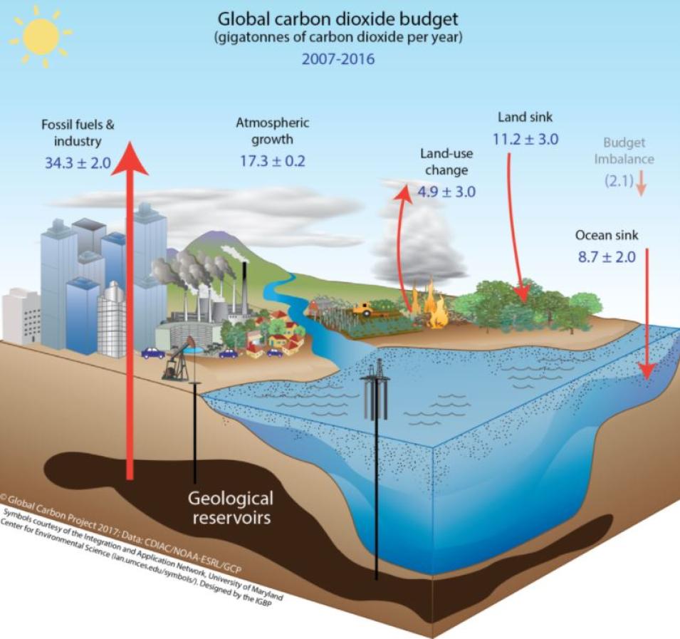
Therefore, there is great uncertainty about the magnitudes of carbon emitted and absorbed by forests. When scientists conduct a global accounting of the sources and sinks of carbon, they expect their assessment to balance, as all that carbon must go “somewhere.” What the scientific community has found, however, is an imbalance. There is some emitted carbon that cannot be accounted for. The world’s forests are thought to be this missing carbon sink.

Ecosystem models are the scientific community's best tool for answering these and other forest-related carbon sequestration questions. Yet, if the predictions from models are to be credible, the biomass data used to inform them must be as accurate as possible, as it provides the foundational information on which any assessment of carbon sequestration rests.
Image
This is an illustration depicting the global carbon budget.
This illustration shows the major elements of the global carbon cycle.

The newly released Level 4B (L4B) Gridded Aboveground Biomass Density dataset from NASA’s Global Ecosystem Dynamics Investigation (GEDI) mission provides that foundation by providing near-global estimates of aboveground biomass density (AGBD) in megagrams per hectare (Mg/ha) at a 1-kilometer (km) resolution between 51.6° North and 51.6° South latitudes.

"The GEDI Level 4B dataset offers estimates of AGBD at greater accuracy and resolution than has previously been possible and contributes to the understanding of the distribution of AGBD around the globe, especially for tropical and temperate forests," said Dr. Rupesh Shrestha, a research staff member at NASA's Oak Ridge National Laboratory Distributed Active Archive Center (ORNL DAAC).

The distribution of aboveground biomass and how it interacts with the changing climate and other disturbances is not well understood. The GEDI mission’s new Level 4B dataset will help change that by providing climate researchers, ecologists, and others with globally consistent measurements to aid estimates of carbon sequestration under a range of climate and land-use scenarios.

“One of the largest uncertainties we have is in understanding the global impact of deforestation (whether from trees being cut down, forest fires, or natural disturbance) on atmospheric CO2,” said Dr. Ralph Dubayah, Principal Investigator of the GEDI mission team at the University of Maryland. “That presents a problem because if we don’t understand that, we are not able to accurately predict how atmospheric CO2 concentrations may grow. GEDI contributes to our ability to account for land-use change and its impact on atmospheric CO2 concentrations by providing these kinds of data.”

This data is then fed into ecosystem models that enable predictions of how much carbon forests will sequester over time.

“We run a model, in this case the Ecosystem Demography Model, and we initialize it with the canopy heights we get from GEDI,” said Dubayah. “[The model] is then able to project how much carbon will be sequestered a year from now, 10 years from now, 100 years from now. Furthermore, we can ask questions such as, ‘Suppose we let forests grow on the unforested areas in Maryland that could support them. How much more carbon would we sequester?’ These kinds of modeling exercises are predicated on us knowing what the successional status is on the land surface right now.

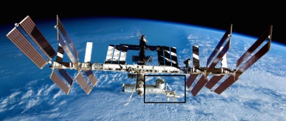
Launched on December 2018 and installed on the International Space Station's (ISS) Japanese Experiment Module-Exposed Facility, the GEDI instrument is a full waveform lidar (i.e., laser version of radar) instrument offering the highest resolution and densest sampling of any lidar ever put in orbit. Led by scientists at the University of Maryland, the mission is supported by NASA’s Goddard Space Flight Center.

Image
This is an image of the ISS with a location box around where the GEDI sensor is located.
The GEDI instrument is deployed on the Japanese Experiment Module – Exposed Facility (JEM-EF). The highlighted box shows the location of GEDI on the JEM-EF.

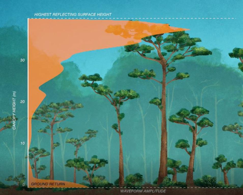
The sole GEDI observable is the lidar waveform and all the GEDI data products are derived from it. Lidar waveforms quantify the vertical distribution of vegetation by recording the amount of laser energy reflected by plant material (stems, branches, and leaves) at different heights above the ground. From these waveforms, different structure information can be extracted, such as surface topography, canopy height metrics, canopy cover metrics, and vertical structure metrics.

Upon receipt, these data are then transferred to the GEDI Mission Operations Center and processed through the Science Operations Center, both of which are located at Goddard. Then they are sent to two NASA Earth Observing System Data and Information System (EOSDISDAACs, where they are archived, managed, and distributed to a diverse user community around the globe.

The GEDI mission has published several previous datasets. The first, lower-level datasets — a Level 1B product that provides geolocated waveforms and Level 2A and 2B products providing canopy height and canopy profile metrics at the footprint level — were made available in January 2020 through NASA’s Land Processes DAAC (LP DAAC), a partnership between NASA and the U.S. Geological Survey that manages, archives, and distributes EOSDIS land processes data, services, and tools for discovering and analyzing data.

Image
Graphic of lidar waveform data acquired by GEDI
The sole GEDI observable is the lidar waveform and all the GEDI data products are derived from it. Lidar waveforms quantify the vertical distribution of vegetation by recording the amount of laser energy reflected by plant material (stems, branches, and leaves) at different heights above the ground. From these waveforms, four types of structure information can be extracted: surface topography, canopy height metrics, canopy cover metrics, and vertical structure metrics.

Along with the GEDI Level 3 and Level 4A datasets released in 2021, the GEDI Level 4B dataset is available from ORNL DAAC, a partnership between NASA and the U.S. Department of Energy that is responsible for collecting, archiving, and distributing EOSDIS data related to biogeochemical dynamics, ecological data, and environmental processes.

According to Shrestha, the GEDI Level 4B dataset complements the Level 4A Version 2 product released in December 2021 and provides a statistically derived gridded version of the footprint-level estimates from GEDI Level 4A data. With the publication of GEDI Level 4B dataset, all the GEDI science products (L1B, L2A, L2B, L3, L4A, and L4B) are now available as Version 2. Version 2 of these GEDI products offers improved footprint geolocation and other algorithmic improvements.

Along with the Level 4A footprint level estimates of AGBD, the Level 4B gridded data will undoubtedly be a boon to ecologists researching the carbon and water cycling processes of Earth’s terrestrial ecosystems, biodiversity, and habitat quality and structure. They will also be of use to environmental policymakers working at the regional, national, and international levels by enabling estimation of the carbon sequestration potential under future climate and land-use scenarios. For example, information on AGBD and its distribution are needed to meet national compliance to international treaties such as United Nations Framework Convention on Climate Change (UNFCC) and the measurement, reporting, and verification systems for the UNFCC’s Reducing Emissions from Deforestation and forest Degradation (REDD+) framework, which guides activities in the forest sector that reduce emissions from deforestation and forest degradation and promote sustainable forest management in developing countries.

“Many developed countries have National Forest Inventories (NFIs), whose goal is to estimate how much is carbon is being lost through deforestation and how much is being gained through growth and through afforestation, which they then report to the United Nations for climate treaties, carbon treaties, and the like,” said Dubayah. Other countries don’t have NFIs, so they need to rely on some other way of getting this information. Having GEDI as a stable, transparent set of data, using the same types of methods that enable us to get country-wide estimates of carbon for places like the tropics and other areas where we don’t have reliable estimates.”

GEDI data are also important to carbon accounting on smaller scales too, said Dubayah.

Image
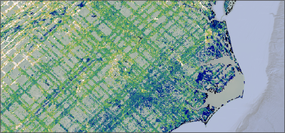
This is a screen capture from the GEDI L4B mean aboveground biomass density layer showing the crisscross pattern of GEDI’s laser tracks on the Earth’s terrestrial surface.
This screen capture from the GEDI L4B mean aboveground biomass density layer shows the crisscross pattern of GEDI’s laser tracks on the Earth’s terrestrial surface.

“There is a lot of interest in being able to look at much finer scales than national inventory data can provide. For example, you may have a landowner that wants to take credit for preserving 100 acres of their forest. Well, how do we understand how much biomass is being held in that forest? In the US, the existing National Forest Inventory, the USDA Forest Service’s Forest Inventory and Analysis program, does not have anywhere near that kind of granularity. GEDI provides these kinds of data, which could be used to monitor carbon offset projects and ask questions about how much carbon we could store in the future for a particular forest.”

As with the earlier GEDI products, Level 4B data will be available in NASA's Earthdata Cloud, which gives users the opportunity to access and process large quantities of data, and promotes opportunities for innovation around new services, such as sequencing data to support machine learning and artificial intelligence.

“The GEDI Level 4B product will be available as cloud-optimized GeoTIFF files (COG) and NASA’s Earthdata Search will enable discovery and access,” said Shrestha. The product will also be available from the ORNL DAAC Subsetting Tools, as well as through its Spatial Data Access Tool (SDAT), which provides visualizations and Open Geospatial Consortium web services that allow users to select the spatial extent, format, projection, and resolution of the data they want to preview or download.

The GEDI data products suite also contains another gridded product, GEDI Level 3 Version 2, which provides canopy-height and ground elevation estimates at the same 1-km grids. Compared to discontinuous footprint-level products, which provide data as billions of 25m-footprint samples, the gridded products provide continuous, wall-to-wall estimates.

To learn more about the GEDI mission and GEDI data products, see the following online resources:

GEDI mission website

GEDI data can be searched for and discovered using the EOSDIS Earthdata Search application.

Information about using the Earthdata Cloud is available on NASA's Earthdata website.
LP DAAC GEDI Landing Pages:

ORNL DAAC GEDI Landing Pages:

Last Updated