AGU Presentation Previews

Preview the presentations that IMPACT team members will be delivering at the American Geophysical Union Fall Meeting.
author-share

We are into October, and the American Geophysical Union's #AGU20 Fall Meeting is fast approaching. Even though it will be a virtual conference, we are looking forward to interacting with all of you. Over the next several weeks we will be previewing a number of the presentations that IMPACT team members will be delivering at #AGU20.

A Deep Learning Approach for Surface PM2.5 Estimations from Geostationary Satellite and Numerical Model Data
Session A008 — Earth Observations from Geostationary Satellites: Applied Research and Applications III Posters

Fine particles released by activities such as vehicle exhaust, the burning of fuels, and forest fires are known to cause severe impacts on public health. Particulate matter (PM) with a diameter less than or equal to 2.5 μm, referred to as PM2.5, is known to cause or exacerbate cardiovascular and respiratory illnesses. The analysis of data and the derivation of the relationships among them to estimate surface PM2.5 can be a tedious task and can require significant computation and processing. A deep learning approach is appropriate for such complex estimation problems as it defines relations among multiple non-linear parameters.
Image
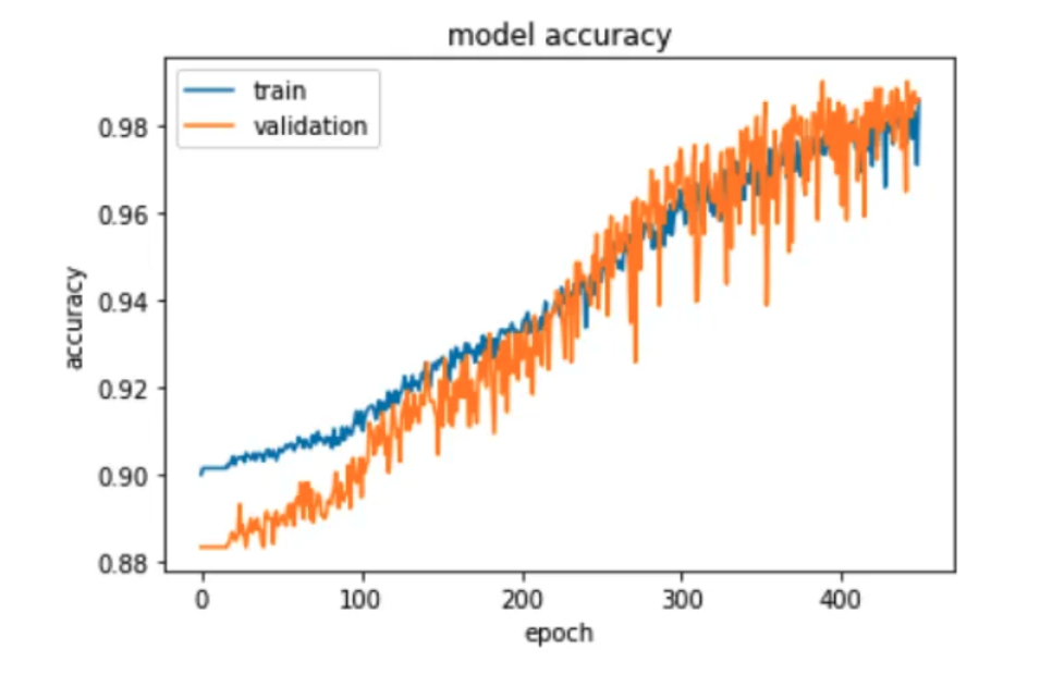
An example of the LSTM classification results.


Manisha Khatri will present a deep learning neural network model that estimates PM2.5 levels by utilizing the aerosol optical depth retrievals from Geostationary Operational Environmental Satellite (GOES) 16 and factors in the data from numerical modeling such as the National Oceanic and Atmospheric Administration's High Resolution Rapid Refresh model which resolves near real-time atmospheric conditions. The presentation will illustrate the development of the neural network model and its ability to provide estimations of surface PM2.5 over the contiguous U.S.

Improved Open Data Sharing of NASA Airborne and Field Investigation Data
Session SY028 — Data for All: Open Data Sharing and Analytics to Empower Science eLightning

Airborne and field investigations are relatively short-term efforts designed to meet specific scientific research objectives, to support the development of new instrumentation, or to provide calibration and validation data for existing satellite sensors or algorithms. Effective discovery, access, and use of airborne and field investigation data require accurate and ample metadata describing both the data and the context in which the data were collected. The Airborne Data Management Group (ADMG) has the responsibility of ensuring that NASA investigation data are discoverable and accessible to scientists and other interdisciplinary and applications-oriented users. ADMG advises data center personnel and investigation science teams on best practices for airborne and field data management and provides investigation teams with training and assistance in data handling and metadata assignment.

Image
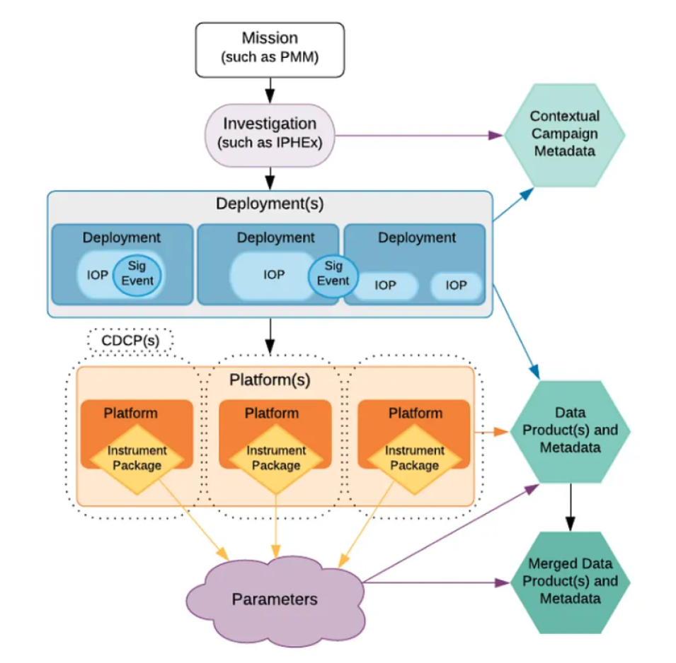
Simplified information model used to develop an airborne and field data inventory.


Deborah Smith, the lead of the ADMG team, will be presenting efforts to bring important investigation data to data centers for open data access. Historically, investigations have not been systematically archived. She will present the carefully constructed airborne and field investigation inventory resulting from ADMG efforts and share challenges and solutions to data discovery and access issues that are unique to airborne and field data. This eLlightning poster will summarize this important work.

Semantic Segmentation with Deep Convolutional Neural Networks for Automated Dust Detection in GOES-R Satellite Imagery
Session A123 — Data-Driven Prediction of Hazardous Air Quality Events I

Airborne dust, including dust storms and weaker dust traces, can have deleterious and hazardous effects on human health, agriculture, solar power generation, and aviation. Although Earth observing satellites are extremely useful in monitoring dust using visible and infrared imagery, dust is often difficult to visually identify in single band imagery due to its similarities to clouds, smoke, and underlying surfaces. Furthermore, night-time dust detection is a particularly difficult problem, since radiative properties of dust mimic those of the cooling, underlying surface.

Image
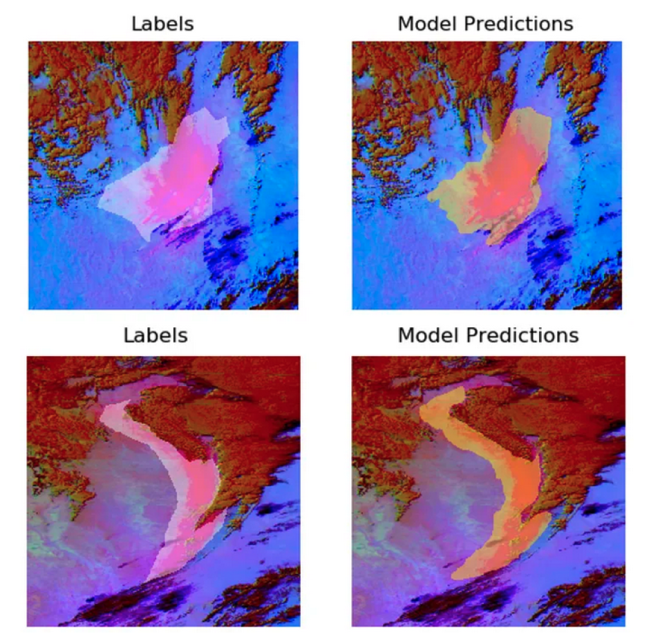
Subject matter labels of dust (left); the AI model's prediction (right).


IMPACT developed a deep learning, U-Net image segmentation model to identify airborne dust at night leveraging six GOES-16 infrared bands, with a focus on infrared and water vapor bands.The U-Net model architecture is an encoder-decoder convolutional neural network that does not require large amounts of training data, localizes and contextualizes image data for precise segmentation, and provides fast training time for high accuracy pixel-level prediction.

Talha Khan will highlight the collection of the training database, the development of the model, and the preliminary model validation. With further model development, validation, and testing in a real-time context, probability-based dust prediction could alert weather forecasters, emergency managers, and citizens to the location and extent of impending dust storms.

Public-Private Partnerships to Enable Discovery, Access and Use of NASA's Open Earth Science Datasets
Session SY028 — Data for All: Open Data Sharing and Analytics to Empower Science eLightning

Rapid technology developments are changing the conduct of data-driven research in the Earth science community. Sensor improvements, accelerated data gathering rates, and heterogeneous data types are all contributing to the big data phenomenon. NASA's Earth Science Data Systems (ESDS) Program seeks to address these rapid technology developments by engaging with members of the Earth science community and the private sector working in the areas of big data and cloud computing to evolve leading edge data systems and ensure that data, ancillary information, and tools are free and open to all users.

Elizabeth Fancher will present an overview of current partnerships supporting open data initiatives and share lessons learned. She will demonstrate how collaborating with these partners help ESDS investigate new strategies to enable the discovery, access, and use of high value NASA Earth science data sets on the cloud in conjunction with complementary data sets from other collaborating agencies. She will also cover how these partnerships help identify gaps and capabilities required to enable new methods for search and discovery as well as offer innovative solutions for conducting research across large data volumes.

More information about IMPACT can be found at NASA Earthdata and the IMPACT project website.

Last Updated