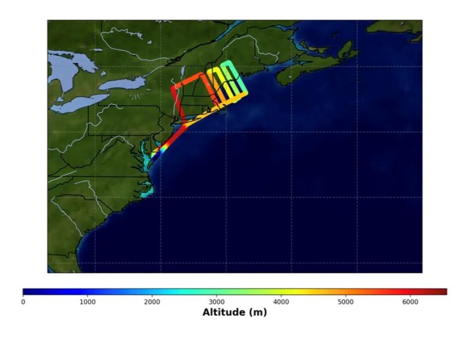
Anabelle shared that she had a positive experience working with the ADMG team and CASEI:
"This summer I was mentored by a team filled with intelligent and hard-working people. I always felt comfortable asking questions, and I gained skills I would not have learned in the classroom. Working with ADMG showed me that a diverse team is best suited for driving innovation and accomplishing amazing things."
In the final week of her internship, Anabelle met with Heidi Mok, a Development Seed developer who supports CASEI operations, and ADMG team lead Stephanie Wingo to discuss how her work would soon contribute towards a new feature for CASEI users to explore. Using Figma, a collaborative web design application, they prototyped possible implementations of flight path visualizations on CASEI’s campaign pages.
Check out Anabelle’s LinkedIn profile.
Opening Up the SmallSat Data Explorer
Noam Mayerfeld and Shrey Gupta were tasked with enhancing the SmallSat Data Explorer (SDX) tool. In response to the need for improved data discoverability and analysis, the two developed a data processing service that will enhance the way end-users interact with the expansive data archive within the SDX. This processing service empowers users with the ability to explore the data before downloading it. The service design allows users to select from an assortment of curated data processing algorithms. This open access to algorithms ensures that users, regardless of their technical expertise, can harness the power of complex analytical tools.
In describing the architecture, Shrey noted,
"What’s nice about the workflow orchestrator is that it handles load. Because time is not an issue, we can control how much space we’re using (from a compute perspective) without worrying about downtime. We used Airflow with Lambda, a serverless compute instance, that will run the algorithms for up to 15 minutes asynchronously."
Commercial SmallSat Data Acquisition (CSDA) Program data are restricted to authenticated science users as defined by vendor specific end user license agreements (EULAs). The processing service generates derived data products which may be accessible to unauthenticated users, leaving the original data inaccessible. Consequently, the service dramatically broadens the accessibility and utility of CSDA data, catering to a wide range of individuals who can derive value from it.
Noam describes the value he got out of the internship:
"My passion lies in building complex systems and programs that will make a real visible difference in the world. Earth Science research can play a major role in understanding, and maintaining, the planet we call our own, so I was privileged to play a small role in that effort."
You can view Noam’s LinkedIn profile and Shrey’s LinkedIn profile.
Using Machine Learning to Track Abandoned Oil Wells
Tuong Phung, a senior at the Massachusetts Institute of Technology (MIT), interned with the Machine Learning team within IMPACT. Under mentor Muthukumaran (Kumar) Ramasubramanian’s guidance, he built on previous work by Lilly Thomas and used machine learning and high-resolution satellite data to detect and track abandoned oil wells. The overall goal of this project is to develop a system that can monitor wells over time and identify when active wells are abandoned.
Abandoned oil wells are a significant, but unpredictable, source of methane emissions. Identifying and tracking them enables researchers to better understand and ultimately mitigate their environmental impact. As part of his project, Tuong used Detectron2, a popular open-source research platform for object detection and segmentation to train a model on satellite images of active oil wells. He also analyzed high-resolution satellite data using Rasterio, a Python library for working with geospatial raster data and pyproj, another Python library used for cartographic projections and coordinate transformations.
Asked about his interest in this field of research, Tuong responds:
"As a researcher, I am strongly interested in the applications of AI to problems in science and engineering. This project was a great opportunity to use machine learning to address an important problem related to climate change: the identification and tracking of abandoned oil wells to better understand and ultimately mitigate their environmental impact."
Global methane emissions are a recognized concern and monitoring them is a high priority for researchers. Data from the MethaneSAT mission (currently scheduled for a January 2024 launch) will be used in conjunction with the time series analysis system Tuong developed. By combining the data from MethaneSAT with the detection and tracking of abandoned oil wells, researchers will be able to identify regions of interest and gain a more comprehensive understanding of methane emissions and their sources.
Check out Tuong’s LinkedIn profile.
More information about IMPACT can be found at NASA Earthdata and the IMPACT project website.
