Introduction
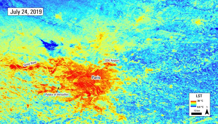
For the second time in as many months, Europe was gripped by an extreme heat wave, breaking temperature records in 12 countries. Record high temperatures were set on Thursday, July 25, 2019, in the Netherlands at 40.4 °C (104.7 °F), and Belgium at 41.8 °C (107.2 °F). Germany reached 42.6 °C (108.7 °F), as did Paris, France, which broke a record that had stood for over 70 years by more than 2 degrees Celsius.
For Europeans, this may sound like a “broken record” as the continent suffered a separate extreme heat wave just a month prior in late June, when eight countries experienced record-breaking heat, including France’s all-time highest recorded temperature at 45.9 °C (114.6 °F). While these temperatures are still far from the highest recorded temperatures on Earth, they are abnormal for Europe, where less than 5% of households are air-conditioned. Exposure to extreme heat waves can lead to significant health risks, such as heat stroke and cardiovascular and respiratory failure, which can result in death. The elderly population is particularly at risk during these extreme heat events.
Extreme heat events are even more dangerous in large cities, as areas of dense impervious surfaces from buildings, roads, and parking lots absorb heat during the day and reradiate the heat back into the city at night. This leads to overall warmer temperatures in cities than the surrounding areas, known as the Urban Heat Island (UHI) effect. Fortunately, there are solutions that can be put in place to mitigate the impacts of UHIs and extreme heat waves in cities. Those include long-term solutions, such as increasing green space and whitening roofs.
There are also potential short-term solutions, such as installing mist spray systems in public places. One way to identify at-risk “hot spots” within cities that would benefit from these solutions during heat waves is through remote sensing. One major benefit in using remote sensing data, in addition to in-situ weather station temperature readings, is that they provide a spatially continuous map of urban temperatures. Remote sensing sensors detect land surface temperature (LST), or the temperature of the surface being detected, similar to air temperature measured at weather stations, but the two measurements can differ, especially during the day as LST skyrockets over sunlit areas.
NASA’s ECOsystem Spaceborne Thermal Radiometer (ECOSTRESS) is a new sensor that captures LST at 70-meter (m) resolution. Installed on the International Space Station (ISS), ECOSTRESS is novel in that it captures multispectral thermal observations globally from space at relatively high resolutions at different times throughout the day.


