In spring 2015, NASA DEVELOP teams used NASA Earth observation data distributed by NASA's Land Processes Distributed Active Archive Center (LP DAAC) in several of their projects. These data included Moderate Resolution Imaging Spectroradiometer (MODIS) and Advanced Spaceborne Thermal Emission and Reflection Radiometer (ASTER). MODIS and ASTER data were applied to assess landslide hazards in the Koshi River Basin in the Himalayans, monitor wetland change in the Great Lakes shoreline, and create habitat suitability maps to measure vector-borne risk in the southwestern United States. They were also used to detect invasive plants in costal Mississippi, as a proxy for air temperature for agriculture in Washington State, and to assist with decision-making for water management in Peru.

For more information about all of the Spring 2015 DEVELOP projects, please visit the DEVELOP archive.

Featured Project: Drought Monitoring in Uruguay 

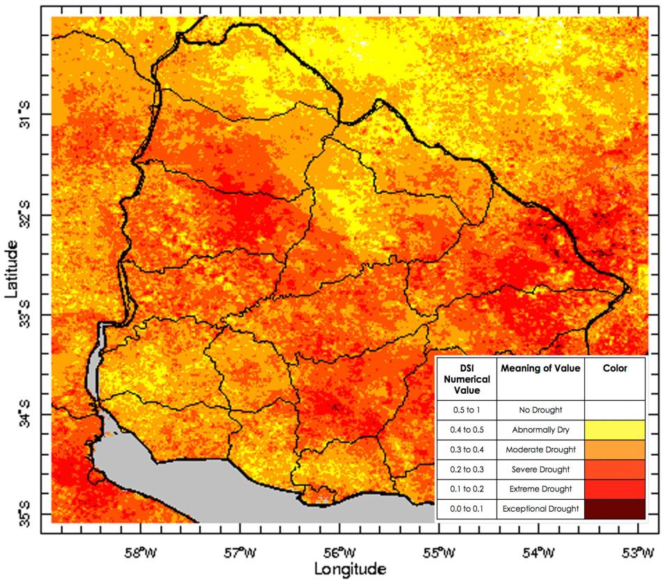
One of the projects, Taking Droughts from Earth to Space, incorporated MODIS data to develop a drought-monitoring tool to help provide drought-related information to local stakeholders in the community. Droughts have been a major concern for the country of Uruguay, affecting their agricultural and energy sectors.
Image
Image Caption

The image above demonstrates the drought severity index (DSI) for Uruguay in March 2015, it combines MODIS LST (MOD11A2), MODIS spectral bands (MOD09A1) to form an NDWI, and NOAA precipitation data to create a map showing the level of drought severity throughout the country.

Instruments and Techniques Used

This project sought to create a drought severity index (DSI) for the country of Uruguay using solely remotely sensed products. The team accomplished this using MODIS daytime land surface temperature products (MOD11A2) as well as creating a normalized difference water index (NDWI) from MODIS spectral bands. Their final product was validated against in situ station data provided from project partners in Uruguay.

About the NASA DEVELOP National Program

The DEVELOP National Program is part of NASA’s Applied Sciences Program. Participants from around the country join the DEVELOP program for 10-week terms to apply data acquired by NASA Earth-observing satellites to bridge the gap between science and society. DEVELOP participants work with local, state, and federal partners to create maps and other products in nine focus areas including Agriculture, Climate, Disasters, Ecological Forecasting, Energy, Health and Air Quality, Oceans, Water Resources, and Weather. Frequently, these projects utilize data that is distributed by NASA’s LP DAAC, such as data from the MODIS instrument, which is aboard the NASA Terra and Aqua satellites, and ASTER, onboard Terra. These data are used to map a variety of environmental changes across the globe.

Publication Reference

Lessel, J and Sweeney, A., 2015, Taking droughts from Earth to space: Earthzine, accessed May 21.

Details

Last Updated

June 13, 2025

Published

July 1, 2015

Data Center/Project

Land Processes DAAC (LP DAAC)