During the summer 2020 term of NASA’s DEVELOP National Program, participants used geospatial data and technologies to investigate, analyze, and monitor several issues around the world. Some of the topics explored throughout the term included air quality, climate, conservation, energy, flooding, habitat, land cover change, urbanization, water resources, transportation, and wildfires. Each project completed by a DEVELOP team is conducted in partnership with agencies or organizations local to the study area. Fundamental to the analytical and geospatial component of each of these projects is NASA Earth science remote sensing data.
Several of these projects used data distributed by NASA's Land Processes Distributed Active Archive Center (LP DAAC), including data collected by the Moderate Resolution Imaging Spectroradiometer (MODIS) aboard NASA’s Terra and Aqua platforms, NASA’s Shuttle Radar Topography Mission (SRTM), which flew aboard the space shuttle Endeavour in 2000, and the Global Ecosystem Dynamics Investigation (GEDI) and Ecosystem Spaceborne Thermal Radiometer Experiment on Space Station (ECOSTRESS) instruments aboard the International Space Station (ISS).
All projects conducted in the summer term, as well as in past terms, can be found in the DEVELOP archive.
Featured Project: Urban Growth Impact in Huntsville, Ala.
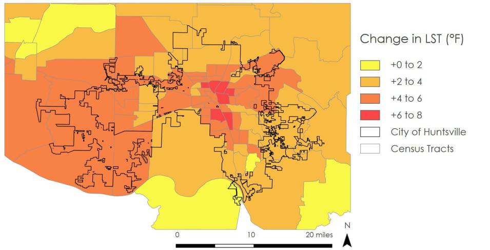
Urbanization is often linked to the amplification of the urban heat island effect in cities. One reason is that urbanization results in increased impervious surface area (rooftops and asphalt), and decreased vegetation cover (agriculture, tree cover, grassland), which in turn leads to higher local temperatures in those areas compared to surrounding regions. The city of Huntsville, Alabama, has recently experienced rapid growth in part due to the city’s engineering industry. The Huntsville Urban Development DEVELOP team set out to use NASA Earth science remote sensing data to observe the impacts urban growth has had on the city of Huntsville’s environment.
