User Profile: Dr. Gonzalo González Abad

NASA Earth science data help Dr. Gonzalo González Abad produce retrievals of formaldehyde and other atmospheric trace gases.

Dr.  Gonzalo González Abad, Center for Astrophysics, Smithsonian Astrophysical Observatory

Image
Dr. Gonzalo González Abad, an atmospheric physicist at the Center for Astrophysics and a member of NASA's Goddard Earth Sciences Data and Information Services Center (GES DISC) User Working Group, produces data products of formaldehyde and other trace gas species using NASA Earth science data. Image courtesy of González Abad.

Research Interests: Space-based measurements of atmospheric trace gases and the application of these measurements to the study of air quality.

Research Highlights: When people speak of trace gases associated with climate change, greenhouse gases like carbon dioxide, methane, and nitrous oxide get most of the attention. However, there are a host of other atmospheric trace gases that, even though they don’t occur in large quantities, are important to life on Earth and play critical roles in atmospheric processes.

Two examples of such trace gases are formaldehyde and glyoxal, both of which can react with nitrogen oxides to increase levels of ozone, another greenhouse gas that impacts climate, air quality, and the biosphere. Formaldehyde and glyoxal can also react with other atmospheric chemicals to create secondary aerosols, which may promote cloud formation and boost Earth’s albedo (the planet’s capacity to reflect solar radiation back into space), leading to regional cooling. Therefore, gathering specific information on the concentrations and sources of these trace gases and how they behave in the atmosphere is essential for monitoring air quality, responding to the effects of climate change, and evaluating the policies and regulations governing air quality and the release of atmospheric pollutants.

Among the atmospheric scientists engaged in such work is Dr. Gonzalo González Abad, an atmospheric physicist at the Center for Astrophysics, a collaboration between the Smithsonian Astrophysical Observatory and Harvard College Observatory in Cambridge, Massachusetts.

“The goal of my work is to produce retrievals of trace gas species relevant to air quality,” González Abad said. “In particular, I am working to develop consistent, long-term observations of formaldehyde, water vapor, glyoxal, bromine monoxide, and ozone from 1996 to the present.”

González Abad is especially interested in formaldehyde and glyoxal, which play important roles in atmospheric chemistry, including the production or destruction of ozone in the troposphere.

“These species do not have large concentrations in the stratosphere. They are mostly in the troposphere and the boundary region between [the troposphere and the stratosphere],” he said. “They regulate the amount of oxidative power of the atmosphere in conjunction with nitrogen dioxide, so they play an important role in ozone production and destruction and in atmospheric pollution. They also play a role in the production of secondary aerosols, or aerosols that form through coagulation of water and other particles. This is how these types of aerosols grow.”

Formaldehyde is often a byproduct of the oxidation of another trace gas: isoprene, a biogenic chemical produced during photosynthesis and emitted mainly from the leaves of woody plants. Isoprene is a volatile compound known to react with hydroxyl radicals, a type of molecule that reduces the oxidative capacity of the atmosphere and increases the survival of compounds like methane, which contributes to global warming and is the primary contributor to the formation of ground-level ozone. By monitoring atmospheric concentrations of formaldehyde, scientists can zero-in on sources of isoprene emissions and track its concentration in the atmosphere.

“NASA doesn’t have a long-term record of formaldehyde retrievals from multiple satellites. The European Space Agency [ESA] has a long-term record for formaldehyde using [data from] four satellites, but it doesn’t include data from the Ozone Profiler and Mapping Suite (OMPS) instrument,” González Abad said. “OMPS is now the workhorse for NASA and NOAA, so the reason we are developing this [formaldehyde data product] is because we can and because we want to use all the sensors that are available from NASA and NOAA, and also ESA.”
Image
González Abad and his colleagues are using data from the OMPS instrument aboard the NOAA-20 satellite (left) and the TROPOspheric Monitoring Instrument (TROPOMI) aboard the Copernicus Sentinel-5 Precursor (Sentinel-5P) satellite (right), to produce a long-term data record of atmospheric formaldehyde. They also will use data from these instruments to validate observations from NASA’s Tropospheric Emissions: Monitoring Pollution (TEMPO) mission, which will characterize air quality over the continental United States. Credits: NOAA (NOAA-20 image) and ESA (Sentinel-5P image).

In addition to OMPS, which flies aboard the joint NASA/NOAA Suomi National Polar-orbiting Partnership (Suomi NPP) and the Joint Polar Satellite System’s (JPSS) NOAA-20 and NOAA-21 satellites (and will be aboard the NOAA-22 satellite, which is scheduled for launch in 2027), other sensors González Abad and his colleagues use are the Ozone Monitoring Instrument (OMI) aboard NASA’s Aura satellite and the Tropospheric Monitoring Instrument (TROPOMI), which is the single instrument aboard the ESA Sentinel-5P spacecraft. Incorporating the data from these instruments into a single long-term data record will provide a more complete picture of how formaldehyde concentrations have changed over time.

“OMI [launched in 2004] is still going, although not for much longer. It provides almost two decades of data. By stitching all that data together, we have a continuous thread that allows you to see how things have changed or are changing. That’s kind of important for climate studies or for evaluating the efficiency or effectiveness of [environmental] policies,” González Abad said. “Then OMPS arrives [in 2012] and you can stitch them together too. And now we have TROPOMI, so we’re [trying to develop] a better, more complete picture.”

Of course, there’s more to making a long-term data record than just linking the data record from one instrument to that of another. 

“The complication is that these retrievals are noisy because the signal is quite small,” González Abad admits. “There are biases within the different instruments, so it is not that easy to create something consistent across decades and instruments.”

Image
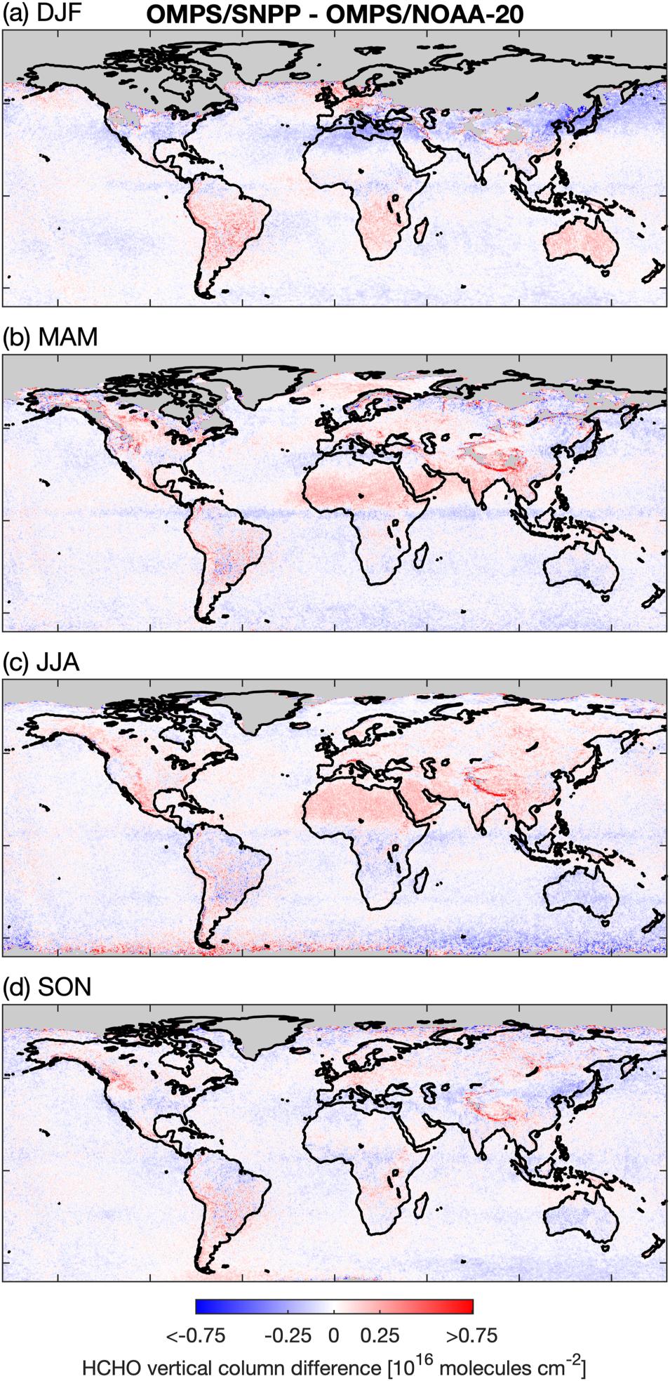
This graphic of OMPS data from Suomi NPP and NOAA-20 shows the differences among seasonal mean concentrations of formaldehyde (HCHO) in vertical columns of the atmosphere in 2019. Red areas indicate the highest concentrations, while blue areas indicate the lowest. Letters above each image indicate the months of the year covered by the specific image. Image courtesy of González Abad.

To address that noise and bias, González Abad and his colleagues rely on data from several sources, including NASA’s Goddard Earth Sciences Data and Information Services Center (GES DISC). Located at NASA's Goddard Space Flight Center in Greenbelt, Maryland, GES DISC—one of 12 Distributed Active Archive Centers (DAACs) in NASA’s Earth Observing System Data and Information System (EOSDIS)—manages, archives, and distributes data, tools, and resources pertaining to atmospheric composition, atmospheric dynamics, global precipitation, and solar irradiance.

“To create the best possible products, we leverage information from multiple sources, both observational and modelled," González Abad said. "For example, we use data from the Modern-Era Retrospective analysis for Research and Applications, Version 2 (MERRA-2) and Goddard Earth Observing System (GEOS) Composition Forecasting (GEOS-CF) simulations, aerosol information from sensors such as OMI, and Moderate Resolution Imaging Spectroradiometer (MODIS) surface reflectance, chlorophyll, snow cover, and other products. The products we use as inputs in our retrieval algorithms help to simulate the conditions of the observation. That is essential to achieve accuracy.”

One of the products González Abad and his colleagues created, a multi-year formaldehyde product produced with data from the OMPS instruments aboard the Suomi NPP and NOAA-20 satellites, was the subject of a 2023 paper published in the American Geophysical Union journal Earth and Space Science that compares the formaldehyde observations of the two OMPS instruments with those from TROPOMI.

The researchers found that the OMPS formaldehyde products both extend and complement the global afternoon formaldehyde data records that began with OMI in 2004, and that their retrieval algorithm could also be applied to the OMPS instruments on future JPSS satellites. These findings are significant, as their application to the OMPS instruments of the future would ensure a consistent long-term stable data record of global afternoon formaldehyde observations into the 2030s.

“With future Sentinel-5 instruments planned for morning orbits, OMPS [will be] the only planned ultraviolet hyperspectral instrument in afternoon orbit post-TROPOMI, and therefore the only instrument capable of continuing the afternoon [formaldehyde] data record that began with OMI in 2004,” said González Abad.

In addition to producing trace gas products with data from the OMPS instruments, González Abad is also working to develop products with data from NASA’s Tropospheric Emissions: Monitoring Pollution (TEMPO) mission. “Currently I'm focusing all my efforts on retrievals of nitrogen dioxide and formaldehyde from TEMPO, the new NASA geostationary instrument devoted to characterizing air quality over the continental United States with unprecedented temporal and spatial resolution,” he said.

The TEMPO instrument, an ultraviolet and visible spectrometer, was completed in 2019 and launched into geostationary orbit about 22,000 miles above Earth’s equator on April 7, 2023. From this vantage point, TEMPO will monitor daily variations of ozone, nitrogen dioxide, sulfur dioxide, formaldehyde, glyoxal, bromine monoxide, iodine monoxide, water vapor, aerosols, cloud parameters, ultraviolet radiation, and foliage properties from the Atlantic to the Pacific, and from Mexico City and the Yucatan Peninsula to the Canadian oil sands. The instrument will resolve pollution levels to regions of several square miles—far better than existing limits of about 100 square miles.

Image
From its vantage point in geostationary orbit 22,000 miles above Earth’s equator, TEMPO will measure air pollution in North America from the Atlantic Ocean to the Pacific, and from Mexico City to the Canadian oil sands. Credit: NASA/USGS/SAO.

González Abad, along with lead author Dr. Peter Zoogman from the Center for Astrophysics and a team of other researchers, published a paper on TEMPO’s advanced pollution-monitoring capabilities in the Journal of Quantitative Spectroscopy and Radiative Transfer in 2017. In it, the authors noted how TEMPO will “[collect] the space-based measurements needed to quantify variations in the temporal and spatial emissions of gases and aerosols important for air quality with the precision, resolution, and coverage needed to improve our understanding of pollutant sources and sinks on sub-urban, local, and regional scales and the processes controlling their variability over diurnal and seasonal cycles.”

Now that TEMPO is in orbit and sending back initial data, González Abad believes the instrument’s contributions to the study of atmospheric trace gases will be substantial.

“We obtained the first measurements on August 2 [2023], and we are still in the commissioning phase, characterizing the performance of the instrument and refining the data processing algorithms,” he said. “The initial results and analysis obtained from first light observations are promising. Once TEMPO data are released, they will revolutionize atmospheric chemistry.”

That revolution will come in the form of data with better spatial and temporal resolution than are currently available from satellites in low Earth orbit (LEO).

“Right now, with the OMI, TROPOMI, and OMPS on the JPSS satellites [in LEO], we can measure these gases once per day, maybe twice a day at high latitudes, but that’s it. With TEMPO [in a geostationary orbit], we are going to receive measurements of the same location 10 times per day,” González Abad said. “From that point of view, it will bring us a lot of information that will help us understand the cycles of atmospheric chemistry during the day. And then there is the spatial resolution that will allow us to see things we couldn’t before. This will help us better constrain emissions, produce better air quality forecasts, and possibly give us new insights.”

In addition, the daily observations from OMPS and TROPOMI will complement the data from TEMPO, the Geostationary Environmental Monitoring Spectrometer (GEMS, which provides observations of the Korean peninsula and Asia-Pacific region), and forthcoming ESA Sentinel-4 satellite by seeing what these missions can’t.

“[TEMPO, GEMS, and Sentinel-4] are geostationary platforms and are only looking at the Northern Hemisphere. So, if we didn’t have the satellites in low Earth orbit, then we wouldn’t have eyes on the Southern Hemisphere,” González Abad said. “Some people would argue that maybe that area is even more important to keep an eye on it because the [Amazon] rainforests are there and most of the fast-evolving societies of the Global South are there, so it’s crucial to maintain these capabilities.”

Further, González Abad noted that the data from the LEO satellites, even if it’s just once per day, will be helpful in validating the data he and his colleagues get from TEMPO. “Even if we had geostationary satellites looking at the Southern Hemisphere, we’d still need these capabilities to make sure the data are cohering,” he said.

Validation is a critical part of González Abad’s efforts to produce data products for formaldehyde, glyoxal, and other trace gas species, and he praises NASA’s DAACs for helping him get the data he needs quickly and easily.

“It’s very easy to use NASA data. If I want MERRA-2 data, I can go to Earthdata Search and I don’t even need to know that GES DISC is the source. So, kudos to GES DISC and the other DAACs,” he said. “They are really concerned about what the community needs. Not only the community in the U.S., but around the world as well.”

González Abad also credits GES DISC for providing the services that help him and his colleagues share the data products they create with the global atmospheric chemistry community.

“The data I generate need to be distributed to the community freely and efficiently. [GES DISC] is so helpful, not only in helping us distribute the data, but in curating them, helping us prepare the [dataset] documentation, and making sure that the data are always available,” González Abad said. “If we had to take care of that, that would be a job in itself.”

Representative Data Products Used or Created:

Available through NASA's GES DISC:

Other data products used:

Read about the Research:

Kwon, H.-A., González Abad, G., Nowlan, C.R., Chong, H., Souri, A.H., Vigouroux, C., et al. (2023). Validation of OMPS Suomi NPP and OMPS NOAA-20 Formaldehyde Total Columns with NDACC FTIR Observations. Earth and Space Science, 10(5), e2022EA002778. doi:10.1029/2022EA002778 

Nowlan, C.R., González Abad, G., Kwon, H.-A., Ayazpour, Z., Chan Miller, C., Chance, K., et al. (2023). Global formaldehyde products from the Ozone Mapping and Profiler Suite (OMPS) nadir mappers on Suomi NPP and NOAA-20. Earth and Space Science, 10(5), e2022EA002643. doi:10.1029/2022EA002643

Souri, A.H., Nowlan, C.R., González Abad, G., Zhu, L., Blake, D.R., Fried, A., Weinheimer, A.J., Wisthaler, A., Woo, J.-H., Zhang, Q., Chan Miller, C.E., Liu, X., & Chance, K. (2020). An inversion of NOx and Non-Methane Volatile Organic Compound (NMVOC) Emissions Using Satellite Observations During the KORUS-AQ Campaign and Implications for Surface Ozone over East Asia. Atmospheric Chemistry and Physics, 20(16): 9837-9854, doi:10.5194/acp-20-9837-2020

Zoogman, P., Liu, X., Suleiman, R.M., Pennington, W.F., Flittner, D.E., Al-Saadi, J.A., Hilton, B.B., Nicks, D.K., Newchurch, M.J., Carr, J.L., Janz, S.J., Andraschko, M.R., Arola, A. B., Baker, D. B., Canova, P., Chan Miller, C.R., Cohen, C.,Davis, J.E., Dussault, M.E., Edwards, D.P., Fishman, J., Ghulam, A., González Abad, G., et al. (2017). Tropospheric emissions: Monitoring of pollution (TEMPO). Journal of Quantitative Spectroscopy and Radiative Transfer, 186: 17-39. doi:10.1016/j.jqsrt.2016.05.008

Explore more Data User Profiles

Last Updated