Earth Science Data Roundup: July 2025

A summary of datasets, products, and resources released by NASA’s Distributed Active Archive Centers (DAACs) in June 2025.

Atmospheric Science Data Center (ASDC)

WNA-BackTraj FLEXPART Dispersion Model Data Released

NASA's ASDC released data for the Western North America (WNA) Back Trajectory (BackTraj) FLEXible PARTicle (FLEXPART) dispersion model. Backward simulations of airmass transport using a Lagrangian Particle Dispersion Model framework can establish source-receptor relationships, supporting analysis of source contributions from various geospatial regions and atmospheric layers to downwind observations. For each receptor, the FLEXPART dispersion model was used to achieve 15-day backwards source-receptor relationships calculations, proving global simulations at high temporal (hourly) and spatial (1 degree x 1 degree) resolution, from the surface up to 20 kilometers above ground level. 

This product retains detailed information for each receptor, including the gridded ozone value product, allowing users to illustrate and identify source contributions to various subsets of ozone observations in the troposphere above WNA over nearly three decades at different vertical layers and temporal scales, such as diurnal, daily, seasonal, intra-annual, and decadal.

Access WNA-BackTraj FLEXPART Dispersion Model data and more information.

Global Hydrometeorology Resource Center Distributed Active Archive Center (GHRC DAAC)

TRMM Brazil ER-2 DOPPLER RADAR (EDOP) Version 1 Dataset Released

NASA's GHRC DAAC released the TRMM Brazil ER-2 Doppler Radar (EDOP) Version 1 dataset. The Tropical Rainfall Measuring Mission-Large-Scale Biosphere-Atmosphere Experiment in Amazonia (TRMM-LBA) was a field campaign designed to collect data for validation of TRMM satellite measurements and numerical cloud models. The TRMM-LBA experiment was conducted in the southwestern part of the Amazon from November 1, 1998, to February 28, 1999, and provided detailed observations of precipitating systems from surface and aircraft instrumentation. 

EDOP flew aboard the NASA ER-2 aircraft during several field campaigns that took place between 1993 through 2007. These Level 1B EDOP data are organized into multiple files per flight, with each file covering several minutes of observations. Additionally, the files are divided between the forward and nadir pointing observations and are available in netCDF-4 format.
Access TRMM Brazil EDOP data and more information.

GPM Ground Validation Tipping Buckets UConn Dataset Now Available

The NASA Global Precipitation Measurement (GPM) Ground Validation Tipping Buckets University of Connecticut (UCONN) dataset is now available from GHRC DAAC. The dataset consists of rain rate data collected using Met One Model 380D precipitation gauges during three consecutive winter seasons at the University of Connecticut's main campus. 

The dataset contains two products: formatted gauge tips and interpolated one-minute rain rates for a year. Data files in this dataset are available in ASCII format from December 20, 2022, to October 28, 2024.

Access GPM Ground Validation Tipping Buckets UConn data and more information.

GPM GV R. M. Young Marine Anemometer UConn Dataset Released

The GHRC DAAC released the GPM Ground Validation R.M. Young Marine Anemometer UConn dataset, which includes wind speed and wind direction data collected by the Young Wind Monitor-MA. These data were collected during the GPM Ground Validation Field Campaign at the University of Connecticut, which provided an unprecedented set of wintry precipitation observations from multiple traditional and novel precipitation measurement instruments that can be used for validating ground-based and satellite remote sensing observations. 

The R.M. Young Marine Anemometer dataset files are available from December 7, 2022, through April 19, 2023, for the Dual-frequency Dual-polarized Doppler Radar site and from December 01, 2023 through May 21, 2024, for the GPM Atmospheric Instrumentation Laboratory) site in the CSV format.

Access the data and more information

Goddard Earth Sciences Data and Information Services Center (GES DISC)

OMI Sulphur Dioxide (OMSO2) Total Column 1-orbit Level 2 Swath 13x24 Kilometer V004 Dataset Updated

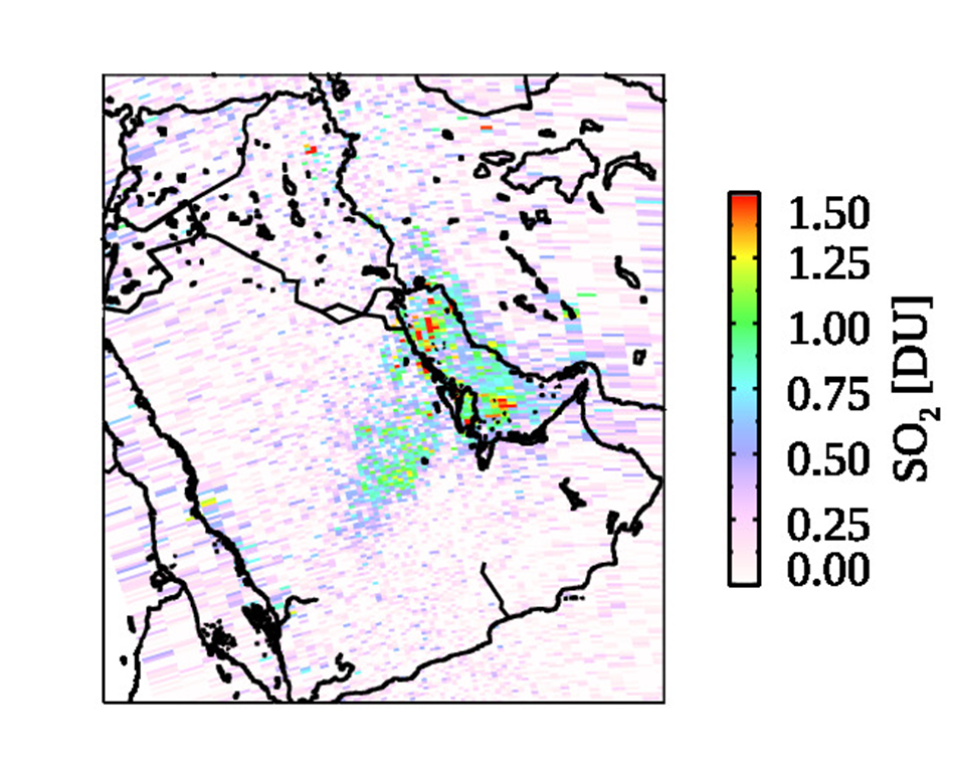
NASA's GES DISC updated the Ozone Monitoring Instrument (OMI) Sulphur Dioxide (OMSO2) Total Column 1-orbit Level 2 Swath 13x24 Kilometer data product with a principal component analysis-based algorithm with new SO2 Jacobian lookup tables and a priori profiles that significantly improve retrievals for anthropogenic SO2. The resolution of the data is 13x24 km2 at nadir, with a swath width of 2600 km and 60 pixels per scan line every 2 seconds. 

The data files contain different estimates of the vertical column density of SO2 depending on the users investigating anthropogenic or volcanic sources. The files also contain quality flags, geolocation, and other ancillary information, and are stored in the HDF-EOS5 format. Each file contains data from the daylit half of an orbit (~53 minutes). There are approximately 14 orbits per day.

Access the data and more information

Image
Image Caption

A sample OMSO2 image. Credit: GES DISC

Sentinel-6A GNSS-Precise Orbit Determination (POD) and Radio Occultation POD Level 1B Daily RINEX Version 1 Data Now Available

The Sentinel-6A GNSS-POD Level 1B Daily RINEX Version 1 and Level 1B GNSS Radio Occultation Daily RINEX V1 datasets are now available from NASA’s GES DISC. 

The Sentinel-6A GNSS-POD Level 1B Daily RINEX V1 (S6A_GN_1B_RNXD_AX_) dataset provides the Level 1B Global Navigation Satellite System (GNSS) Precise Orbit Determination (POD) data generated by the European Organization for the Exploitation of Meteorological Satellites (EUMETSAT) from the Sentinel-6A Michael Freilich satellite. The product provides raw satellite navigation system data and are available in Receiver Independent Exchange Version 3 (RINEX-3) format.

The Sentinel-6A Level 1B GNSS Radio Occultation Daily RINEX V1 (S6A_RO_1B_POD_RNX_) dataset provides Level 1B Global Navigation Satellite System (GNSS) Radio Occultation POD data generated by NASA’s Jet Propulsion Laboratory (JPL) from the Sentinel-6A Michael Freilich satellite. The product provides raw satellite navigation system data and are available in Receiver Independent Exchange Version 3 (RINEX-3) format.

Sentinel 6 is a collaborative mission between NASA's Jet Propulsion Laboratory (JPL) and EUMETSAT, with participation from European Space Agency (ESA), the National Oceanic and Atmospheric Administration (NOAA), and Centre National d’Études Spatiales (CNES) of France. Among the satellite's objectives is collecting high-resolution vertical profiles of temperature and humidity using a GNSS Radio Occultation sounding technique to assess temperature and humidity changes in the troposphere and stratosphere and to support numerical weather prediction.

Access the data and more information from each product link above.

National Snow and Ice Data Center Distributed Active Archive Center (NSIDC DAAC)

NSIDC DAAC Adds Datasets to the NASA Earthdata Cloud

NASA’s NSIDC DAAC has added the following datasets to the NASA Earthdata Cloud. The Earthdata Cloud, NASA’s archive of Earth observations, is hosted in Amazon Web Services (AWS). Users are encouraged to update direct download workflows and scripts to use the new Earthdata Cloud access URLs.

When data are added to Earthdata Cloud, the NSIDC DAAC replaces the legacy HTTPS File System URL on the dataset landing page with the Earthdata Cloud HTTPS File System URL. However, users can still find the legacy HTTPS URL in the DAAC’s Programmatic Data Access Guide.

The NSIDC DAAC User Services Office provides support for direct data download from the Earthdata Cloud HTTPS and basic access to our AWS Simple Storage Service (S3) buckets. For more details on these access options, please see the NASA Earthdata Cloud Data Access Guide.

OpenAltimetry Performance Updates - Improved Map Interface and Data Rendering

NSIDC DAAC announced performance improvements to the OpenAltimetry web application. These updates include: 

  • Improved data location representation at low resolution zoom levels.
  • Faster user interface performance while panning, zooming, and switching dates.
  • Reduced latency when rendering high resolution data points (after dynamic caching, see note below).
  • Implementation of NASA Harmony services for ordering subsetted HDF5 files.

Future improvements include the transition of OpenAltimetry to ICESat-2 v007 data, which is expected to bring additional performance improvements through cloud optimization.

For more information on the OpenAltimetry updates, including a description of known issues, visit the NSIDC DAAC website.

Image
Image Caption

A screen capture of the OpenAltimetry user interface showing ICESat-2 orbit tracks (green lines) and data acquisition points (green and yellow dots) near Maple City, Michigan, along the northern end of Lake Michigan on March 11, 2023. Credit: OpenAltimetry/NASA's NSIDC DAAC.

ICESat-2 Quick Look Product Availability Shifting from Legacy Data Archive to Cloud Access with Publication of Version 7

NSIDC DAAC announced that, as of June 17, Version 7 of the ICESat-2 Quick Look products have moved to the NASA Earthdata Cloud. Following the publication of Version 7, forward processing of Version 6 ended on June 18. 

The Version 6 data are only available on the legacy, on-premises data archive and NSICD DAAC does not plan to make the data available in the Earthdata Cloud. Version 7 data will not be available in the legacy, on-premises archive. Users will need to update their workflows to access the Version 7 data in the new Earthdata Cloud archive. The equivalent ICESat-2 standard products are currently available in Earthdata Cloud and can be used to help users learn how to update their code for the new archive. 

For more information on accessing data in Earthdata Cloud, please refer to the NASA Earthdata Cloud Data Access Guide.

DMSP SSM/I and SSMIS Data Processing to End July 31, 2025

NSIDC DAAC reports that the Defense Meteorological Satellite Program (DMSP) will cease production of three data products from the Special Sensor Microwave Imager/Sounder (SSMIS) and Special Sensor Microwave/Imager (SSM/I) data by July 31, 2025. The affected products are:

  • DMSP SSM/I Daily Polar Gridded Brightness Temperatures (nsidc-0001)
  • Sea Ice Concentrations from Nimbus-7 SMMR and DMSP SSM/I Passive Microwave Data (nsidc-0051)
  • Bootstrap Sea Ice Concentrations from Nimbus-7 SMMR and DMSP SSM/I (nsidc-0079)

In addition, there are four additional other products under assessment.

View a complete list of data products affected and information regarding potential solutions for continuing research. In the meantime, users are advised to reach out to Earthdata Support if they have any questions or need assistance with the transition. 

Oak Ridge National Laboratory Distributed Active Archive Center (ORNL DAAC)

ORNL DAAC Releases Four Datasets from the Arctic-Boreal Vulnerability Experiment (ABoVE) Field Campaign

NASA’s ORNL DAAC has released four new datasets from the Arctic-Boreal Vulnerability Experiment (ABoVE) Field Campaign. These datasets include the following:

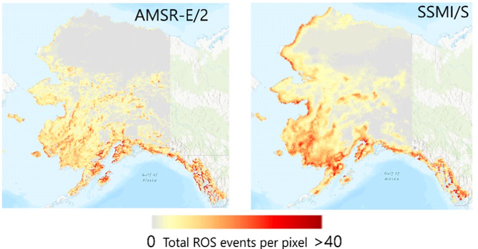
  • ABoVE: Rain-on-Snow Frequency and Distribution during Cold Seasons, Alaska, 1988-2023, which provides maps of rain-on-snow (ROS) events across Alaska for the individual cold season months from November to March using observations from two space-borne passive microwave radiometers: the Advanced Microwave Scanning Radiometer (AMSR-E) for EOS and Advanced Microwave Scanning Radiometer 2 (AMSR2) from 2002 to 2023, and the Special Sensor Microwave Imager and the Special Sensor Microwave Imager Sounder (SSMI/S) from 1988 to 2020. 

    The data are summations of the number of days with ROS events per pixel at 6-km spatial resolution per month or per 5-month water year. Winter months are when snowmelt from solar illumination is minimal and snow cover is widespread and relatively consistent throughout the region. The data are provided in GeoTIFF format.
     
  • ABoVE: Soil Moisture and Active Layer Thickness in Alaska, USA and Canada, 2005-2022, which provides soil thaw depth and moisture measurements and dielectric properties measured by different research teams at sites in Alaska and in the Northwest Territories, Canada. The dataset includes multiple observations per site and 528,703 total observations. 

    Metadata includes the location, time, geospatial coordinates, sampling technique, measurement teams, and field team contact information. Measurements were typically collected in August and September near the end of the thaw season and cover the period from 2005 to 2022. The data are provided in comma separated values (CSV) format.
     
  • ABoVE: Boreal Forest Resilience Study 2020-2022, Fairbanks, Alaska, which includes five metrics of forest resilience (recruitment, invasives, permafrost change, tree damage, and radial growth) at five recently burned forest sites between 2010 and 2019 near Fairbanks, Alaska. The sites were imaged by the Airborne Visible InfraRed Imaging Spectrometer-Next Generation (AVIRIS-NG) in 2017 and 2022 during ABoVE. Field measurements were conducted in 2021. There are 10 data files in comma-separated values format (CSV) in this dataset.
     
  • ABoVE: Landsat-derived Annual Dominant Land Cover in Boreal North America, 1986-2020, which contains a 30-meter resolution time series data of annual land cover classifications as the dominant plant functional type class for all of boreal Alaska and Canada from 1986 to 2020. The data were derived from a time series of Landsat Collection 2 Surface Reflectance and processed using the Continuous Change Detection and Classification algorithm. 

    This dataset includes a nine-class land cover scheme. The data are provided in multiband GeoTIFF file format and distributed by tile in the ABoVE Level B grid.

Access the data and more information via each dataset link above.

Image
Image Caption

These images show the total number of rain-on-snow (ROS) events for each 6-kilometer pixel over Alaska for the water year 2014. these data were derived were using observations from the AMSR-E/2 (left) and SSMI/S (right) instruments. Credit: ORNL DAAC

Delta-X Campaign Releases AVIRIS-NG Level 2B Derived Fractional Cover, Mississippi River Delta, Louisiana, 2021 and AVIRIS-NG and UAVSAR Level 3 Derived Forest Aboveground Biomass, Mississippi River Delta, Louisiana Datasets

  • ORNL DAAC released the AVIRIS-NG Level 2B Derived Fractional Cover, Mississippi River Delta, Louisiana 2021 dataset from the Delta-X campaign. This dataset provides estimates of fractional vegetation cover across the Atchafalaya and Terrebonne Mississippi River basins. Atmospheric correction was applied to a Level 2B BRDF-adjusted surface reflectance product from AVIRIS-NG imagery to produce Level 2 hemispherical-directional surface reflectance. 

    A spectral library was compiled using in-situ spectra in the USGS Spectral Library (v7) to represent green vegetation, non-photosynthetic vegetation, and soil. In addition to the AVIRIS-NG imagery and in situ field spectra, this analysis incorporated field images collected using a GoPro digital camera coincident with the AVIRIS-NG flight lines. 
     
  • In addition, ORNL DAAC released the Delta-X AVIRIS-NG and UAVSAR Level 3 Derived Forest Aboveground Biomass, Mississippi River Delta, Louisiana dataset. This dataset contains estimates of forest aboveground biomass (AGB) across the Atchafalaya and Terrebonne Basins in Louisiana. AGB was derived from AVIRIS-NG surface reflectance and Uninhabited Aerial Vehicle Synthetic Aperture Radar (UAVSAR) products. 

    To estimate AGB, local pixel reflectance spectra and radar scattering component pixels coincident with in situ forest AGB plot data from Summer 2015 and Fall 2021 were used to generate a machine learning-based regression model. This model was then scaled to the AVIRIS-NG and UAVSAR mosaic data, in accordance with vegetation type, to map forest AGB across the Atchafalaya and Terrebonne Basins. The data are provided in cloud optimized GeoTIFF format.

Access the data and more information via each dataset link above. 

Western Diversity Time Series AVIRIS-Classic Derived Plant Trait Mosaics, 2013-2018 Dataset Now Available

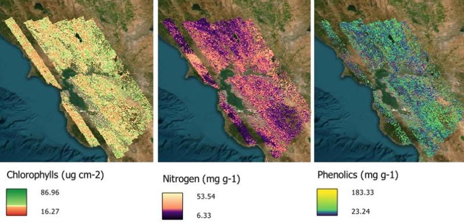
The Western Diversity Time Series (WDTS) AVIRIS-Classic Derived Plant Trait Mosaics, 2013-2018 is now available from ORNL DAAC. This dataset holds maps of 14 foliar functional traits derived from Airborne Visible/Infrared Imaging Spectrometer - Classic (AVIRIS-C) imagery over the western United States for the WDTS project. Imagery was acquired from April 10, 2013, to August 16, 2018, and a georeferenced, corrected surface reflectance product was developed for WDTS for 87 acquisitions. 

Foliar traits (i.e., foliar concentrations of nitrogen, cellulose, lignin, fiber, sugar, starch, calcium, potassium, phosphorus, sulfur, phenolics, and nonstructural carbohydrates) were derived from the reflectance product by applying partial least squares regression models. In addition, area concentration of chlorophyll A+B and leaf dry mass per area were estimated. This dataset will enable multitemporal analyses of plant functional traits and biodiversity at the ecoregion scale. The data are provided in cloud optimized GeoTIFF format.

Access the WDTS AVIRIS-C Derived Plant Trait Mosaics, 2013-2018 data and more information.

Image
Image Caption

These images show foliar concentrations of chlorophyll A+B, nitrogen, and phenolics in the Bay Area flightbox around San Francisco, California, on April 10, 2013. Concentrations were derived from a mosaic of AVIRIS-C images acquired on that date and estimated with regression models to relate surface reflectance to field measurements of these foliar functional traits. Credit: ORNL DAAC; basemap: ESRI World Imagery

MASTER: FireSense, California and Southern United States, Spring 2025 Dataset Released

ORNL DAAC released the Advanced Spaceborne Thermal Emission and Reflection Radiomter (MODIS)/Advanced Spaceborne Thermal Emission and Reflection Radiomter (ASTER) Airborne Simulator (MASTER): FireSense, California and Southern United States, Spring 2025 dataset, which includes Level 1B data products from the MODIS/ASTER Airborne Simulator (MASTER) instrument. The spectral data were collected as part of the FireSense project during 7 flights aboard a NASA B200 aircraft over California, Alabama, Georgia, and Florida from March 17 to April 18, 2025. 

The FireSense project is focused on delivering NASA's unique Earth science and technological capabilities to operational agencies, striving towards measurable improvement in U.S. wildland fire management. Data products include Level 1B georeferenced multispectral imagery of calibrated radiance in 50 bands covering wavelengths of 0.460 to 12.879 micrometers at approximately 10-meter spatial resolution. The Level 1B file format is HDF-4. 

The dataset also includes flight paths, spectral band information, instrument configuration, ancillary notes, and summary information for each flight, and browse images derived from each Level 1B data file.

Access MASTER: FireSense, California and Southern United States, Spring 2025 data and more information.

Aboveground Biomass for Howland Forest, Maine, 2012-2023 Dataset Now Available

The Aboveground Biomass for Howland Forest, Maine, 2012-2023 dataset is now available from ORNL DAAC. This dataset holds aboveground biomass (AGB) estimates at 10-meter spatial resolution for the Howland Research Forest in central Maine for 2012, 2015, 2017, 2021, and 2023. Forest inventory data were collected using 50 fixed-area plot sampling during the summers of 2021, 2023, and 2024. 

Plots included permanent inventory plots around existing flux towers and additional plots to ensure representation of various forest conditions. Howland Research Forest is a low-elevation transitional forest dominated by spruce and hemlock, with conifer and northern hardwood species. The data are provided in cloud optimized GeoTIFF format.

Access Aboveground Biomass for Howland Forest, Maine, 2012-2023 data and more information.

Forest Aboveground Biomass for Maine, 2023 Dataset Released

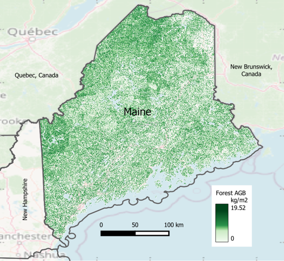
ORNL DAAC released the Forest Aboveground Biomass for Maine, 2023 dataset. This dataset holds estimates of forest aboveground biomass (AGB) for Maine in 2023. AGB was estimated using airborne LiDAR data from the 3D Elevation Program (3DEP) project and a deep learning convolutional neural network model. 

The airborne LiDAR datasets used in this mapping were collected in different years. Stand-level biomass succession models, developed from the USDA Forest Service Forest Inventory and Analysis data, were applied to project biomass estimates to the year 2023 with 10-meter spatial resolution. The data are provided in GeoTIFF format.

Access Forest Aboveground Biomass for Maine, 2023 data and more information.

Image
Image Caption

Forest aboveground biomass (AGB) for Maine in 2023. Credit: ORNL DAAC

STAQS AVIRIS-NG-derived Methane and Carbon Dioxide Plumes, 2023 Dataset Now Available

The STAQS AVIRIS-NG-derived Methane and Carbon Dioxide Plumes, 2023 dataset is now available from ORNL DAAC. This dataset contains enhanced column-integrated methane (CH4) and carbon dioxide (CO2) acquired from 211 flight lines across North America imaged by the AVIRIS-NG instrument between June 26 and August 15, 2023, for NASA's Synergistic TEMPO Air Quality Science (STAQS) campaign. 

A total of 177 greenhouse gas plumes were identified and delineated, of which 74 were CH4 and 103 were CO2. The data are provided in GeoTIFF and JSON formats.

Access STAQS AVIRIS-NG-derived Methane and Carbon Dioxide Plumes, 2023 data and more information.

ACT-America Campaign Catalog Released

ORNL DAAC released the ACT-America Campaign Catalog, which provides information about the airborne campaigns of the Atmospheric Carbon and Transport (ACT-America) project. ACT-America advanced atmospheric greenhouse gas inversions to a high level of accuracy and precision through new methods and models that improved knowledge of atmospheric transport, prior flux models, and space-based observations. 

The catalog compiles flight details for the five campaigns conducted during Summer 2016, Winter 2017, Fall 2017, Spring 2018, and Summer 2019 across three regions of the eastern and central United States. Data include flight dates, regions, objectives, weather conditions, instrument status, aircraft flight paths, detailed weather reports, and measurement summary figures. The data are provided in comma separated values (CSV) and compressed Keyhole Markup Language (KMZ) formats, along with figures as JPEG and Portable Network Graphics images.

Access the ACT-America Campaign Catalog and more information.

Image
Image Caption

This graphic from the ACT-America Campaign Catalog shows a time-height cross-section of LiDAR-derived normalized aerosol backscatter on August 24, 2016, across three regions of the eastern and central United States. Credit: ORNL DAAC

BioSCape Vegetation Surveys Berg and Eerste River Catchments, South Africa, 2022-2023 and AVIRIS-NG Level 2B Enhanced Surface Reflectance Datasets Now Available

Two new datasets from the Biodiversity Survey of the Cape (BioSCape) project—Vegetation Surveys Berg and Eerste River Catchments, South Africa, 2022-2023 and AVIRIS-NG Level 2B Enhanced Surface Reflectance—are now available from ORNL DAAC. 

The Vegetation Surveys Berg and Eerste River Catchments, South Africa, 2022-2023 dataset contains vegetation plot survey data collected at 36 sites across the Berg and Eerste River catchments in the Western Cape, South Africa, collected during 2022 and again in 2023. Sampling protocols were designed by the BioSCape Leadership team for use by multiple teams to generate standardized and comparable vegetation plot data across sites. 

Each circular, 10-meter plot was representative of the vegetation community and species were identified at each 1-meter mark along the North-South and West-East transects, totaling 42 identifications per plot. Fractional ground cover of the plot, fractional vegetation dominance, and rarefaction counts for each plot were recorded at all plots from 2023. These data are provided in comma separated values (CSV) format. 

The AVIRIS-NG Level 2B Enhanced Surface Reflectance Datasets dataset holds corrected surface reflectance from the AVIRIS-NG instrument flown on a NASA Gulfstream III aircraft. AVIRIS-NG imagery was acquired in October-November 2023 over the Greater Cape Floristic Region (GCFR), South Africa. Level 2B surface reflectance was derived from Level 1B radiance data in 425 bands, and this enhanced Level 2B product includes topographic, glint, and bidirectional reflectance distribution function (BRDF) corrections. 

Data were georeferenced and projected into UTM coordinates. These files hold the original native ancillary information relevant to the image, as well as the ancillary masks used in the creation and parameterization of the topography, glint, and BRDF corrections applied to enhance these image products. The data are provided in netCDF format.

Access the data and more information via each product link above.

Socioeconomic Data and Applications Center (SEDAC)

Data From SEDAC Are Available Again in Earthdata Search

Effective June 17, 2025, all SEDAC datasets have been relocated to Earthdata Cloud and can once again be found in Earthdata Search. Users can access over 350 data collections previously available through SEDAC.

On April 30, 2025, the contract for NASA's Socioeconomic Data and Applications Center (SEDAC), managed by Columbia University's Center for Integrated Earth System Information (CIESIN), was terminated and the datasets SEDAC curated were no longer available. Since then, the Earth Science Data and Information System (ESDIS) project has been working to get the datasets rehoused. 

An Earthdata Login is required to view and download the data. If you are unfamiliar with the Earthdata Login and how to obtain an account, watch this tutorial video on what Earthdata Login is and how to get access.

All of the datasets are complete and will no longer be updated with new versions or collections. The dataset lifecycle data basics page explains collection progress states for more information.

If you have any questions about the data, please contact Earthdata Support.

Details

Last Updated

July 18, 2025

Published

July 18, 2025

Data Center/Project

Atmospheric Science Data Center (ASDC)
Goddard Earth Sciences Data and Information Services Center (GES DISC)
Global Hydrometeorology Resource Center DAAC (GHRC DAAC)
National Snow and Ice Data Center DAAC (NSIDC DAAC)
Oak Ridge National Laboratory DAAC (ORNL DAAC)
Socioeconomic Data and Applications Center (SEDAC)